
Nagorno-Karabakh
Location Nagorno-Karabakh in the larger Karabakh region, which extends over Armenia and Azerbaijan, Nagorno-Karabakh |

Nagorno-Karabakh ( Armenian Լեռնային Ղարաբաղ Lernajin Gharabagh , scientific transliteration Leṙnayin Łarabał; Azerbaijani Dağlıq Qarabağ or Yuxarı Qarabağ , "mountainous black garden" or "upper black garden", and Nagorno-Karabakh ) is a majority of Armenians inhabited region in the southeast of the Lesser Caucasus . Also in use is the transcription of the Russian name Нагорный Карабах, Nagorny Karabach . It is part of the larger Karabakh region and includes its central, mountainous part, dominated by the Karabakh Mountains and theKarabakh highlands .
The region is disputed between Armenia and Azerbaijan , the Nagorno-Karabakh conflict is still ongoing. As a political term, Nagorno-Karabakh is often equated with the former Nagorno-Karabakh Autonomous Region within the former Azerbaijani SSR and with the resulting de facto regime of the Artsakh Republic , which, according to the United Nations and the Council of Europe, is still part of the national territory of Azerbaijan. After the collapse of the Soviet Union in 1991, the conflict escalated into war, so that from the end of 1994 Nagorno-Karabakh and neighboring areas were largely controlled by Armenians. Since the Nagorno-Karabakh war in 2020 , larger areas of the region have again been controlled by Azerbaijan.
Names
The name is derived from the name of the larger Karabakh region . This is composed of originally Persian and Turkish word components, so in Azerbaijani "qara" means "black" and "bağ" means "garden", together they mean "black garden". The Armenians mainly use the term Arzach (Armenian Արցախ ', in scientific transliteration Arc'ax , in English transcription Artsakh ) for Nagorno-Karabakh , which historically refers to the province of Arzach of the ancient Armenian kingdom of the Artaxides and the medieval kingdom of Arzach .
geography

The region is located in the Greater Karabakh Region, which stretches between the Kura and Aras Rivers . While the northeastern neighboring Niederkarabach lies in the plains of the Kura in the Kura-Aras lowland , Nagorno-Karabakh includes the adjoining foothills of the Lesser Caucasus , in particular the Karabach Mountains and the Karabach Highlands as well as the Murovdağ mountain range in the north . This is where the highest elevation is located with the 3724 m high Gamış dağı . In the south, the region is bordered by the Macaw, which also forms the state border with Iran here. The Sangesur or Sjunik region adjoins it in the west . The region is not precisely delimited. More recently, it is often identified with the former Nagorno-Karabakh Autonomous Oblast within the former Azerbaijani SSR , which, however, only spanned part of the Karabakh Mountains. The autonomous area covered 4,400 square kilometers.
Nagorno-Karabakh falls to the east to the Kura lowlands and to the south to the Aras, almost all rivers flow from west to east or south. The largest rivers are the Hakari, which flows into the Aras, and the Tartar and Chatschen that flow through Niederkarabach into the Kura . Over the millennia, canyons were created on these waterways . The largest lake is the Sarsang reservoir on Tartar. The largest city in the region is Stepanakert with over 50,000 inhabitants , which is also the capital of the Artsakh Republic. All other places are much smaller with a maximum of a few thousand inhabitants. Historically significant as the former capital of the Khanate of Karabakh Shusha ( Armenian Շուշի Shushi ), which has lost much of its population because of the Nagorno Karabakh conflict.
The landscape changes from steppe in the lower valleys and plains through dense oak and beech forests to birch forests and alpine meadows in the higher elevations. The average annual temperature is 11 degrees Celsius.
story
Until the 19th century

The area of Nagorno-Karabakh was often part of Armenia in ancient times, but also several times of neighboring Albania in today's Azerbaijan, or it formed the borderland of both states. In the 4th century Christianity became the state religion in both countries. According to the Armenian view, Nagorno-Karabakh was predominantly populated by Armenians at least from the Middle Ages. As a result of the Arab occupation in the 8th century, the region was under the control of various, predominantly Muslim peoples, Kurds , Arabs , Persians and Turkic tribes who immigrated to Lower Karabakh . At the latest when the Seljuks conquered the land in the 11th century, the ethnic groups belonging to the Islamic culture made up the majority of the population in the greater region. In Nagorno-Karabakh, on the other hand, there was a strong Armenian presence through the principalities of the Meliks , with the Armenian princes of the House of Hassan-Jalaljan from the principality of Khatschen ruling the area from the 12th to the 15th centuries and the Gandsassar monastery as the seat of the Catholic of Aghwank in 1216 (Albania) founded the Armenian Apostolic Church .

Local Armenian principalities were able to hold out until the 18th century: the five principalities of Karabakh , which ruled as vassals of changing empires. Under the Safavid dynasty (1501–1736), the princes were vassals of the Persian shahs and at times subordinate to the Khan of Ganjah . At the end of the 16th century, the Ottomans temporarily took control , but were successfully pushed back by the Persian Empire in several wars in the 17th century. With the collapse of the central power of the Safavids in the 18th century, the neighboring Karabakh Khanate made itself independent, then subjugated the Armenian princes and incorporated them into the Khanate in 1750. In 1805 the Khan of Karabakh submitted to the Russian Empire . In 1813 Persia ceded Karabakh and other khanates to Russia in the Treaty of Golestan , with Karabakh becoming part of the Elishavetpol Governorate .
In the 20th and 21st centuries
After the October Revolution of 1917, both Armenians and Azerbaijanis claimed Nagorno-Karabakh. Violent armed conflicts between the Democratic Republic of Armenia and the Democratic Republic of Azerbaijan broke out in the area after the joint confederation of states collapsed. After the conquest by the Red Army , the Central Committee of the Communist Party of Russia decided in July 1921 to divide the Nagorno-Karabakh area and incorporate the core part of it as the so-called Nagorno-Karabakh Autonomous Oblast and the rest directly to the Azerbaijani SSR , which was implemented in 1923. Until 1929, another part of Nagorno-Karabakh belonged to the Red Kurdistan, an autonomous province. In the 1960s there were again isolated riots. The Armenians felt discriminated against and were concerned because their share of the Nagorno-Karabakh population was slowly but steadily declining (1926: 93.5%, 1989: 73.5%).
In 1988 the conflict escalated. There were mass demonstrations in Armenia as well as shootings with several hundred dead and pogroms in Azerbaijan. As a result, there were bilateral waves of deportation and the flight of the respective minority. The Nagorno-Karabakh Republic declared its independence in September 1991, and in November Azerbaijan abolished the region's autonomous status. From 1992 onwards, after the Chodjali massacre , the Maraga massacre and a counter-offensive by the Karabakh army, there was increased use of force on both sides; from 1993, Armenia participated in the conflict with its own associations. During the 1994 armistice, Armenians controlled a large part of the area claimed by the Nagorno-Karabakh Republic and a buffer zone with Azerbaijan. Nagorno-Karabakh's independence is not recognized internationally. After 1994 there were several failed mediation attempts and repeated fighting. After fighting in the summer of 2020, another war broke out at the end of September . On November 9, 2020, both parties to the conflict signed a new ceasefire agreement mediated by Russia. As a result of the Azerbaijani offensive, the Republic of Artsakh had lost a third of its territory, including traditional Armenian settlements and cities such as Hadrut , which formerly belonged to the Autonomous Oblast . As a result of the armistice, Artsakh had to surrender another third of the area surrounding the former oblast to Azerbaijani control.
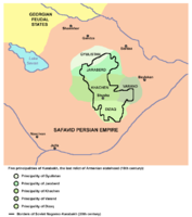
The five principalities of Karabakh in the 16th century.

The Nagorno-Karabakh Autonomous Oblast , 1923-1991


literature
- Emil Souleimanov: The conflict over Nagorno-Karabakh. In: OSCE Yearbook 10 (2004), Vol. 10 (2004), pp. 217–236.
- Haig E. Asenbauer: On the right of the Armenian people of Nagorno-Karabakh to self-determination . Wilhelm Braumüller, Vienna 1993. (Series Ethnos Vol. 41) ISBN 3-7003-0978-3 .
- Hravard Hakobian, Manfred Richter (ed.): Armenian Nagorno-Karabakh / Arzach in the struggle for survival: Christian art, culture, history . Edition Hentrich, Berlin 1993, ISBN 3-89468-072-5 .
- Johannes Rau: Nagorno-Karabakh in the history of Azerbaijan and the aggression of Armenia against Azerbaijan . Köster, Berlin 2009, ISBN 978-3-89574-695-6 . (Political Science Series; Volume 16)
Web links
- Website about the history and culture of the Azerbaijanis of Karabakh (English)
- "State without recognition" (DLF, Europe today, September 1, 2006)
- BBC on Nagorno Karabakh
- Ministry of Foreign Affairs of the internationally unrecognized Republic of Artsakh (English)
- English and Russian short messages from Kawkasski Usel from Nagorno-Karabakh
Individual evidence
- ↑ a b Michael Reinhard Hess: tanks in paradise. The Nagorno-Karabakh conflict between Armenia and Azerbaijan . Publishing house Dr. Köster, Berlin 2016, ISBN 978-3-89574-906-3 , pp. 29–32, 23–28 ( verlag-koester.de [PDF; 1.7 MB ] - excerpt from the publisher).
- ↑ Nagorno-Karabakh - Encyclopedia - Brockhaus.de. Retrieved October 7, 2020 .
- ^ Robert H. Hewsen, Armenia: A Historical Atlas . The University of Chicago Press, 2001, pp. 163ff, 264.
- ↑ a b Nagorno-Karabakh. In: Encyclopaedia Britannica. Accessed October 7, 2020 .
- ^ A b Andranik Eduard Aslanyan: Nagorno Karabakh Chronology . In: Energy and geopolitical actors in the South Caucasus. The Nagorno-Karabakh conflict in the field of tension between interests (1991–2015) . University thesis. Springer Fachmedien Verlag, Wiesbaden 2019, ISBN 978-3-658-28516-6 , p. 335-349 , doi : 10.1007 / 978-3-658-28516-6 ( springer.com [PDF; 710 kB ]).
- ↑ Aser Babayev: Armenia . In: Neither war nor peace in the South Caucasus. Background, actors, developments on the Nagorno-Karabakh conflict . Nomos, Baden-Baden 2014, ISBN 978-3-8487-1396-7 , pp. 73–90 , doi : 10.5771 / 9783845254500 ( nomos-elibrary.de - publisher preview ).
- ^ Uwe Halbach: Nagorny-Karabach. Dossier. In: Conflict portraits. Federal Agency for Civic Education, November 20, 2017, accessed on September 28, 2020 .
- ↑ Heavy fighting in the Azerbaijani region of Nagorno-Karabakh. Deutsche Welle , September 27, 2020, accessed on September 28, 2020 .
- ↑ Nagorno-Karabakh: Armenia's head of government orders an end to the fighting over Nagorno-Karabakh. In: zeit.de . November 10, 2020, accessed November 11, 2020 .
Coordinates: 39 ° 48 ' N , 46 ° 42' E