
Brown coal mine on the Sonnenberg
| Lignite mine on the Sonnenberg | |||
|---|---|---|---|
| General information about the mine | |||
 |
|||
| other names | Vitingsberg shaft | ||
| Mining technology | Civil engineering | ||
| Information about the mining company | |||
| Operating company | Corporation | ||
| Employees | unknown | ||
| Start of operation | 1841 | ||
| End of operation | 1842; final dismissal in 1856 | ||
| Successor use | no | ||
| Funded raw materials | |||
| Degradation of | Brown coal | ||
| Brown coal | |||
| Lignite deposits on the Sonnenberg near Parchim | |||
| Mightiness | not fully explored | ||
| Greatest depth | 20.37 m (without sump ) | ||
| Geographical location | |||
| Coordinates | 53 ° 24 '18.8 " N , 11 ° 48' 32" E | ||
|
|||
| Location | On the northeastern edge of the Sonnenberg | ||
| local community | Parchim | ||
| District ( NUTS3 ) | Ludwigslust-Parchim district | ||
| country | State of Mecklenburg-Western Pomerania | ||
| Country | Germany | ||

The lignite mine on Sonnenberg was an investigation mine for lignite deposits in what is now Parchim's municipality in the Ludwigslust-Parchim district . The "brown coal mine on Sonnenberg" is located in the Sonnenberg nature reserve , three kilometers southwest of Parchim, immediately north of the village of Kiekindemark . The eponymous Sonnenberg is 500 meters to the east. It was placed under protection on May 1, 1957 with the purpose of protecting and developing a forest complex on an old moraine site .

History
Since 1734 the Domanialämter Eldena, Plau, Wredenhagen and Marnitz had been pledged to Prussia. It was not until 1787 that these areas of responsibility came under the sovereignty of the Mecklenburg duke. Since there was already a lot of mining activity in other German lands (including lignite), the sovereign was very interested to find out where and which mineral resources were stored in his lands. The suggestion for corresponding search and exploration work in Mecklenburg came from the Braunschweig mountain Abich, who was in Bad Doberan for a cure in 1816 . Duke Friedrich Franz I sent him the research results of the local geologist Carl Zintgraff - regarding his research from the years 1790/91 in the Bockup / Malliß district of Ludwigslust-Parchim . After reviewing these documents, Abich recommended that the said area be investigated by means of drilling.
In 1817 he sent the Steiger Mengebier and the miners Goedecke and Müller from the staff of the Rudolphsgrube to the Bockup area for this work. He also came frequently for inspection and guidance.
Mengebier's son Friedrich August Albert, born in Conow near Malliß in 1810, took over the further exploration of the brown coal seams on the Sonnenberg and the surrounding area as construction manager from 1840 .
geology
The Ludwigslust physician Gustav Brückner was the first to believe that mineral resources rest in “ Viting ” . Among other things, in a publication published in 1825, he took the view that the " Vieting " was a limestone mountain.
Gypsum or lime could also be found there. This view could explain the occasional occurrence of mist-like haze.
After all, a large amount of brown coal was mined by the end of October 1841. Three large bushels of sifted brown coal cost 10 shillings, a ton of grus six shillings. The latter was considered a good fertilizer.


The Sonnenberg is an imposing Tertiary elevation . In the up to 108 m rising Vitingsberg, a hill in the chain of elevations known as the "Sonnenberg", a series of boreholes for brown coal was made in 1840. They also found what they were looking for; however, due to the lack of precise position / depth measurements, no exact assignment could be made.
The seams in the shaft are at the level of the Elde ; in Kiekindemark near the surface of the earth.
How confused the descriptions of the geological conditions on the Sonnenberg are is made clear by the following ( and this after only four years since the lignite mine was closed):
“In 1840, lignite was discovered near Parchim. Their storage is as follows: 1 ′ dam soil. 10'6 ″ Coarse sand and stones. 30 ′ Sandy alum soil. 21 ′ Very rich alum earth. 8 ′ brown coals. 1 ′ brown quicksand. (Total: 71'6 ″).
A company had received the right to the exploitation of this coal deposit from the city, and had also sunk a shaft and had it drifted a short distance into the coal seam; Unfortunately, however, it has been shown that the coals 14 'are under water at the point of the shaft and the pit has therefore been abandoned for the time being. The coal extracted there is said to have been used as a fertilizer, as in Champagne and Thiérarche, which is easy to explain if you take a look at the sandy city field and the magnificent beech trees of the Sonnenberg. But shouldn't it be worthwhile to bring the coals on the Elde to areas with less wood? "
Drilling results


The following drilling results are the most significant of a total of 28 documented layer images. Report on the continued drilling attempts in the Sonnenberg in 1853.
The stock corporation operating up to now was unwilling to continue working because of the failures (hardly usable brown coal, meanwhile used up share capital); it dissolved. A new stock company was formed. With their decision of March 7, 1853, the drilling tests were resumed in April. These began in a certain systematics initially on the southern slope of the Lilac Mountain. The first borehole reached only 40.449 m (≙ 139 ′) due to stone obstacles. Many obstacles resulted in the loss of a total of 40 pipes. Another well was close to fuller's earth mine at a depth of 44.523 set m.
A borehole was drilled between the "Dagekuhle" and the old shaft on the property of Mr. B. Hoffmann and reached a depth of 43.068 m. In order to examine the lignite deposit of the old shaft, borehole 12 was drilled 18 pools (≙ 32.4 m) east of it. The three brown coal seams have been able to prove themselves again. The result of these eight drill holes in total was not encouraging. The seams were only found in the vicinity of the shaft, but only in poor and unclean quality. First they asked:
"... for permission, through one of the royal. Prussian Oberbergamte zu Halle to be able to recruit an experienced miner at their expense to be allowed to make new drilling attempts in the Sonnenberge. The requested permission was immediately and willingly granted, the qualified miner was won over from Halle, and the new attempts at drilling began immediately and were continued throughout the summer.
In 1853 and 1854 these attempts were interrupted by an unfortunate incident. The miner he won had shot someone out of carelessness and is therefore under criminal investigation. One did not want to get involved with a new personality, therefore waited for the end of the investigation and thus the drilling attempts could not be resumed until the beginning of 1855 and should be finished at the latest Michaelis last year. In the meantime, the company has made a solemn promise to the local authorities that it will make its specific declaration by Johannis 1856 at the latest , either to start the construction of the mine itself immediately in accordance with a contract that has already been taken as a basis, or to guarantee its contractually To renounce claims entirely. As soon as these new drilling attempts are completed, the willing reader should be presented with a lengthy account of the successes of the same. "
| No. of the drill hole |
Location and location of the terrain |
Pierced mountain areas |
Strength of the same |
Depth of the drill holes |
Remarks |
|---|---|---|---|---|---|
| No. 3 | West of the Brunnen im Thale near the oak tree. | 1. Sandy loam. 2. Sandy clay. |
4 feet.
2 feet 6 inches. |
13 feet. | Not continued because of drift sand. |
| No. 7 | At the northern foot of the Vitingsberg, north of No. 5. | 1. Dam earth. 2. Coarse sand and stones. |
1 foot.
10 feet 6 inches. |
71 feet 6 inches. | Up to 10 feet deep was dug up to be able to attach the winch (mechanics) . The coal found here was particularly distinguished by its quality and thickness. |
| No. 24 | In Kiekindemark. | 1. Dam earth.
2. Clay. |
2 feet 6 inches.
2 feet 6 inches. |
42 feet 6 inches. | no |
| No. 25 | At the Parchim field border in the line between No. 3 and 7, northwest of the well. | 1. Yellow sand.
2. Alum earth. |
5 feet.
35 feet. |
43 feet
3 inches. |
The thickness of the lignite of 3 feet 3 inches shows that the camp in the direction from the well to the Vitingsberg is continuously increasing in strength. |
business
Establishing a business
The following newspaper articles announce the establishment of the company.

List of shareholders.

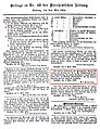
Extract from the Parchim newspaper of June 4, 1841.
Extract from the Parchim newspaper of June 4, 1844.
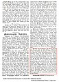
Excerpt from the Parchimchen newspaper from January 17, 1852

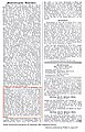
Excerpt from the Parchimchen newspaper from January 18, 1854.

Excerpt from the Parchimchen newspaper of July 15, 1854.
Excerpt from the Parchimchen newspaper dated November 30, 1854.
List of layers of the "Sonnenberg" borehole from 1945.


It is important to know the dimensions that fall during this period :
1 meckl. Feet = 0.291 meters.
1 laugh = 6 feet + 8 inches = 1,938 square meters.
1 mountain sheep = 150 pounds. 1 meckl. Square rod = 21.54 square meters.
1 to = 145 kilograms.
By contrast, 1 ton = 4 bushels ( To ) = 135.6 liter.
1 bushel in Parchim = 54,727 French liters.
100 Rostock bushels = 71.053 Parchimer bushels.
Shaft construction

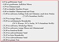
The wellbore was the presumption of the merchant Heucke in Feldmark the city Parchim , about 65 rods from the northwest corner of the house of the fountain in the oak conservation; about next to the above borehole III. In a publication from 1888 the following list of layers is given (information in meters):
Yellow-brown sand 0.5; yellow-brown sandy loam 0.8; gray-brown marl 1.0; black-brown and gray fine sand 1,2; Brown coal ? (black mica tone) 0.6; gray-brown fine sand 1.0; black-brown marl (mica clay) 0.2; brown fine sand 1.8; black-brown solid marl 8.9; gray and white-striped fat marl sand 1,2; black-brown, white-striped solid tone 0.8; bluish sharp sand 0.2; light brown sandy tone 1.0; gray fine sand 3.1; light brown fine sand 0.9; impure coal with gray clay and sand 0.1; solid brown coal with mica 0.6; brown-gray sand with clay and traces of coal 1.6; brown and white fat tone 0.1; gray fine and coarse sand 3.0; brown marl 0.1; Brown coal with little mica 1.5; gray striped clay with sand 0.9; gray-green fine mica sand 1.0; a total of 32.1 meters.
On the other hand, we find at Steffenhagen (page 038):
1st coal storage depth 13.1 m; Thickness 1.08 m.
2nd coal storage depth 20.37 m; Thickness 2.47 m.
And these numbers can be found again in the press release of the Parchimschen Zeitung of June 4, 1841 (see above figure).
Extraction, extraction and offset
It is good for posterity that Mengebier Senior and Mengebier Junior were mining at the same time.
In Bockup / Malliß and from 1840/1841 on the Sonnenberg the same equipment for sinking boreholes or shafts can be found as in the Bockup area.
It is thanks to this fact that we - in the absence of our own Parchimer archive sources - can roughly say which technical / technological processes there were on the Sonnenberg. The extensive knowledge of lignite mining in south-west Mecklenburg is due to the fact that mining only came to a standstill here in 1960 - 143 years after the first groundbreaking, and has thus been preserved.
The drilling apparatus that was used in the drilling tests was “colossal”. Since such boreholes were very wide, the tubes became very expensive and entry very difficult. The drill was so heavy that even at a depth of 9 m to 12 m it could only be moved with pulleys that were installed in a tower above the borehole. The drills that were used later were still so large that two people could still handle them at depths of 30 m or more. The use of such heavy equipment must not be blamed on bulk. In his contract, he was required to bring a drill with him at his own expense (which his father just didn't need).
The lignite was extracted in what is known as the pillar construction . The deposit area to be mined was aligned by means of ground sections driven in the collapse of the seam . Of these, laterally, in the brushing of the deposit from scheduled workings in fracture pillar ( " in the form of a ladies board " as described amount of beer) to a maximum of 3 m x 3 m Prepared. All buildings were built in door frame with cladding. The coal was extracted by hand using a wedge pick . This was followed by the robbery of the extension , whereby the hanging wall collapsed and fracture depressions surely formed above ground . To raise the pit water, Mengebier Junior built a pump system which was moved by horse- drawn art .
The ventilation took place naturally.
The first natural obstacle when going down was the water. According to the old records, the water table was shortly below the floor. The shareholders were also not interested in purchasing expensive steam-driven pumps because, according to the contract with the Parchim City Council, the entire plant would become the property of the city after five years.
Ergo, Friedrich Mengebier procured the usual suction pumps to hold down the pressing water. To raise the mine water , Mengebier built a pump system that was moved by horse art . Nevertheless, the extracted lignite was very wet. The late season brought little hope that the extracted lignite mass could be dried before autumn. Steffenhagen writes:
“Nevertheless, experiments have been made as to its usefulness as fuel; The lignite was firm and good, with a clearly recognizable fibrous texture, which on the whole corresponds to that of our conifers, but in terms of its usefulness as fuel for the first autumn and winter it could not deliver the favorable result that it would with better drainage of the Schachtes and with proper ventilation and drying out in a better season would certainly have delivered. At that time I myself had a good load fetched and used the material all winter to heat a room, the stove of which I had specially built for this purpose. The lignite burned heavily because of its wetness, but once caught in a fire it showed good heating power, but at the time of its strongest glow it spread an unpleasant vapor in the room, which smelled almost like bad sealing wax when it was burned. Towards the spring of the coming year, when the coal I kept in the dry place had evaporated and dried out, it turned out to be a much better fuel, and the haze that it gave off when it burned was lower. The judgments of our burners and brewers, who had also made experiments with lignite as fuel during the winter, were on the whole not favorable, and so it came about that in the spring of 1842, after the shaft had been covered with rain and snow during the winter had suffered a lot, the whole enterprise came to a standstill. The members of the stock corporation had to make new payments because, according to their opinion and judgment at the time, the successes had not met the brilliant expectations with which most of them had participated in the company. People were reluctant to spend even more money on mining coal, the sale and use of which seemed too dubious at the time. "
The writer of this article led the long-time chief forester of this forest area, forest engineer Eberhard Bach, to the alleged former manhole opening. Because the weather was too wet, we didn't succeed. If the conditions are more favorable, it will be made up for.
Individual evidence
- ↑ Mecklenburg-Western Pomerania Ministry of the Environment (ed.): The nature reserves in Mecklenburg-Western Pomerania . Demmler, Schwerin 2003, ISBN 3-910150-52-7 , Sonnenberg 45, p. 658 f .
- ↑ Günter Pinzke: "The Mallißer Brown Coal Mining". BoD-Verlag Norderstedt. 196 pages, 108 illustrations, with a foreword by the head of the Mining Authority of Mecklenburg-Western Pomerania, 2015. ISBN 978-3-7347-6915-3 .
- ^ Carl Wilhelm Heinrich Abich, born on December 4, 1772 in Braunschweig. As the leaseholder of the Schöningen saltworks , he was appointed Bergrat.
- ↑ This coal mine belonged to the Schöningen saltworks ; the coal mined has been used since 1741 to fire the salt pans in the Schöningen saltworks (closed in 1970) and Salzdahlum (closed in 1850).
- ↑ Mengebier's merits and his reputation at court must have been high, because the Grand Duke granted Lenzen's son Friedrich, who was to follow in his father's footsteps, an annual scholarship of 50 Reichstalers to study at the mountain school in the Prussian mining town of Eisleben . The student directory there from 1828 lists him as "Mengebier, Friedrich, born in Conow near Lenzen (Mecklenb.-Schw.)"
- ↑ Eugen Geinitz: The Flötzformationen Mecklenburg .. Separately impression in Issue 37 of the Archives of Friends of Natural History in Mecklenburg, Commission of the bookstore of Opitz & Co., Güstrow 1883. Page 130th.
- ↑ This is the symbol for "foot"; 1 foot = 0.291 m
- ↑ This is the symbol for "customs"; 1 inch = 2.54 cm
- ↑ Ernst Boll: Geognosy of the German Baltic Sea countries between Eider and Oder . Neubrandenburg. Carl Brünslow Verlag, 1846. Pages 187 and 188.
- ↑ Adolph Gottfried Ehrhart Steffenhagen: The brown coal warehouse in the sun mountains near Parchim. Archive for regional studies in the Grand Duchies of Mecklenburg and revue of agriculture. Sixth year, 1856. Schwerin, published by AW Sandmeyer's Hofbuchdruckerei.
- ↑ Adolph Gottfried Ehrhart Steffenhagen: The brown coal warehouse in the sun mountains near Parchim. Archive for regional studies in the Grand Duchies of Mecklenburg and revue of agriculture. Sixth year, 1856. Schwerin, Verlag der Hofbuchdruckerei von AW Sandmeyer, page 036.
- ↑ 1 Mecklenburg foot corresponds to 0.291 meters.
- ↑ Dammerde: former name for humus soil or arable topsoil; Today is known in geology it as bedrock (also briefly Imminent ) at or near the earth's surface befindliches rock that stands in a natural association with the rock of the subsoil. It is irrelevant whether this rock actually visible (at the surface receptive ) or from the ground , artificial ( anthropogenic ) bulk materials or, in polar and high mountain regions of glacier ice is covered. The following shows the original geological conditions that can be found at the corresponding location, unaffected by (sub) recent ( Holocene ) weathering , erosion or sedimentation . Conversely, (sub) recent formations such as soils (in the sense of soil science ), hillside rubble , or anthropogenic embankments are excluded from the term “pending”.
- ↑ alum earth: brown earth made up of lignite, clay and often decomposing pebbles; widespread in tertiary deposits.
- ↑ Triebsand: nowadays mainly referred to as floating sand . It is often a fine, floury-like sand which, when soaked in water, is very mobile and flowable; a suspension of sand in water, so to speak . Although it appears to be somewhat solid when undisturbed, it behaves like a special type of liquid under the influence of pressure : a non-Newtonian fluid .
- ↑ Sheet 1 of the list of shareholders of the AG “Braunkohlenschacht am Sonnenberg”. The list of shareholders comprises a total of three sheets with 65 names and paid-in capital of 840 thalers. Even construction manager Friedrich Mengebier - here in position 7 - was co-shareholder with 20 talen.
- ^ Eugen Geinitz: Archives of the Association of Friends of Natural History in Mecklenburg. 41st year. (1887). With 6 panels. Edited by the secretary. Güstrow, commissioned by the Opitz & Co. bookstore 1888.
- ↑ The Parchim'sche Scheffel is the old Berlin Scheffel, in Grabow and Strelitz the new Berlin Scheffel was used. In normal traffic, 5 Parchim's bushels (large measure) = 7 Rostock bushels (small measure).
- ↑ Steffenhagen, Adolph, Gottfried: The brown coal warehouse in the sun mountains near Parchim. Archive for regional studies in the Grand Duchies of Mecklenburg and revue of agriculture. Sixth year, Verlag der Hofbuchdruckerei von AW Sandmeyer, Schwerin 1856, pages 038–039
literature
- Franz Eugen Geinitz: Contribution to the geology of Mecklenburg . Carl Hinstorff's Hofbuchdruckerei, Rostock 1922.
- H. Kölbel: Overview of the lignite deposits of Mecklenburg. Archive of the LUNG MV, Güstrow, archive no. BR 0084. 1947.
- Adam Christian Mengebier: Collectio Varior Scriptorum Mecklenburgicorum . Vol. XIII, 1830 (copy of a translation from the Ludwigslust district archive, inventory no. L 3621).
- Karl Augustin: drilling in the Sonnenberg; when the Parchim brown coal deposits were discovered. In: Parchimer Zeitung, Supplement No. 124 of May 29, 1941.
- Charlotte Millies: The beginnings of a state economic policy in Mecklenburg in the 15./16. Century (= Mecklenburg Yearbooks . 101st year). 1937, p. 1-84 .
- Günter Pinzke: On the history of the mining and saltworks in Mecklenburg and their initiators . In: Scientific journal of the Wilhelm Pieck University Rostock . Ostseedruck, 1986, ISSN 0323-4630 .
- Günter Pinzke: personalities of the mining and salt works in Mecklenburg . In: Schweriner Blätter . Contributions to the local history of the Schwerin district. No. 6 , 1986, ISSN 0232-7902 .
- Hans Raeck: History of the Eisleber mountain school 1798–1928 . Bergschulverein Eisleben, delivery by Aug. Klöppel, Eisleben 1928.
- Steffenhagen, Adolph, Gottfried: The brown coal warehouse in the sun mountains near Parchim . In: Archives for regional studies in the Grand Duchies of Mecklenburg and Revue of Agriculture . Verlag der Hofbuchdruckerei von AW Sandmeyer, Schwerin 1856 (sixth year).
- Heinrich Alexander Stoll and Klaus Hallacz: From the robber Vieting. In: About the robber Vieting and other legends from Mecklenburg and the Spreewald. 1961, pp. 198-200.
- City of Parchim: Raeuber Vieting
- Burghard Keuthe: The legend of the robber Vieting. In: Parchimer Legends. 1995, p. 7.
- Fritz Hackert: A chat about the Parchimer Sonnenberg and the Buchholz.
Web links
- State Office for Agriculture and Environment West Mecklenburg (ed.): Management plan for the FFH area DE 2636-301 Sonnenberg near Parchim . PDF, 3.56 MB, p. 12.
- State Office for Agriculture and Environment West Mecklenburg (ed.): Expert landscape framework plan West Mecklenburg. First update , September 2008.