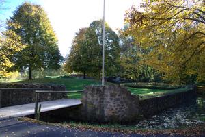
Ruhlkirchen Castle Hill
| Ruhlkirchen Castle | ||
|---|---|---|
| Creation time : | around 1100 | |
| Castle type : | Niederungsburg | |
| Conservation status: | Castle hill with remains of the curtain wall and moat | |
| Place: | Antrift Valley - Ruhlkirchen | |
| Geographical location | 50 ° 47 '45.9 " N , 9 ° 10' 54.8" E | |
| Height: | 250 m above sea level NN | |
|
|
||
The Ruhlkirchen castle hill is the excavation site of an abandoned moated castle next to the Antrift 200 meters northwest of the Ruhlkirchen district of the municipality of Antrifttal in the Vogelsberg district in Hesse .
description
The 30 by 26 meter large castle complex was built around 1100 on a bend in the river Drift at the southwestern foot of the Eulenberg by the Lords of Ruhlkirchen on an artificially created castle hill , surrounded by a moat fed by the drift . It was a Ziegenhain fiefdom . Around 1200 the enclosing walls were reinforced to two meters. From 1262 to 1272 the knight Gerlach von Ruhlkirchen and his wife Jutta are mentioned, who were later in the Landgrave Hessian service in Alsfeld . A Herdanus from Ruhlkirchen is documented in 1278.
Around 1293, the castle was destroyed by Landgrave Heinrich I of Hesse .
From 1986 to 1987 the remains of the castle were excavated and parts of the curtain wall were restored.
Individual evidence
- ↑ HStAM inventory document 26 No. 315
- ^ Ruhlkirchen, Vogelsbergkreis. Historical local lexicon for Hesse (as of July 23, 2012). In: Landesgeschichtliches Informationssystem Hessen (LAGIS). Hessian State Office for Historical Cultural Studies (HLGL), accessed on December 10, 2012 .
literature
- Rudolf Knappe: Medieval castles in Hessen. 800 castles, castle ruins and fortifications. 2nd Edition. Wartberg-Verlag, Gudensberg-Gleichen 1995, ISBN 3-86134-228-6 . P. 241 f.
Web links
- Ruhlkirchen Castle at burgenwelt.org
- Wasserburg Ruhlkirchen at vogelsberg-touristik.de


