
Caledonia (New York)
| Caledonia | |||
|---|---|---|---|
Location in New York
|
|||
| Basic data | |||
| Foundation : | 1803 | ||
| State : | United States | ||
| State : | new York | ||
| County : | Livingston County | ||
| Coordinates : | 42 ° 58 ′ N , 77 ° 51 ′ W | ||
| Time zone : | Eastern ( UTC − 5 / −4 ) | ||
| Residents : | 4,153 (as of: 2018) | ||
| Population density : | 94.6 inhabitants per km 2 | ||
| Area : | 44.13 km 2 (approx. 17 mi 2 ) of which 43.88 km 2 (approx. 17 mi 2 ) is land |
||
| Postal code : | 14423 | ||
| FIPS : | 36-051-11715 | ||
| GNIS ID : | 945451 | ||
| Website : | www.townofcaledoniany.com | ||
| Mayor : | Daniel L. Pangrazio | ||

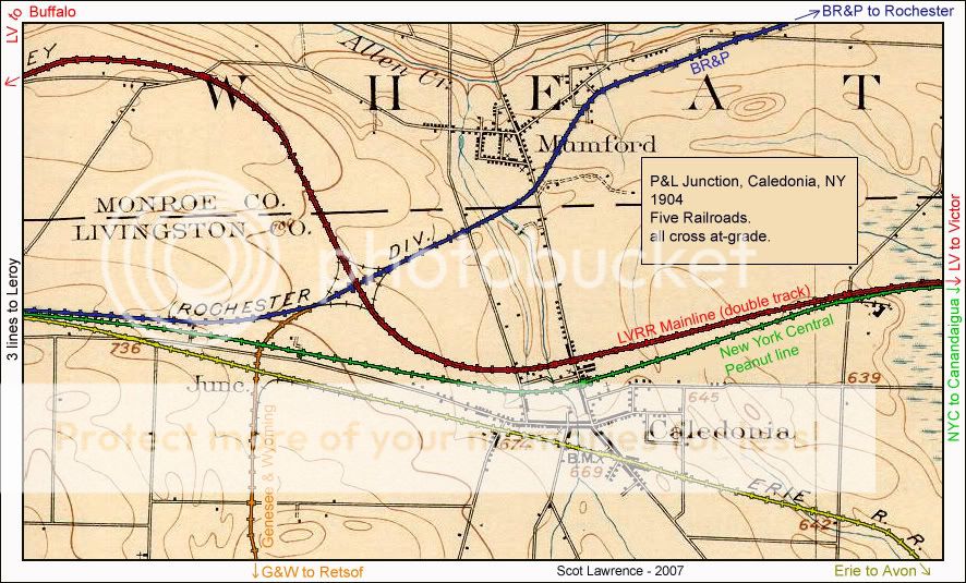
Caledonia is a town in Livingston County in the US state of New York in the United States of America . Within the town is the village of the same name, Caledonia , as the core town . From the end of the 19th to the second half of the 20th century, Caledonia was a railway junction where five lines from different railway companies met; a sixth ran on the edge of the local area.
geography
Geographical location
Caledonia is in a during the last cold ( Wisconsin Glaciation by) glacial shaped landscape. The local area is therefore largely flat; the soil is often loamy over limestone deposits . The Genesee River forms the eastern boundary of the town and is the only major watercourse on its area; the Oatka Creek runs partly directly north of the town.
Local division
The following districts are located in the area of the town:
- Caledonia ( Village and Census-designated place )
- Canawaugus
- Taylor
Neighboring communities
The neighboring towns are Wheatland in the north, Rush and Avon in the east, York in the south and Pavilion and Le Roy in the west. Wheatland and Rush are in Monroe Counties , Avon and York as well as Caledonia itself in Livingston County, Pavilion and Le Roy in Genesee County . Rochester is located approximately 30 km northeast of Caledonia.
history

| Population development | |||
|---|---|---|---|
| Census | Residents | ± in% | |
| 1820 | 2645 | - | |
| 1830 | 1618 | -38.8% | |
| 1840 | 1987 | 22.8% | |
| 1850 | 1804 | -9.2% | |
| 1860 | 2014 | 11.6% | |
| 1870 | 1813 | -10% | |
| 1880 | 1927 | 6.3% | |
| 1890 | 2188 | 13.5% | |
| 1900 | 2072 | -5.3% | |
| 1910 | 2248 | 8.5% | |
| 1920 | 1988 | -11.6% | |
| 1930 | 2305 | 15.9% | |
| 1940 | 2009 | -12.8% | |
| 1950 | 2529 | 25.9% | |
| 1960 | 3067 | 21.3% | |
| 1970 | 3832 | 24.9% | |
| 1980 | 4034 | 5.3% | |
| 1990 | 4441 | 10.1% | |
| 2000 | 4567 | 2.8% | |
| 2010 | 4255 | -6.8% | |
| 2018 estimate | 4153 | -2.4% | |
At the beginning of the 18th century, what is now Livingston County was part of the (hunting) area of the Seneca . After the American Revolution , it was opened up by European settlers. Around 1785, a first settlement was established east of the Genesee River in what is now the Town of Avon. From around 1797 there was also a settlement west of the river in the area of Caledonia, from which today's core town emerged.
Administratively, the area was then part of the town of Northampton (now Gates ). The formal establishment of the Town of Caledonia as a spin-off of the Town of Northampton took place on March 30, 1802, initially under the name Southampton . The change to the existing name Caledonia took place on April 15, 1806. The first church ( Presbyterian ) was consecrated in 1805; a first school was also opened in the first decade of the 19th century.
In 1812 the new town of Bellona, today's Le Roy, was separated from Caledonia. On March 26, 1819, part of the town area in the southwest was ceded in order to found the new Town York together with a previous part of the Town of Leicester . Within the town of Caledonia, the capital of the same name was elevated to a village in 1891 .
On the Genesee River in the east of the town, the Canawagus Reservation was about 5.2 km² in size from 1797 to 1826 . The Seneca had been awarded the area as one of ten Indian reservations in the Treaty of Big Tree , but sold it in 1826 under pressure in the Treaty of Buffalo Creek .
In 1840 the Genesee Valley Canal was opened between Rochester and Mount Morris , which ran parallel to the Genesee River through the eastern part of the town of Caledonia. The canal, which was lengthened to the Allegheny River near Olean (with a branch to Dansville ) in the following two decades, simplified the transport of goods considerably, but was soon in competition with railway lines. The first rail connection in the form of the Scottsville and LeRoy Railroad linked Caledonia with Scottsville, 13 km away in the town of Wheatland , since 1838 , but was still a horse-drawn railway with wooden rails, which in turn ceased operations in the early 1840s.

On July 1, 1853, the Canandaigua and Niagara Falls Railroad opened its route between Canandaigua and North Tonawanda on the Niagara River , which led in a west-east direction through the area of the town of Caledonia. On August 26, 1858, this railway company was taken over by the New York Central Railroad (NYC), where the route was informally referred to as the Peanut Line . East of the village of Caledonia, the connection was shut down in January 1939 and then dismantled.
The Buffalo, Corning and New York Railroad gradually started operating a railway line from Painted Post near Corning via Avon to Batavia from 1850 , which also crossed the town of Caledonia in an east-west direction from 1853. On October 29, 1858, this railway company was acquired by the newly founded Buffalo, New York and Erie Railroad , which in turn was under the control of the Erie Railroad from April 30, 1863 and pushed the expansion to Buffalo . The line, later operated by the Erie Lackawanna Railroad and Conrail , was shut down in the second half of the 1970s.
The Rochester and State Line Railroad opened on September 15, 1874 its first section from Rochester to Le Roy, which touched the area of the town of Caledonia in the northwest. This route was extended to Salamanca until 1878 . In 1885 the operating company was incorporated into the Buffalo, Rochester and Pittsburgh Railway , which in turn was taken over by the Baltimore and Ohio Railroad in 1932 .
On July 4, 1877, the closure of the Genesee Valley Canal on or after September 30, 1878 was approved. On November 6, 1880, the canal route was sold to the newly founded Genesee Valley Canal Railroad , which built a railway line from Rochester to Hinsdale on it. The rail company came under the control of the Pennsylvania Railroad in 1900 , which referred to the route as the Rochester Branch . It was shut down in 1963.
The main line Geneva – Buffalo of the Lehigh Valley Railroad (LV) ran from 1892 on the northern border of the town of Caledonia , which was linked to the crossing line of the Buffalo, Rochester and Pittsburgh Railway via connecting tracks. This line was also largely shut down by Conrail in the second half of the 1970s.
_(14750080594).jpg)
In 1895 the line of the Genesee and Wyoming Valley Railroad Company was opened, which had its starting point in the northwest of the town of Caledonia at the point where the route of the Buffalo, Rochester and Pittsburgh Railway to the crossing routes of the New York Central Railroad and the Erie Railroad as well as the connecting tracks to the route of the Lehigh Valley Railroad met. From this junction called Pittsburgh and Lehigh Junction (P&L Jct.), The route led around 20 km south to Retsof and Greigsville in the town of York, which is on a stretch of the Delaware, Lackawanna and Western Railroad . In 1899 the Genesee and Wyoming Valley Railroad Company was taken over by the Genesee and Wyoming Railroad (G&W). From the G&W, the Genesee and Wyoming Group emerged in the 1980s , whose subsidiary Rochester and Southern Railroad now serves all remaining rail routes in Caledonia: the route of the former Rochester and State Line Railroad , the original G&W and short ones in the local area Parts of the NYC and LV routes.
In 1864, Seth Green opened the Caledonia Fish Hatchery in the north of the town , the first commercial American fish farm with artificial insemination.
Infrastructure
traffic
The US Highway 20 and the New York State Route 5 run as national main roads in an east-west direction through the area of the town, the New York State Route 36 in a north-south direction.
Rail freight is offered by the Rochester and Southern Railroad .
education
In Caledonia there is the high school Caledonia-Mumford Central School , whose school district also includes Mumford in the neighboring town of Wheatland.
Sons and daughters of the place
- Elizabeth Martha Olmsted (1825–1910), poet
- Angus Cameron (1826–1897), US Senate politician
- Norman H. Meldrum (1841–1920), Lieutenant Governor of the State of Colorado
Web links
- Town Caledonia website. (English).
Individual evidence
- ↑ a b Caledonia town, Livingston County, New York. In: 2018 American Community Survey 5-Year Estimates. United States Census Bureau , 2019, accessed April 30, 2020 .
- ↑ Map of the Town of Caledonia. (PDF) Livingston County Planning Department, 2001, accessed April 30, 2020 .
- ↑ Map of the Town of Caledonia. 1998, accessed April 30, 2020 .
- ^ A b John Homer French: Gazetteer of the State of New York: Embracing a Comprehensive View of the Geography, Geology, and General History of the State, and a Complete History and Description of Every County, City, Town, Village and Locality . R. Pearsall Smith, 1860, p. 383 (English).
- ^ Laws of the State of New York: Passed at the Session of the Legislature . New York State Legislature, 1806, pp. 433-434 (English): “From and after the fifteenth day of April (1806), the town of Southampton (...) shall be called by the name of Caledonia”
- ^ A b c d e Peter Eisenstadt, Laura-Eve Moss, Carole F. Huxley: Encyclopedia of New York State . Syracuse University Press, 2005, ISBN 978-0-8156-0808-0 , pp. 248; 258; 915 (English).
- ^ Journal of the Franklin Institute . tape 26-30 . Pergamon Press, 1840, p. 228 (English): “Scottsville and Caledonia (...) 1838; 8 miles; motive power employed: horses (...) This railroad has no iron, and the cars run upon wooden ribbons ”
- ↑ Tom Tryniski: New York Central Railroad Station, Caledonia. In: OpenValley. Accessed April 30, 2020 (English).
- ↑ Interstate Commerce Commission (Ed.): Finance Docket 11870; New York Central Railroad Company Adandonment . November 26, 1938 (English): “The line sought to be abandoned (...) has been operated by the application since August 26, 1858. (...) permit abandonment (...) of that portion extending easterly from Caledonia to Holcomb (...) from and after 40 days from its date (1938-11-26) ”
- ↑ Interstate Commerce Commission (Ed.): Interstate Commerce Commission Reports: Decisions of the Interstate Commerce Commission of the United States. Valuation reports . tape 33 , 1933, pp. 448 (English).
- ^ Henry Varnum Poor: History of the Railroads and Canals of the United States . JH Schultz & Company, 1860, p. 246 : "The Buffalo, New York and Erie Railroad Company was organized (...) on the 24th October, 1858. On the 29th of the same month the Company purchased the Buffalo, Corning and New York Railroad"
- ↑ Interstate Commerce Commission (Ed.): Interstate Commerce Commission Reports: Decisions of the Interstate Commerce Commission of the United States. Valuation reports . tape 31 , 1933, pp. 490 (English): “Rochester and State Line Railroad Company (...) The portion of this road between Rochester and Le Roy, NY, about 24 miles, was completed and opened for operation on September 15, 1874”
- ↑ Interstate Commerce Commission (Ed.): Interstate Commerce Commission Reports: Decisions of the Interstate Commerce Commission of the United States. Valuation reports . tape 23 , 1933, pp. 221 (English): “Genesee Valley Canal Railroad (...) The main line extended from Hinsdale to Rochester about 98.37 miles”
- ↑ Interstate Commerce Commission (Ed.): Financial Docket 21890; Pennsylvania Railroad . December 21, 1961 (English): “Application and R. to Q. for authority to abandon (l) that portion of the Rochester Branch extending from its junction with the main line-Buffalo at Hinsdale, Cattaraugus County, NY, to Wadsworth Junction , Livingston County, NY, a distance of 82.56 mi. "
- ^ Encyclopedia of North American Railroads . Indiana University Press, 2007, ISBN 978-0-253-02799-3 , pp. 585 (English): “(The Lehigh Valley Railroad) built a line west from Geneva to Buffalo, opened in 1892”
- ↑ Interstate Commerce Commission (Ed.): Interstate Commerce Commission Reports: Reports and Decisions of the Interstate Commerce Commission of the United States . tape 135 , 1933, pp. 22 (English): “Of this mileage, 1.39 miles (...) from Greigsville to Retsof were constructed (...) prior to July 1891 and the remaining 10,845 miles, extending from Retsof to Pittsburgh and Lehigh Junction, were constructed by the Genesee and Wyoming Valley during the years 1894 and 1895 ”
- ^ Edward A. Lewis: American Shortline Railway Guide (5th Edition) . Kalmbach Publishing, Co., 1996, ISBN 978-0-89024-290-2 , pp. 128-129 (English).
- ↑ Map of the railway lines around Caledonia (Village). In: Topographic map from 1905; color coding by Scot Lawrence, 2007. 1905, accessed April 30, 2020 (the PRR route ran further east outside the map section).