Chênedouit
| Chênedouit | ||
|---|---|---|
|
|
||
| local community | Putanges-le-Lac | |
| region | Normandy | |
| Department | Orne | |
| Arrondissement | Argentan | |
| Coordinates | 48 ° 46 ′ N , 0 ° 20 ′ W | |
| Post Code | 61210 | |
| Former INSEE code | 61106 | |
| Incorporation | January 1, 2016 | |
| status | Commune déléguée | |
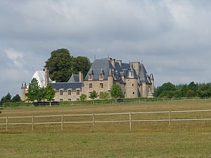
 The Château du Repas |
||
Chênedouit is a commune Déléguée in the French community Putanges-le-Lac with 174 inhabitants (as of January 1 2017) in Orne in the region of Normandy .
geography
Chênedouit is 17 kilometers northeast of the city of Flers . The Commune déléguée covers an area of 8.93 km² and is traversed by the Maufy and Guesnerie streams . There is a maritime climate with a moderate summer.
The place is on a granite plateau . Chênedouit is in the middle of a bocage landscape , which is why 750 hectares of the Commune déléguée are pastureland. Another 90 hectares are forest, 39 hectares are used for agriculture and 14 hectares are built on.
In Chênedouit, the road from Domfront to Falaise crosses the road from Putanges-Pont-Écrepin to Condé-sur-Noireau .
History and culture
The region was settled by the Celts from around 450 BC until it was occupied by the Romans . In the early Middle Ages, the Franks ruled here and later the Swedes . The place was first mentioned in 1402 under the name Chesneduit . The name developed from Chennedouit in 1762 to Chêne-Douit at the time of the French Revolution . In 1831 the place got its current name. The place name is made up of the words chêne ( French for oak ) and douit , which means waterhole .
The municipality of Chênedouit was created on January 23, 1822 through the merger of the previously existing municipalities of Chênedouit (366 inhabitants in 1821), Méguillaume (227 inhabitants) and Le Repas (98 inhabitants).
In the district of Le Repas is the Château du Repas , a feudal castle that was built between 1605 and 1615 under the rule of King Louis XIII. originated. The castle, located on a hill, is now privately owned and has been classified as a Monument historique since 1967 .
There are two churches in the Commune déléguée, the older of which is in the Méguillaume district . It was completed in the 15th century, rebuilt in 1742 and is dedicated to St. Sebastian . The second church, located in the main town of Chênedouit, was consecrated in 1841. There are also five calvaries in Chênedouit , four of which are made of granite and one of wood. With a menhir there is also a remnant from the Stone Age. It has been registered as a Monument historique since 1981.
With effect from January 1, 2016, the previous municipalities of Chênedouit , La Forêt-Auvray , La Fresnaye-au-Sauvage , Ménil-Jean , Putanges-Pont-Écrepin , Rabodanges , Les Rotours , Saint-Aubert-sur-Orne and Sainte- Croix-sur-Orne amalgamated to a Commune nouvelle with the name Putanges-le-Lac and have the status of a Commune déléguée in the new municipality . The administrative headquarters are in Putanges-Pont-Écrepin. The municipality of Chênedouit belonged to the Arrondissement of Argentan and the canton of Athis-de-l'Orne .
Population development
| year | 1962 | 1968 | 1975 | 1982 | 1990 | 1999 | 2009 |
| Residents | 249 | 238 | 215 | 222 | 190 | 167 | 173 |
Individual evidence
- ↑ Mairie de Chênedouit , annuaire-mairie.fr
- ↑ a b Ménil-Vin on valdorne.fr ( Memento of the original from April 17, 2013 in the Internet Archive ) Info: The archive link was inserted automatically and has not yet been checked. Please check the original and archive link according to the instructions and then remove this notice.
- ↑ Entry No. 61106 in the Base Mérimée of the French Ministry of Culture (French)
- ↑ Decree NOR 1200-15-0353 Prefecture nouvelle on the formation of the commune Putanges-le-Lac on 26 November 2015 .
