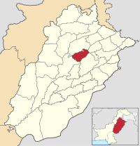
Chiniot (district)
|
Chiniot district ضلع چنیوٹ |
|
| State : |
|
| Province : | Punjab |
| Seat : | Chiniot |
| Coordinates : | 31 ° 43 ' N , 72 ° 59' E |
| Area : | 2 643 km² |
| Residents : | 1,495,982 (2017) |
| Population density : | 566 inhabitants per km² |
| Time zone : | PST ( UTC + 5 ) |
| Website : | |

|
|
The Chiniot District is an administrative district in Pakistan in the Punjab Province . The seat of the district administration is the city of the same name Chiniot .
The district has an area of 2643 km² and according to the 2017 census 1,495,982 inhabitants. The population density is 566 inhabitants / km². The Panjabi language is spoken by the majority in the district .
location
The district is located in the center of the Punjab Province, which is in western Pakistan.
history
The region was an important agricultural region during the Indus civilization . Later the region was u. a. Controlled by the Indo-Aryans , Greeks , Maurya , Kushana , Gupta , Ghaznavids , Mughals , Sikhs and British . The modern district emerged in February 2009 from parts of Jhang .
Demographics
Between 1998 and 2017 the population grew by 1.71% annually. About 26% of the population live in urban areas and about 74% in rural areas. 724,205 men, 771,744 women and 33 transgender people live in 266,109 households , resulting in a gender ratio of 93.8 men per 100 women and thus a rare surplus of women for Pakistan.
| year | population |
|---|---|
| 1972 | 570.775 |
| 1981 | 694.080 |
| 1998 | 965.124 |
| 2017 | 1,495,982 |
Individual evidence
- ↑ a b DISTRICT WISE CENSUS RESULTS CENSUS 2017. August 29, 2017, accessed May 30, 2019 .
- ↑ Pakistani Districts wise Population Census 2017. Accessed May 30, 2019 .