Döhlen (Probstzella)
|
Döhlen
Probstzella municipality
Coordinates: 50 ° 35 ′ 4 ″ N , 11 ° 22 ′ 21 ″ E
|
|
|---|---|
| Height : | 340 m above sea level NN |
| Area : | 1.94 km² |
| Residents : | 66 |
| Population density : | 34 inhabitants / km² |
| Incorporation : | January 1, 1960 |
| Incorporated into: | Unterloquitz |
| Postal code : | 07330 |
| Area code : | 036731 |
|
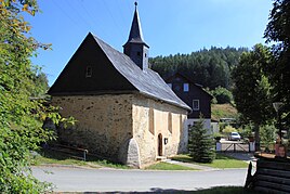
Village church in the village
|
|
Döhlen is a district of Probstzella in the Saalfeld-Rudolstadt district in Thuringia .
geography
Döhlen is north of Probstzella and one kilometer west of the federal highway 85 . The village can be reached via the district road 159. The area of the village with 194 hectares is located on areas of the Thuringian Slate Mountains . The corridor of the hamlet is docked and interspersed with forest. The village is located in a side valley of the Loquitz . The village stream flows in it. The mean altitude is 340 meters above sea level.
history
The first documentary mention took place on January 5th, 1380. Reclamation began in this area in the 12th century. The established village belonged to the Counts of Schwarzburg-Leutenberg , later it was taken over by the Lords of Lengefeld, based in Schweinbach . In 1747 the princely chamber of Schwarzburg-Rudolstadt acquired two estates in Laasen and Döhlen from the Lengefeld family for 12,000 guilders. There is a small church on the slope of the Kirchberg . In 1863 eight farming families lived in the village. The place in the Leutenberg area belonged to the sovereignty of the Principality of Schwarzburg-Rudolstadt in 1918 .
Today 66 people live in Döhlen.
Individual evidence
- ^ Wolfgang Kahl : First mention of Thuringian towns and villages. A manual. 5th, improved and considerably enlarged edition. Rockstuhl, Bad Langensalza 2010, ISBN 978-3-86777-202-0 , p. 57.
- ^ Döhlen on the website of the municipality of Probstzella ( Memento from May 27, 2017 in the Internet Archive )
