
Döllnitz (Upper Palatinate)
|
Dollnitz
Leuchtenberg market
Coordinates: 49 ° 33 ′ 34 ″ N , 12 ° 16 ′ 12 ″ E
|
||
|---|---|---|
| Height : | 480 m | |
| Incorporation : | July 1, 1976 | |
| Postal code : | 92705 | |
| Area code : | 09659 | |
Location of Döllnitz in Bavaria |
||
 Döllnitz (2014)
|
||

Döllnitz is a district of the Leuchtenberg market in the Neustadt an der Waldnaab district .
geography
The place is in the Northern Upper Palatinate Forest Nature Park in the Pfreimd Valley . The B 22 leads 600 meters east of Döllnitz, 1.2 kilometers away is the A 6 motorway in a north-westerly direction .
history
Slavic settlement
Slavic place names such as Döllnitz, Söllitz , Köttlitz , Gleiritsch , Hohentreswitz or Trefnitz document an early settlement of the area around the Pfreimd. Slavic settlers infiltrating from the east met Bavarians advancing northwards from the south . In a further settlement phase, the focus of which was in the 10th and 11th centuries, a number of "dorf" places such as Pamsendorf or Fuchsendorf emerged, to which further clearing settlements, the "richt" places and "ried" places such as Trichenricht , Lampenricht or Zeinried followed. Place names ending in “schwand” such as Großenschwand or Kleinschwand are cleared settlements. The Slavic-sounding place name Trausnitz is not one of these early settlement names. Initially it only referred to the Trausnitz and can be found in the files as "Traußnit, Trausniht, Trausnicht or Truwesnicht".
The Döllnitzer family
The Döllnitzer family appeared in documents from the early 12th century. The sex has been traceable since around 1130, when "Adalbertus de Tolinze" appeared as a witness in a donation. Between 1138 and 1146 "Adalbertus de Tolnce" transferred property to the Rohr monastery . In 1177 a document named a "Heinricus de Tolnz" as a witness. The noble free Adalbert and Heinrich von Döllnitz were feudal men of the margraves of Cham and Vohburg. You later switched to an employment relationship with the Landgraves of Leuchtenberg . The place Döllnitz was transferred to the Paulsdorfer in 1280 with the castle Wernberg. It later came back into the possession of the Landgraves of Leuchtenberg.
Parish
The parish of Döllnitz with the Catholic Church of St. Jakob is mentioned for the first time in the parish directory from 1326. In the 14th century it belonged to Leuchtenberg. In 1438 there was a deanery in Leuchtenberg with the parishes of Döllnitz, Köblitz, Luhe, Michldorf, Pfreimd and Schirmitz. Döllnitz existed as a parish until 1671, when it became a branch of Leuchtenberg.
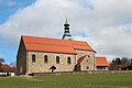
St. Jacob Church
In Döllnitz there was a Gothic church in the 14th century at the latest, the place was an independent parish. The turmoil of the Thirty Years' War from 1618 to 1648, which was a conflict over supremacy in the Holy Roman Empire of the German Nation and in Europe and at the same time a religious war, had reached the Upper Palatinate in 1621, with devastating economic, social and cultural effects The area around Döllnitz was badly affected. The church fell into disrepair. In 1685 the residents of Döllnitz rebuilt the formerly Gothic church. The church was rebuilt in 1927/1928.
Tax District and Parish Education
The Kingdom of Bavaria was divided into 15 districts in 1808. These districts were named after rivers based on the French model ( Naabkreis , Regenkreis , Unterdonaukreis , etc.). The districts were divided into district courts. The districts in turn should be divided into individual municipality areas. In 1808 the Vohenstrauß Regional Court was divided into 47 tax districts. One of them was the Döllnitz district with the villages of Döllnitz, Bernrieth, Preppach, Wittschau and the wastelands of Schönmühle and Thonmühle. From 1821 to 1830 there was the independent community of Döllnitz with the villages of Döllnitz, Bernrieth and the deserted Tanzmühle and Thonmmühle. In 1830 the independent municipality of Reisach was dissolved and incorporated into the municipality of Döllnitz. In 1946 Reisach was reassigned to Trausnitz in the Nabburg district. Fischerhammer and Kainzmühle were incorporated into the Döllnitz community in 1946 from the dissolved community of Woppenrieth. As part of the municipal reform in Bavaria, the municipalities of Altenstadt bei Vohenstrauß , Böhmischbruck , Döllnitz, Kaimling , Oberlind , Roggenstein and Waldau were initially incorporated into the Vohenstrauß registry office district on January 1, 1968 . With effect from January 1, 1972, Kaimling, Oberlind, Roggenstein and Waldau were incorporated into Vohenstrauss. On July 1, 1976, the Döllnitz community was again separated from the Vohenstrauß registry office district. On May 1, 1978 Döllnitz came to Markt Leuchtenberg with the place Preppach.

Döllnitz (2016)
St. Jakob (2016)
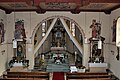
St. Jakob (2016)
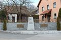
Memorial to the Fallen (2016)

Christmas Tree Farm Kammerer (2016)


literature
- Dieter Bernd: Historical Atlas of Bavaria , part of old Bavaria , issue 39, Vohenstrauß, Munich 1977, ISBN 3-7696-9900-9 .
- Ernst Emmering: The government of the Upper Palatinate, history of a central Bavarian authority , contributions to the history and regional studies of the Upper Palatinate, issue 20, Regensburg 1981.
- Federal Statistical Office (Hrsg.): Historical municipality register for the Federal Republic of Germany. Name, border and key number changes in municipalities, counties and administrative districts from May 27, 1970 to December 31, 1982 . W. Kohlhammer, Stuttgart / Mainz 1983, ISBN 3-17-003263-1 .
- Alois Köppl: From the history of the community of Gleiritsch , 2nd edition, Gleiritsch 1988
- Elisabeth Müller-Luckner: Historical Atlas of Bavaria . Part Altbayern , Heft 50, Nabburg, Munich 1981, ISBN 3-7696-9915-7 .
- Wilhelm Volkert (Ed.): Handbook of Bavarian Offices, Communities and Courts 1799–1980 , CH Beck'sche Verlagsbuchhandlung, Munich 1983, ISBN 3-406-09669-7 .
- Register of the diocese of Regensburg based on the general parish and church description from 1860 , Regensburg 1863.
- Richard Hoffmann, Georg Hager: The art monuments of Upper Palatinate and Regensburg , District Office Vohenstrauss, Munich 1907.
Web links
Individual evidence
- ↑ Alois Köppl, From the history of the community of Gleiritsch, p. 33
- ↑ Elisabeth Müller-Luckner, Historical Atlas of Bavaria, part of Old Bavaria, issue 50, Nabburg, p. 246
- ↑ Dieter Bernd, Historical Atlas of Bavaria, part of Old Bavaria, issue 39, Vohenstrauss, p. 22
- ^ Richard Hoffmann, Georg Hager, Die Kunstdenkmäler von Oberpfalz and Regensburg, District Office Vohenstrauß, p. 19
- ↑ Dieter Bernd, Historical Atlas of Bavaria, part of Old Bavaria, issue 39, Vohenstrauss, p. 54
- ↑ Dieter Bernd, Historical Atlas of Bavaria, part of Old Bavaria, issue 39, Vohenstrauß, p. 72
- ↑ Register of the diocese of Regensburg according to the general parish and church description from 1860, XVI
- ^ Richard Hoffmann, Georg Hager, Die Kunstdenkmäler von Oberpfalz and Regensburg, District Office Vohenstrauß, p. 19
- ^ Richard Hoffmann, Georg Hager, Die Kunstdenkmäler von Oberpfalz and Regensburg, District Office Vohenstrauß, p. 19
- ^ Emmering, Ernst, The Government of the Upper Palatinate, History of a Bavarian Central Authority, Contributions to the History and Regional Studies of the Upper Palatinate, Issue 20, Regensburg 1981, p. 12 ff.
- ↑ Dieter Bernd, Historical Atlas of Bavaria, part of Old Bavaria, issue 39, Vohenstrauss, p. 207
- ↑ Dieter Bernd, Historical Atlas of Bavaria, part of Old Bavaria, issue 39, Vohenstrauss, p. 221
- ^ Wilhelm Volkert (ed.): Handbook of Bavarian offices, communities and courts 1799–1980 . CH Beck, Munich 1983, ISBN 3-406-09669-7 , p. 586 .
- ^ Federal Statistical Office (ed.): Historical municipality directory for the Federal Republic of Germany. Name, border and key number changes in municipalities, counties and administrative districts from May 27, 1970 to December 31, 1982 . W. Kohlhammer, Stuttgart / Mainz 1983, ISBN 3-17-003263-1 , p. 652 .