
Böhmischbruck
|
Böhmischbruck
Vohenstrauß municipality
Coordinates: 49 ° 34 ′ 34 ″ N , 12 ° 21 ′ 5 ″ E
|
||
|---|---|---|
| Height : | 469 m | |
| Residents : | 240 (2011) | |
| Incorporation : | July 1, 1972 | |
| Postal code : | 92648 | |
| Area code : | 09651 | |
Location of Böhmischbruck in Bavaria |
||
 Böhmischbruck (2013)
|
||

Böhmischbruck is a parish village in the northern Upper Palatinate . It is located in the Upper Palatinate Forest in the Pfreimd valley , about six kilometers south of the town of Vohenstrauß , whose district has been Böhmischbruck since 1972.
history
Place names indicate that the Pfreimd valley was first settled by Slavs in the 9th century .
The foundation of the place probably goes back to ministerials of the Counts of Ortenburg , who had a bridge built over the Pfreimd at this point in the 13th century.
Böhmischbruck ("locus pons Boemorum") was first mentioned in 1250 in a deed of donation for the monastery of St. Emmeram in Regensburg . In 1299, the Benedictines founded a monastery in the village, from which the Propstei Böhmischbruck emerged a little later . The location on the left bank of the Pfreimd early served a pre-industrial use of hydropower. A hammer mill has been proven since 1362. In 1431 the place was devastated by the Hussites , on May 5, 1562 a fire destroyed the propstei, church and rectory.
In 1830 the previously independent communities of Altentreswitz (with the districts Grünhammer and Wastlmühle ) and Kößing (with the district Linglmühle ) were incorporated into Böhmischbruck. The Goldbachschleife district was added by 1885 at the latest . In the course of the municipal reform in Bavaria, Böhmischbruck lost its status of an independent municipality on July 1, 1972 and has since been part of the city of Vohenstrauß.
Population development
| year | Residents | building |
|---|---|---|
| 1871 | 312 | 62 |
| 1885 | 112 | 16 |
| 1900 | 289 | 22nd |
| 1928 | 239 | 21st |
| 1950 | 311 | 39 |
| year | Residents | building |
|---|---|---|
| 1961 | 204 | 44 |
| 1970 | 202 | k. A. |
| 1987 | 168 | 52 |
| 2011 | 240 | k. A. |
Attractions
The townscape is shaped by the Catholic parish church of the Assumption from the 18th century. The rectory belonging to the parish on the south side of the church is also listed.
Also characteristic are the numerous wayside crosses in the vicinity of the place, which were created especially in the 18th and 19th centuries and bear witness to the general piety of the people.
Picture gallery

Parish Church of the Assumption
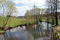
River Pfreimd

Old Catholic rectory

Parish church (interior view)

Böhmischbruck quarry (2015)


Web links
Individual evidence
- ^ Wilhelm Volkert (ed.): Handbook of Bavarian offices, communities and courts 1799–1980 . CH Beck, Munich 1983, ISBN 3-406-09669-7 , p. 586 .
- ↑ https://www.bayerische-landesbibliothek-online.de/landesbeschreibung-orte
- ↑ Kgl. Statistical Bureau (ed.): Complete list of localities of the Kingdom of Bavaria. According to districts, administrative districts, court districts and municipalities, including parish, school and post office affiliation ... with an alphabetical general register containing the population according to the results of the census of December 1, 1875 . Adolf Ackermann, Munich 1877, 2nd section (population figures from 1871, cattle figures from 1873), Sp. 983 , urn : nbn: de: bvb: 12-bsb00052489-4 ( digitized version ).
- ↑ K. Bayer. Statistical Bureau (Ed.): Localities directory of the Kingdom of Bavaria. According to government districts, administrative districts, ... then with an alphabetical register of locations, including the property and the responsible administrative district for each location. LIV. Issue of the contributions to the statistics of the Kingdom of Bavaria. Munich 1888, Section III, Sp. 929 ( digitized version ).
- ↑ K. Bayer. Statistical Bureau (Ed.): Directory of localities of the Kingdom of Bavaria, with alphabetical register of places . LXV. Issue of the contributions to the statistics of the Kingdom of Bavaria. Munich 1904, Section II, Sp. 971 ( digitized version ).
- ↑ Bavarian State Statistical Office (ed.): Localities directory for the Free State of Bavaria according to the census of June 16, 1925 and the territorial status of January 1, 1928 . Issue 109 of the articles on Bavaria's statistics. Munich 1928, Section II, Sp. 989 ( digitized version ).
- ↑ Bavarian State Statistical Office (ed.): Official place directory for Bavaria - edited on the basis of the census of September 13, 1950 . Issue 169 of the articles on Bavaria's statistics. Munich 1952, DNB 453660975 , Section II, Sp. 851 ( digitized version ).
- ↑ Bavarian State Statistical Office (ed.): Official city directory for Bavaria, territorial status on October 1, 1964 with statistical information from the 1961 census . Issue 260 of the articles on Bavaria's statistics. Munich 1964, DNB 453660959 , Section II, Sp. 625 ( digitized version ).
- ^ Bavarian State Statistical Office (ed.): Official place directory for Bavaria . Issue 335 of the articles on Bavaria's statistics. Munich 1973, DNB 740801384 , p. 132 ( digitized version ).
- ↑ Bavarian State Statistical Office (ed.): Official place directory for Bavaria, territorial status: May 1, 1978 . Issue 380 of the articles on Bavaria's statistics. Munich December 1978, DNB 790598426 , p. 125 ( digitized version ).
- ↑ Bavarian State Office for Statistics and Data Processing (Ed.): Official local directory for Bavaria, territorial status: May 25, 1987 . Issue 450 of the articles on Bavaria's statistics. Munich November 1991, DNB 94240937X , p. 266 ( digitized version ).
- ↑ http://atlas.zensus2011.de/

Altenstadt near Vohenstrauss | Altentreswitz | Arnmühle | Binnermühle | Böhmischbruck | Braunetsrieth | Erpetshof | Fiedlbühl | Prince Mill | Gallows Mountain | Goldbach loop | Grünhammer | Hammer | Hartwichshof | Herrnmühle | Polecat mill | Kaimling | Kaltenbaum | Kapplhaus | Kößing | Kößlmühle | Lämersdorf | Linglmühle | Luhmühle | Neumühle | Neuwirtshaus | Oberlind | Obernankau | Top loop | Upper counter field | Paper mill | Rye stone | Street houses | Diving center | Trasgschieß | Übersteherhäusl | Unterlind | Undergrinding | Lower counter field | Vohenstrauss | Waldau | Wastlmühle | Weißenstein | Wiegenhof | Wilhelmshöhe | Zeßmannsrieth | Zieglhütte | Zieglmühle