Braunetsrieth
|
Braunetsrieth
City of Vohenstrauss
Coordinates: 49 ° 37 ′ 1 ″ N , 12 ° 23 ′ 5 ″ E
|
||
|---|---|---|
| Height : | 555 m | |
| Residents : | 65 (May 9, 2011) | |
| Incorporation : | 1830 | |
| Incorporated into: | Burgtreswitz , reclassified to Vohenstrauß in 1949 | |
| Postal code : | 92648 | |
| Area code : | 09651 | |
|
Location of Braunetsrieth in Bavaria |
||
|
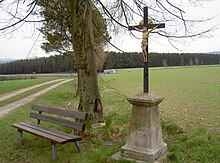
Village chapel in Braunetsrieth
|
||
The village of Braunetsrieth is a district of Vohenstrauß in the Neustadt an der Waldnaab district in the Upper Palatinate .
Place name
The ending -rieth of the place name Braunetsrieth indicates an early development of the place before the 13th century. The places with the place names ending in -reuth, -rieth, -ried, -richt (earlier spelling: -riut, -rivt, -rewt, derived from “clearing”, “clearing”) emerged in connection with the first settlement of the area by clearing the dense forest. Places with such names occur very often in the area of the rivers Pfreimd and Luhe and the adjacent streams. These were the starting point for the settlement of the region.
Geographical location
Braunetsrieth is about 3 kilometers east of Vohenstrauß at the foot of the 611 meter high Steinbühl. The Michlbach rises west of Braunetsrieth. The Fahrnbach rises on the southern outskirts of Braunetsried. Federal motorway 6 runs in an arc south of Braunetsried .
history
In an interest register of 1454 of Pflegamtes Pleystein Braunetsrieth was (formerly: Bruersriet ) named but described as desolate and abandoned. Braunetsrieth belonged to the rule of the Waldauer . In 1483 Braunetsrieth was named when Ulrich von Waldau gave part of his possessions to his sons.
In the middle of the 16th century the rule of the Waldauer - and thus also Braunetsrieth - passed to the Wirsbergers . In 1632 it came into the possession of the Lords of Enkefort . Since the end of the 17th century, the Barons von Rumel held the fiefdom. At the beginning of the 19th century the Barons von Lilien were named as owners of Braunetsrieth.
A book of the Pleystein Office from 1560 named Braunetsrieth with 11 properties, including 6 farms, a dwelling and a shepherd's house. The rule Waldau had 3 teams in Braunetsrieth with manorial rule and lower court. The Altenstadt church, the Floß church and the judge in Vohenstrauss had rights to tithes in Braunetsrieth. In 1596 Braunetsrieth still belonged to the Pleystein nursing office. In the 18th century Braunetsrieth belonged to the fourth quarter of the Pleystein nursing office. In the second half of the 18th century Braunetsrieth had 16 properties, a weaver, a blacksmith and a shepherd's house. The lordship and lower court over Braunetsrieth lay with the Waldau lordship. Braunetsrieth belonged to the Vohenstrauss parish. In 1808, when the tax districts were formed , Braunetsrieth came into the Treswitz tax district (= Burgtreswitz ). The Treswitz tax district included the two villages Braunetsrieth, Treswitz and the wasteland of Pölitzmühl.
In 1809 Braunetsrieth belonged to the Waldau patrimonial court .
Until 1818 Übersteherhäusl was named as part of the municipality of Braunetsrieth.
In 1821 Braunetsrieth became a community with 17 families together with the desert of Weißenstein with 4 families.
In 1830 the municipality of Braunetsrieth was incorporated into the municipality of Burgtreswitz. In 1949 Braunetsrieth and Weißenstein were spun off from the Burgtreswitz community and incorporated into Vohenstrauss.
Population development
| year | Residents | building |
|---|---|---|
| 1871 | 155 | 40 |
| 1885 | 166 | 20th |
| 1900 | 161 | 20th |
| 1928 | 137 | 21st |
| 1950 | 164 | 24 |
| year | Residents | building |
|---|---|---|
| 1961 | 95 | 19th |
| 1970 | 90 | k. A. |
| 1987 | 78 | 19th |
| 2011 | 65 | k. A. |
Culture and sights
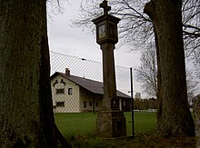
The Braunetsrieth chapel is a listed building. In the area around Braunetsrieth there are numerous old boundary stones, Marterl and a stone cross, some from the 16th century. On November 21, 1977, a Marterlweg was established that touches 17 land monuments . Medieval remains of the historic Nuremberg-Prague military road have been preserved between Braunetsrieth and Oberlind.
literature
- Hans Frischholz, Otto Würschinger: Vohenstrauss through the ages. Local history about the history of the city on the occasion of the 600th anniversary of its first mention. 1378-1978. City of Vohenstrauß, Vohenstrauß 1978, pp. 35–39.
Web links
Individual evidence
- ↑ atlas.zensus2011.de
- ↑ Dieter Bernd: Vohenstrauss . In: Historical Atlas of Bavaria , part of Old Bavaria . Series I, issue 39. Komm. Für Bayerische Landesgeschichte, Munich 1977, ISBN 3-7696-9900-9 , p. 6 ( digitized version ).
- ↑ a b Dieter Bernd: Vohenstrauss . In: Historical Atlas of Bavaria , part of Old Bavaria . Series I, issue 39. Komm. Für Bayerische Landesgeschichte, Munich 1977, ISBN 3-7696-9900-9 , p. 144 ( digitized version ).
- ↑ Dieter Bernd: Vohenstrauss . In: Historical Atlas of Bavaria , part of Old Bavaria . Series I, issue 39. Komm. Für Bayerische Landesgeschichte, Munich 1977, ISBN 3-7696-9900-9 , p. 123 ( digitized version ).
- ↑ Dieter Bernd: Vohenstrauss . In: Historical Atlas of Bavaria , part of Old Bavaria . Series I, issue 39. Komm. Für Bayerische Landesgeschichte, Munich 1977, ISBN 3-7696-9900-9 , p. 124, 202 ( digitized version ).
- ↑ Dieter Bernd: Vohenstrauss . In: Historical Atlas of Bavaria , part of Old Bavaria . Series I, issue 39. Komm. Für Bayerische Landesgeschichte, Munich 1977, ISBN 3-7696-9900-9 , p. 144 f . ( Digitized version ).
- ↑ Dieter Bernd: Vohenstrauss . In: Historical Atlas of Bavaria , part of Old Bavaria . Series I, issue 39. Komm. Für Bayerische Landesgeschichte, Munich 1977, ISBN 3-7696-9900-9 , p. 125, 138 ( digitized version ).
- ↑ Dieter Bernd: Vohenstrauss . In: Historical Atlas of Bavaria , part of Old Bavaria . Series I, issue 39. Komm. Für Bayerische Landesgeschichte, Munich 1977, ISBN 3-7696-9900-9 , p. 147 ( digitized version ).
- ↑ Dieter Bernd: Vohenstrauss . In: Historical Atlas of Bavaria , part of Old Bavaria . Series I, issue 39. Komm. Für Bayerische Landesgeschichte, Munich 1977, ISBN 3-7696-9900-9 , p. 211 ( digitized version ).
- ↑ Dieter Bernd: Vohenstrauss . In: Historical Atlas of Bavaria , part of Old Bavaria . Series I, issue 39. Komm. Für Bayerische Landesgeschichte, Munich 1977, ISBN 3-7696-9900-9 , p. 202 ( digitized version ).
- ↑ a b Dieter Bernd: Vohenstrauss . In: Historical Atlas of Bavaria , part of Old Bavaria . Series I, issue 39. Komm. Für Bayerische Landesgeschichte, Munich 1977, ISBN 3-7696-9900-9 , p. 220 ( digitized version ).
- ↑ Dieter Bernd: Vohenstrauss . In: Historical Atlas of Bavaria , part of Old Bavaria . Series I, issue 39. Komm. Für Bayerische Landesgeschichte, Munich 1977, ISBN 3-7696-9900-9 , p. 215 ( digitized version ).
- ↑ https://www.bayerische-landesbibliothek-online.de/landesbeschreibung-orte
- ↑ Kgl. Statistical Bureau (ed.): Complete list of localities of the Kingdom of Bavaria. According to districts, administrative districts, court districts and municipalities, including parish, school and post office affiliation ... with an alphabetical general register containing the population according to the results of the census of December 1, 1875 . Adolf Ackermann, Munich 1877, 2nd section (population figures from 1871, cattle figures from 1873), Sp. 984 , urn : nbn: de: bvb: 12-bsb00052489-4 ( digitized version ).
- ↑ K. Bayer. Statistical Bureau (Ed.): Localities directory of the Kingdom of Bavaria. According to government districts, administrative districts, ... then with an alphabetical register of locations, including the property and the responsible administrative district for each location. LIV. Issue of the contributions to the statistics of the Kingdom of Bavaria. Munich 1888, Section III, Sp. 930 ( digitized version ).
- ↑ K. Bayer. Statistical Bureau (Ed.): Directory of localities of the Kingdom of Bavaria, with alphabetical register of places . LXV. Issue of the contributions to the statistics of the Kingdom of Bavaria. Munich 1904, Section II, Sp. 972 ( digitized version ).
- ↑ Bavarian State Statistical Office (ed.): Localities directory for the Free State of Bavaria according to the census of June 16, 1925 and the territorial status of January 1, 1928 . Issue 109 of the articles on Bavaria's statistics. Munich 1928, Section II, Sp. 989 ( digitized version ).
- ↑ Bavarian State Statistical Office (ed.): Official place directory for Bavaria - edited on the basis of the census of September 13, 1950 . Issue 169 of the articles on Bavaria's statistics. Munich 1952, DNB 453660975 , Section II, Sp. 851 ( digitized version ).
- ↑ Bavarian State Statistical Office (ed.): Official city directory for Bavaria, territorial status on October 1, 1964 with statistical information from the 1961 census . Issue 260 of the articles on Bavaria's statistics. Munich 1964, DNB 453660959 , Section II, Sp. 630 ( digitized version ).
- ^ Bavarian State Statistical Office (ed.): Official place directory for Bavaria . Issue 335 of the articles on Bavaria's statistics. Munich 1973, DNB 740801384 , p. 132 ( digitized version ).
- ↑ Bavarian State Office for Statistics and Data Processing (Ed.): Official local directory for Bavaria, territorial status: May 25, 1987 . Issue 450 of the articles on Bavaria's statistics. Munich November 1991, DNB 94240937X , p. 266 ( digitized version ).
- ↑ http://atlas.zensus2011.de/
- ↑ Dieter Bernd: Vohenstrauss . In: Historical Atlas of Bavaria , part of Old Bavaria . Series I, issue 39. Komm. Für Bayerische Landesgeschichte, Munich 1977, ISBN 3-7696-9900-9 , p. 8 ( digitized version ).


