Wadrill roof slate pit
| Wadrill roof slate pit | |||
|---|---|---|---|
| General information about the mine | |||
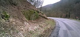
| Wadrill roof slate pit on the L 150, walled up entrance portal. Facing south; 2016 | |||
| Mining technology | Underground mining | ||
| Information about the mining company | |||
| Operating company | STEGRONI GmbH - Mines d'ardoises de la Sarre, Wadrill (last) | ||
| Start of operation | 1520s | ||
| End of operation | 1953 | ||
| Successor use | possible refuge for bats | ||
| Funded raw materials | |||
| Degradation of | Roofing slate | ||
| Mightiness | 60 m | ||
| Greatest depth | 40 m | ||
| Greatest depth | 30 m | ||
| overall length | 80 m | ||
| Geographical location | |||
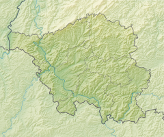
| Coordinates | 49 ° 35 '37 " N , 6 ° 52' 25" E | ||
|
|||
| Location | Wadrill | ||
| local community | Wadrill | ||
| District ( NUTS3 ) | Merzig-Wadern | ||
| country | State of Saarland | ||
| Country | Germany | ||
The Wadrill roof slate pit is located in an inner curve on state road 150 between Wadrill and Grimburg in Saarland, a good kilometer south of the state border with Rhineland-Palatinate . It is the only roof slate pit in Saarland and has been proven to have been exploited from the 1520s to probably 1953. It was in 1978/79 as part of the planning for the never built dam Wadrill last time traveled and bricked in the first half of the 1979th The Wadrilltal was preserved in its original state.
The rock mountain ( 537.2 m above sea level ), formed here as a circulating mountain , is washed around on its west side at about 330 meters above sea level by the Wadrill flowing south . The road runs parallel to the river and a path of minor importance on the opposite bank. About 50 meters northeast of the tunnel mouth , which is still clearly visible today , there was another, the so-called “lower” entrance, which was filled in after the last drive.
history
The oldest evidence of the existence of the Wadrill roof slate pit can be found for the activity of a ley decker at the gate house of Dagstuhl Castle . The delivery of 12 Reiss Leyen was specified for the invoice amount of 2 guilders and 13 Albus . Leyen or loan is the common name for slate slabs in the high forest . According to sources, mining stopped in the 17th century. The protocol exists "The Leyenbrüche to Wadrill particular alleged by the Probstey St. Paulin right to grant the concession and terms of tithing," which from 1793 Berechtsame controls. Various witnesses testified to Pauline Meier von Wadrill that 40 or 50 years ago, with the provost's permission, the Leyenkaul had been in the business. The church received her tithe for this. The log also shows that 20 years earlier , the smelter Nacher from Bierfeld had more than 200 Reiss Leyen mined and only paid tithing to St. Paulin, but not to the Grimburger Kellnerei. Nacher dutifully paid tithes of the Eisenstein he had sponsored to the Grimburg winery. The provost of St. Paulin was right to grant the concession to 'break the ley'. This protocol also mentions an order from Franz Georg von Schönborn from 1743, who granted the citizens of Wadrill the right to “clear the Leyenkaule, which was already dilapidated at that time, at their own expense, subject to the additional condition that the monthly period, thus the beginning made, and the tenth Reis Leyen, under the supervision of the local Paulinischer Mayer, should be charged to the Probsteilichen Kellnerey. “In the parish register there is also talk of an ore find. However, it was probably only a very small amount. The results of a melting test that has taken place are not recorded. In addition, this material would have fallen under the sovereign mountain shelf and no such entry can be proven in the records of Kurtrier .
The out carrying the conveyed material on the back was a very difficult job and was banned 1890th The promotion was now carried out by hand- pushed carts . At the end of the 19th century there were no longer any authorized persons. A profile drawing of the tunnel taken by Markscheider Kehsler has been preserved from this period . This shows the place where explosives are to be stored. The associated application for a permit was granted on January 11, 1898. Another crack from 1921 shows the conditions underground on a scale of 1: 500.
After the Second World War, the mine was reopened in 1947, this time as "STEGRONI GmbH - Mines d'ardoises de la Sarre, Wadrill", an exploration subsidiary of Stegroni AG. The mouth hole, which is still visible today, dates from this time. The slate was considered to be of particularly high quality because of its smooth surface, but it had many fissures and inclusions made of quartzite , so that the yields were not very productive. Stegroni AG went bankrupt in the early 1950s.
The last workers did the dismantling themselves for a short time . But in mid-April 1953 the excavation chamber was buried during a blast because the hanging wall did not hold up. The work continued until the following winter and a new transverse tunnel was dug , but operations finally came to a standstill. Participation in the Saar fair in May 1954 cannot be proven. The landowner is still the Wadrill homestead.
Regional geology
The Felsenberg with the roof slate pit Wadrill is located in the southwest of the Hunsrück , that is, in the Variscan folded Paleozoic of the Rhenish Slate Mountains . It is located on the southern edge of the slate mountains, only about 1.5 km north of the transition into the unfolded variscid molasse of the Saar-Nahe depression . The most Felsenberg pending and the mine disrupted marine shale come from the oldest stage of the Devonian , the Lochkovian what the regional Gedinne level corresponds. It is lithostratigraphically to the so-called Colored slate or Züscher slate . The slates are colored green or gray and interspersed with layers of sandstone. The bright colors indicate a high degree of oxygen mixing and thus, together with the sandstone layers, indicate relatively shallow water depths or a relative proximity to the coast of the deposit area. However, the slates are very low in fossils, so that the classification in mind cannot be considered completely secure. During the construction of the A 1 autobahn in the second half of the 1960s, the colorful slates were also opened up on a large scale in nearby Nonnweiler- Bierbach. They go north and south into the Hermeskeiler layers (also Hermeskeilschiefer ) over. In these, the proportion of sandstone increases and the bright colors disappear.
Mine buildings, mining methods and structural geological features
“Due to the steep to vertical storage (60 ° –90 °), the slate blocks had to be extracted in the roof joint . In the mining chambers, the slate blocks were wedged off from bottom to top by notches or by a gentle, pushing extraction shot with black powder . The blocks obtained in this way were broken down underground by splitting parallel to the cleavage (tearing) or splitting perpendicular to the cleavage (heads) into extractable blocks. "
The last geological survey of the pit took place in 1978, because the planning for the construction of the Wadrill dam had started a little above the Wadrill. The tectonics at this narrow valley should be investigated. The task was to determine fissures, fractures and faults. The investigations were carried out by the State Office for Water Management and Waste Disposal (LWA) in Saarbrücken. The contractor was the engineering office Lahmeyer in Frankfurt. The Clemens / Brebach and Preussag / Darmstadt working group was responsible for the exploration drilling .
The inspection of the two tunnel systems began on November 21, 1978 and was carried out by Messrs Hermann and Dr. Schetelig documented. The newer tunnel is designated with Schieferstollen I and consists of the now walled up tunnel mouth hole, the following, about 120 meters long, drilled uphill across the strike , and three larger excavation chambers, which were driven approximately one above the other, northeast of the cross passage. The three mines are located at 338 m above sea level, 344 m above sea level and 350 m above sea level, the lower level being accessible via a ramp, but usually under water.
The middle breakdown was the most important. It is on the same level as the main tunnel. Due to the collapse of the hanging wall, this mining is now only accessible via the lower chamber. The upper quarry is no longer accessible and was only discovered because an eruption of the almost horizontally stored slate material was visible. Using a 30 mm - core drilling of the cavity could be confirmed. Accordingly, no statement has been made about its extent. Another, fourth chamber is conceivable.
The three mines lying one on top of the other became necessary due to the almost vertical layer of slate. They are about 40 meters long and four to eight meters wide. Their clear height is between four and five meters. The ceiling between the stopes are according to the report to be extremely weak and therefore the danger of collapse, especially since they are interrupted by shafts and risers and are hardly supported even by mountain pillars.
The Schieferstollen II , also called Josefsstollen , is about 100 meters north, up the valley from the Schieferstollen I. The portal has collapsed completely. This zone has been cleared for traffic. Behind it was a well-preserved piece of tunnel about 15 meters long, which ended in a polygonal excavation chamber about eight meters in diameter. Two, maybe three tunnels branch off from this chamber. The ceiling of this extraction chamber was about four to five meters high; the current ceiling is about seven to eight meters above the sole . A section of the tunnel points in the direction of the slate tunnel I, but is under water. It was suspected, but not further investigated, that this could have been the connecting tunnel to the newer Slate I described above.
literature
- Edgar Schwer: The Wadrill roof slate pit. In: Journal for the history of the Saar region , vol. 60, Krüger, Dillingen 2012, ISBN 978-3-9814952-9-4
- Hans Schwendler: The only roof slate pit in the Saarland. The slate is extracted underground between Wadrill and Grimburg. Saarbrücker Zeitung, undated, Dr. Gerd Müller, Saarbrücken-Scheidt .
Individual evidence
- ↑ Map services of the Federal Agency for Nature Conservation ( information )
- ↑ On the smelter Nacher cf. Edgar Schwer: Hochwälder Hefte zur Heimatgeschichte , 28 years, issue 47: The ore mining in the front high forest 1815–1870 , Nonnweiler 2011, p. 37
- ↑ a b c d e f Edgar Schwer: The roof slate pit Wadrill. In: Journal for the History of the Saar Region , Vol. 60, 2012


