
Despetal
|
Despetal
City of Gronau (Leine)
|
||
|---|---|---|
 |
||
| Height : | 165 m above sea level NHN | |
| Area : | 15 km² | |
| Residents : | 1237 (Dec. 31, 2015) | |
| Population density : | 82 inhabitants / km² | |
| Incorporation : | November 1, 2016 | |
| Postal code : | 31028 | |
| Primaries : | 05065, 05182 | |
Location of Despetal in Lower Saxony |
||
 Location of the former municipality of Despetal in the Hildesheim district
|
||

Despetal was a municipality in the district of Hildesheim , Lower Saxony ( Germany ). She belonged to the joint community of Gronau (Leine) .
geography
Geographical location
The former municipality of Despetal is located southwest of Hildesheim and east of Gronau between the Weser Uplands nature park in the west and the somewhat distant Harz in the east. Immediately northeast of the former municipality is the Hildesheim Forest , south of it the Seven Mountains .
Rivers
The Despe , an eastern tributary of the Leine, flows through the former Despe Valley . There are also the Hahmbach in Eitzum and the Zitterbach and the Hufzitterbach in Barfelde . The Hahmbach and the Hufzitterbach flow into the Despe. The Zitterbach flows into the Hufzitterbach. There are also other bodies of water, some without a name and not always water-bearing.
Community structure
The municipality of Despetal consisted of these three districts:
These districts are now districts of the city of Gronau.
history

Despetal was founded on March 1, 1974 through the merger of the communities of Barfelde, Eitzum and Nienstedt. On November 1, 2016, the community was incorporated into the enlarged city of Gronau (Leine) . Despetal belonged to the joint community of Gronau (Leine) . A memorial with the coats of arms of Eitzum, Barfelde and Nienstedt commemorates the foundation of the Despetal community in 1974.
Some time ago, the municipality of Gronau (Leine) was looking for areas that could be used for wind energy. Despetal, the area favored by the municipality, is located between the villages of Heinum , Eitzum and Eberholzen . There are citizens' movements who oppose the plans because they consider the planned area too small and fear that the wind turbines would have to be very close to the built-up area.
politics
Municipal council
The last municipal council from Despetal consisted of three councilors and seven councilors from the following parties:
- SPD : 6 seats
- CDU : 2 seats
- Greens : 1 seat
- Independent : 1 seat
(As of: local election on September 11, 2011)
mayor
As the last honorary mayor , Andreas Zastrow (SPD) was in office from November 14, 2011 to October 31, 2016. His deputies were Werner Nolte (SPD) and Oliver Schmidt (CDU).
coat of arms
The former rural community Despetal By order of the Council of 20 September 1974, the municipal coat of arms (then a district of Despetal ab) acquired the former church Barfelde. The coat of arms was awarded years earlier on May 17th, 1938 by the President of the Province of Hanover and presented by the District Administrator from Alfeld on July 4th of the same year.
|
|
Blazon : "A black ten-end deer antler on a gold shield ." |
| Foundation of the coat of arms: In the Middle Ages, the Barfelde community was home to the "de Bervelde" family, which had a stag or stag head in its seal. Based on this model, the municipality of Barfelde decided to use the coat of arms described. |
Culture and sights
Buildings
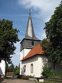
Ev. Church in Eitzum
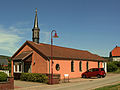
St. Joseph Chapel in Eitzum

Ev. Church in Nienstedt

Barfelde Church


traffic
- Despetal is connected to the road network via country roads with federal roads 3 and 1 .
- The Hanover – Göttingen railway line runs through the area of the joint municipality of Gronau (Leine). The next train station is in Banteln .
- Every working day, Eitzum and Nienstedt are connected to Alfeld and Hildesheim by bus services via Sibbesse .
literature
- Ernst August Strüber (text), Martin Klauss (photos): Despetal then and now. Contributions to the history of Barfelde, Eitzum and Nienstedt. Ed .: Community Despetal, Harsum: Druckhaus Köhler, 361 pages with numerous illustrations, (undated, 2012?), ISBN 978-3-938385-44-9 .
Web links
Individual evidence
- ↑ a b municipalities in Germany by area, population and postcode. (XLS; 4.4 MB) → See under: No. 1756 . In: Destatis website. Federal Statistical Office , December 31, 2015, accessed on June 11, 2019 .
- ↑ Despetal. In: Google Maps website. Retrieved June 11, 2019 .
- ^ Federal Statistical Office (ed.): Historical municipality directory for the Federal Republic of Germany. Name, border and key number changes in municipalities, counties and administrative districts from May 27, 1970 to December 31, 1982 . W. Kohlhammer, Stuttgart / Mainz 1983, ISBN 3-17-003263-1 , p. 204 .
- ↑ Lower Saxony State Chancellery (Ed.): Law on the unification of the communities of Banteln, Betheln, Brüggen, Despetal, Rheden and the city of Gronau (Leine) as well as on the new formation of the Duingen area and the Leinebergland community, Hildesheim district . Lower Saxony Law and Ordinance Gazette (Nds. GVBl.). No. 22/2015 . Hanover December 15, 2015, p. 399-400 ( digitized [PDF; 278 kB ; accessed on June 29, 2019] pp. 17–18).
- ↑ a b The council of the municipality Despetal. In: Website of the Samtgemeinde Gronau (Leine). Retrieved September 20, 2017 .
- ^ A b Wilhelm Barner : Coat of arms and seal of the Alfeld district . Rebinding. Lax GmbH & Co. KG, Hildesheim 1998 ( digitized version of the text part of the first edition from 1940 [PDF; 10.0 MB ; accessed on June 10, 2019]).
- ↑ a b Description of the coat of arms of the municipality of Despetal / Barfelde. (PDF; 46 KB) In: Website of the Samtgemeinde Gronau (Leine). Retrieved June 10, 2019 .
.png)
Dumbbells | Barfelde | Betheln | Brüggen | Dötzum | Eddinghausen | Eitzum | Gronau (Leine) | House Escherde | Heinum | Nienstedt | Rheden | Wallenstedt