Andahuaylas district
| Andahuaylas district | |||
|---|---|---|---|
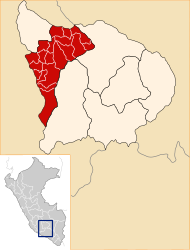
 The Andahuaylas district is located in the north of the Andahuaylas province (marked in red) |
|||
| Symbols | |||
|
|||
| Basic data | |||
| Country | Peru | ||
| region | Apurímac | ||
| province | Andahuaylas | ||
| Seat | Andahuaylas | ||
| surface | 197 km² | ||
| Residents | 43,560 (2017) | ||
| density | 221 inhabitants per km² | ||
| founding | June 21, 1825 | ||
| ISO 3166-2 | PE-APU | ||
| Website | muniandahuaylas.gob.pe (Spanish) | ||
| politics | |||
| Alcalde Provincial | Abel Gutiérrez Huezo (2019-2022) |
||
| Political party | Movimiento Regional Llankasun Kuska | ||
| View of the city of Andahuaylas | |||
Coordinates: 13 ° 39 ′ S , 73 ° 23 ′ W
The Andahuaylas district is located in the Andahuaylas province in the Apurímac region in south-central Peru . The district was established on June 21, 1825. On December 15, 2014, the south-eastern part of the district was separated and has since formed the newly founded José María Arguedas district .
It has an area of 197 km². The 2017 census counted 43,560 inhabitants. The district administration is located in the provincial capital Andahuaylas at 2926 m high with 35,500 inhabitants (as of 2017).
Geographical location
The Andahuaylas district is located in the Andean highlands in the north of the Andahuaylas province. The Chumbao River crosses the north of the district in a westerly direction.
The Andahuaylas district borders on the Tumay Huaraca , Turpo and Talavera districts in the west, the Pacucha district in the extreme north, the San Jerónimo district in the northeast, the José María Arguedas district in the southeast and the Colcabamba district ( Aymaraes province) in the south ).
Web links
- Municipalidad Provincial de Andahuaylas
- Peru: Region Apurímac (provinces and districts) at www.citypopulation.de


