Pacucha District
| Pacucha District | |
|---|---|
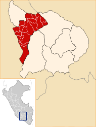
 The Pacucha district is located in the north of the Andahuaylas province (marked in red) |
|
| Basic data | |
| Country | Peru |
| region | Apurímac |
| province | Andahuaylas |
| Seat | Pacucha |
| surface | 170 km² |
| Residents | 8681 (2017) |
| density | 51 inhabitants per km² |
| founding | August 21, 1963 |
| ISO 3166-2 | PE-APU |
| Website | munipacucha.gob.pe (Spanish) |
| politics | |
| Alcalde District | Hainor Luis Navarro Huamán (2019-2022) |
| View over the lake Laguna Pacucha | |
Coordinates: 13 ° 37 ′ S , 73 ° 21 ′ W
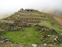
The Pacucha district is located in the Andahuaylas province of the Apurímac region in south-central Peru . The district was established on August 21, 1963. It has an area of 170 km². At the 2017 census, there were 8,681 residents in the district. In 2007 the population was 9,841. The district administration is located in the 3125 m high village of Pacucha with 1114 inhabitants (as of 2017). Pacucha is located on the west bank of the lake Laguna Pacucha , 7 km northeast of the provincial capital Andahuaylas . To the east of the Laguna Pacucha is the archaeological site of Sóndor.
Geographical location
The Pacucha district is located in the Andean highlands in the north of the Andahuaylas province. The 7.3 km² large lake Laguna Pacucha is centrally located in the district. The main tributary of the Laguna Pacucha, the Quebrada Argama, and its outflow, the Quebrada Tocsama, flow through the district in a west-northwest direction.
The Pacucha district is bordered to the west by the district Talavera , on the north by the districts Andarapa and Kaquiabamba , on the east by the district Kishuara , the south by the district of San Jeronimo and in the extreme southwest of the district Andahuaylas .
Localities
In addition to the main town of Pacucha, there are the following larger towns in the district:
- Anccopaccha (383 inhabitants)
- Argama Alta (541 inhabitants)
- Argama Bajo (448 inhabitants)
- Cotahuacho Alto (259 inhabitants)
- Jose Olaya (329 inhabitants)
- Manchaybamba (557 inhabitants)
- Manzanapata (236 inhabitants)
- Santa Elena (348 inhabitants)
- Santa Rosa (243 inhabitants)
- Villa Esperanza Cotahuacho Bajo (314 inhabitants)
Web links
- Municipalidad Distrital de Pachucha
- Peru: Region Apurímac (provinces and districts) at www.citypopulation.de

