Kaquiabamba District
| Kaquiabamba District | |
|---|---|
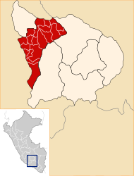
 The Kaquiabamba district is located in the far north of the Andahuaylas province (marked in red) |
|
| Basic data | |
| Country | Peru |
| region | Apurímac |
| province | Andahuaylas |
| Seat | Kaquiabamba |
| surface | 112 km² |
| Residents | 1876 (2017) |
| density | 17 inhabitants per km² |
| founding | June 9, 1995 |
| ISO 3166-2 | PE-APU |
| politics | |
| Alcalde District | Juan Rosel Pacheco Laura (2019-2022) |
| Political party | Avanza País |
Coordinates: 13 ° 32 ′ S , 73 ° 17 ′ W
The Kaquiabamba district is located in the Andahuaylas province of the Apurímac region in south-central Peru . The district was formed on June 9, 1995 from parts of Pacucha District .
The district extends over an area of 112 km². At the 2017 census there were 1,876 residents in the district. In 2007 the population was 2,410. The district administration is located in the 3150 m high village of Kaquiabamba with 674 inhabitants (as of 2017). Kaquiabamba is just 18 km northeast of the provincial capital Andahuaylas .
Geographical location
The Kaquiabamba district is located in the Andean highlands in the far north of the Andahuaylas province. It has a longitudinal extent in the NNW-SSE direction of almost 17 km and a maximum width of almost 10 km. The lower reaches of the Río Pampas runs along the northern district boundary to the east. Its right tributary Río Pincos flows in parts along the eastern district border to the north.
The Kaquiabamba district is bordered to the west by the district Andarapa , on the north by the district Oronccoy ( province of La Mar ), on the east by the district Pacobamba and in the south to the district Pacucha.
Web links
- Peru: Region Apurímac (provinces and districts) at www.citypopulation.de
