Huancaray District
| Huancaray District | |
|---|---|
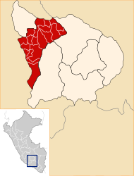
 The Huancaray district is located in the west of the Andahuaylas province (marked in red) |
|
| Basic data | |
| Country | Peru |
| region | Apurímac |
| province | Andahuaylas |
| Seat | Huancaray |
| surface | 111 km² |
| Residents | 3965 (2017) |
| density | 36 inhabitants per km² |
| founding | January 7, 1961 |
| ISO 3166-2 | PE-APU |
| Website | munihuancaray.gob.pe (Spanish) |
| politics | |
| Alcalde District | Luciano Huaraca Gutiérrez (2019-2022) |
| Political party | Movimiento Regional Llankasun Kuska |
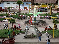
| Plaza de Armas in Huancaray | |
Coordinates: 13 ° 45 ′ S , 73 ° 32 ′ W
The Huancaray district is located in the Andahuaylas province in the Apurímac region in south-central Peru . The district was established on January 7, 1961. It has an area of 111 km². The 2017 census counted 3965 inhabitants. In 1993 the population was 4583, in 2007 it was 4387. The district administration is located in the 2902 m high village of Huancaray with 452 inhabitants (as of 2017). Huancaray is located about 19 km southwest of the provincial capital Andahuaylas .
Geographical location
The Huancaray district is located in the Andean highlands in the west of the Andahuaylas province. The Río Huancaray, right tributary of the Río Pampas , crosses the district in a west-northwest direction.
The Huancaray district borders on the San Antonio de Cachi district to the west, the Santa María de Chicmo district to the north, the Turpo district to the east and the Tumay Huaraca and Chiara districts to the south .
Web links
- Municipalidad Distrital de Huancaray
- Peru: Region Apurímac (provinces and districts) at www.citypopulation.de
