
Eastern (Kenya)
| Eastern | |
|---|---|
  |
|
| Basic data | |
| Capital | Embu |
| surface | 154,354 km² |
| Residents | 5,456,190 (official estimate 2008) |
| Population density | 35 inhabitants per km² |
| ISO 3166-2 | KE-400 (repealed) |
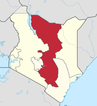
Eastern ( East ) was a province of Kenya . Their capital was Embu .
The province had about 5.5 million inhabitants. The inhabitants in the more densely populated southern part of Eastern belonged mainly to the Bantu-speaking ethnic groups of the Kamba , Kikuyu , Meru and Embu . In the sparsely populated northern part lived Cushitic-speaking pastoral nomads, mostly Borana ( Oromo ), next to them the Gabbra, allied with them, as well as Rendille and Somali .
The Eastern Province included the Chalbi Desert , Mount Kenya and the eastern half of Lake Turkana . In the north, the province bordered Ethiopia .
In the northern part, droughts were a problem and resulted in great dependence on food aid .
As part of the 2010 constitution , the Kenyan provinces were dissolved. The counties Embu , Isiolo , Kitui , Machakos , Makueni , Marsabit , Meru and Tharaka-Nithi are located in the Eastern Province .
Administrative division
Eastern was divided into 13 districts:
| District | Capital |
|---|---|
| Embu | Embu |
| Isiolo | Isiolo |
| Kitui | Kitui |
| Machakos | Machakos |
| Makueni | Wote |
| Marsabit | Marsabit |
| Mberry | Siakago |
| Meru Central | Meru |
| Meru North / Nyambene | Maua |
| Meru South / Nithi | Chuka |
| Moyale | Moyale |
| Mwingi | Mwingi |
| Tharaka | Tharaka |
Individual evidence
- ↑ bevölkerungsstatistik.de (2008)
Central | Coast | Eastern | Nairobi | North-Eastern | Nyanza | Rift Valley | Western film
Coordinates: 0 ° 0 ′ N , 38 ° 0 ′ E