
Cold desert
| Cold desert | |
 Cold desert on Huey Creek, a meltwater river in the Antarctic dry valleys |
|
| Area share | approx. 2% of the land surface |
| Ecological condition | ~ 85% original wilderness > 10% largely near-natural |
| Land use | ./. |
| biodiversity | extremely low (200–600 species per hectare) |
| Biomass | extremely low (less than 2 t / ha dry matter) |
| Representative large protected areas (only IUCN Ia, Ib, II , NP , WE and PP ) |
Quttinirpaaq (CAN) 37,775 km 2 Russian Arctic (RUS) 14,260 km 2 |
|
Climatic conditions
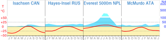  Cold desert : climate diagrams |
|
| Exposure to sunlight | <800–1100 kWh / m 2 / a (for the zone) |
| Ø temperatures |
Coldest month: below 0 to below −50 ° C Annual mean: below −30 to below 0 ° C Warmest month: below −10 to above 5 ° C |
| Annual precipitation | below 100–200 mm (9–12 months of snow) |
| Water balance | nival ( humid ) |
| Growing season | under 30 days |
Cold desert (also frost rubble desert or area ) is the generic term for the almost vegetation-free areas of the polar climatic zone that are not permanently covered by ice and snow. The term comes from geography and generally designates a certain type of landscape on the global scale . There are different definitions depending on the discipline, see section “Definition” .
Characteristic for the different forms of the cold desert is an open, stony or sandy and for the most part almost vegetation-free landscape over permafrost . In many cases, the lichen crusts on the rocks are the only living things that can be seen. Mosses and grasses also predominantly occur in protected areas .
definition
From the perspective of Geobotany (Pflanzengeographie) the cold desert is a natural vegetation type , which especially under the conditions of Eisklimas arises. In their erdumspannenden ( geozonalen ) expansion the cold desert is among the vegetation zones . In addition, comparable plant formations occur worldwide in the altitude levels of the mountains, which can be assigned to the cold deserts as non- zonal vegetation types .
From an ecological point of view , the cold desert is one of the largest possible (abstract) ecosystems that together form the biosphere . It itself is formed from typical biomes or ecoregions , which in turn are composed of the associated small-scale (specific) biotopes and ecotopes . These in turn subdivide the Earth-encompassing polar zonobiom or the polar / subpolar ecozone .
From a biogeographical point of view, the ice deserts ( ice sheets and glaciers ) of the earth are not counted as cold deserts, since no more plants and animals can live here.
Spread and condition
The northern (arctic) vegetation zone of the cold desert extends in its maximum extent from about 83 ° north latitude ( Cape Morris Jesup on Greenland ) to 66 ° (at the Arctic Circle on Baffin Island ). The southern (Antarctic) zone extends from 85 ° south latitude (ice-free peaks of the Transantarctic Mountains ) to around 63 ° (on the Antarctic peninsula Grahamland ). Due to the few land areas in the southern hemisphere, the cold desert there only makes up a small part of the total area. The cold deserts merge towards the poles into the zone of ice sheets and towards the equator into the tundras .
The non-zonal alpine cold deserts occur worldwide in almost all high mountains above the Matten, where they are referred to as the nival altitude level.
The largest undestroyed cold deserts on earth are on the Queen Elizabeth Islands of Canada. In the Tibetan highlands , the largest areas are outside the polar zone.
In relation to the potential natural vegetation , around 2% of the earth's land surface are cold deserts today. In fact, at the beginning of the 3rd millennium, around 85% of the cold deserts are in a largely unaffected, natural state . These areas are unpopulated. Over 10% are still close to nature and have relatively little influence. These areas are mainly in the vicinity of coastal settlements or in high mountains. Less than 5% were intensively changed and overprinted by anthropogenic landscapes .

Characteristic
Cold deserts are areas in the transition from the tundra to the ice deserts that have less than 10% but more than 1% plant cover. The year-round frozen permafrost prevents roots from penetrating and the air temperature is so cold that plant growth is significantly restricted. Therefore, there are only very limited habitats for animals . Another characteristic of the polar cold deserts are dry air and strong winds ( blizzards ). Due to the lack of protection of a plant cover or the resulting humus layer , the icy temperatures cause so-called frost weathering of the rocks. The product is called "frost debris".
Ice deserts

Around nine percent of the earth's land surface lies under an ice sheet that limits the ice-free cold deserts. 16% of this is in the Greenland Ice Sheet. The largest ice desert on earth is Antarctica , which makes up around 83% of it. It is extremely dry in the Antarctic inland because the cold air can only absorb very little moisture. Precipitation often falls on the Antarctic coasts and no longer reaches the central areas. The ice sheets located there often only receive a very thin layer of new ice each year, which is why thicker ice accumulations in depressions often consist of very old ice. Drifts and sublimation of ice rarely lead to open, ice-free desert landscapes consisting of fields of frost rubble or rocky soil without vegetation . These areas are called " Antarctic dry valleys ".
In all mountainous ice deserts so-called Nunatakker occur; Mountain peaks that protrude over the ice. As a habitat for lichens and algae, both the Nunatakker and the Antarctic dry valleys are in turn assigned to the cold deserts.
Climatic conditions
The cold deserts of the earth are in the polar climate zone and are therefore usually characterized by very cold climates with long, cold winters and short, cold summers. In the coldest month, the average temperatures generally do not rise above 0 ° C ; where the minimum is below −50 ° C. There is snow for nine to twelve months. The warmest month is hardly above +5 ° C on average; in some cases the temperature remains below −10 ° C even in summer. Nevertheless, maximum temperatures of +20 ° C are possible even in these high latitudes. The long-term average temperature is between −30 ° C and generally below 0 ° C. For the polar cold deserts, there is also a very low level of solar radiation , which makes it difficult for plants to grow , but in midsummer this is caused by the midnight sun, for example. T. is compensated .
With averages below 100–200 mm, the total annual rainfall is low to very low. Since they almost exclusively fall as snow, the climate is also known as nival . The long frost period and the low temperatures lead to a low evaporation rate , so that the water balance on the ground is humid despite the low amounts of precipitation .
The growing season is very short with less than 30 days.
According to the effective climate classification of Köppen / Geiger, one speaks of the so-called ice climate (abbreviation: EF) for the aforementioned conditions .
Other features
In the cold deserts, the very poor soil formation on rock and sand mostly remains in raw soil stages .
The cold deserts are deserts in the narrowest sense - almost lifeless frost debris deserts, which mostly consist of gravel and rubble. Typical of the transition area to the tundras is the restless ground relief that is often characterized by knolls and hollows or walls arranged like a net or ring. These are so-called frost pattern floors . Essentially, the short-term thawing and thawing of the ground above the permafrost, which takes place every year, leads to these unusual structures.
Due to the abiotic factors mentioned above , the amount of biomass available is extremely low (less than 2 t / ha dry matter).
flora
Northern hemisphere
Only 0.4% of all vascular plants on earth live in the Arctic. In addition, the distribution of almost all species living there is not limited to the polar regions. Plant density and diversity decrease towards the poles. In the cold desert, the mosses and a few flowering plants of the isolated, island-like locations remain small (2–5 cm) and do not form a coherent network of roots. Such locations arise, for example, in parabolic depressions, the shape of which bundles the incident solar radiation. Two typical flowering plants that can be found right up to the edge of the ice sheets are the opposed saxifrage and the arctic poppy . The dominant forms of life in the cold desert, however, are algae and lichens - symbiotic communities of green algae and fungi. Lichen are absolutely frost hardy. The crusty lichens, which live on stones and form extremely hard patterns, often reminiscent of maps ( map lichen ), remain photosynthetically active even at sub-zero temperatures . On rock, lichens are important pioneering organisms that either sit on the rock or even penetrate the stone.
Southern hemisphere
Before humans brought in a handful of neophytes , only two flowering plants grew in the whole of Antarctica : the Antarctic Schmiele ( Deschampsia antarctica ) and the clove plant Antarctic Perlwort ( Colobanthus quitensis ). The vast majority of the Antarctic cold desert is devoid of vegetation apart from a few lichens. The number of lichen species is significantly lower here than in the Arctic.
fauna
The fauna of the cold deserts is far more sparse than the flora and is particularly concentrated in the coastal areas. This is where seals come ashore and many sea birds breed . The symbolic animal of the Arctic cold desert is probably the polar bear , while in Antarctica it is probably the penguins .
colonization


With the exception of the coastal areas of the highly polar islands of Canada, which were settled by Inuit , the hostile cold deserts were never home to indigenous peoples. It was not until the end of the 19th century that the Europeans set up a few research or military stations, some of which are inhabited for a long time. In addition, there are winter sports facilities in the frost debris areas of some high mountains.
Use, development, endangerment and nature conservation


Agricultural cultivation is not possible in the cold desert due to the climate. The only traditional form of use has always been hunting and fishing on the coasts of these areas.
There are rich natural resources beneath the cold deserts that have not yet been extracted. The future better accessibility of the Arctic by sea as a result of climate change has initiated considerations in this regard among the neighboring countries. However, the obstacles have so far been so large and costly that exploitation is not to be expected in the short or medium term.
In the whole of Antarctica, no raw material extraction may take place until 2048 within the framework of the “Antarctic World Park” .
The biggest change for the cold deserts results from global warming , which is well above average in the high latitudes of the north. The ice sheets will shrink, making way for more frost debris as the tundra spreads very slowly towards the poles.
The species diversity (and beyond biodiversity ) the cold desert is extremely low (200 to 600 species per ha).
According to the IUCN , around 7% of the total area was under protection in 2003.
The exemplary large protected areas mentioned in the info box each contain the largest possible proportion of the cold desert vegetation type. In addition, these are exclusively areas in which the preservation (or restoration) of a natural state that is as unaffected as possible is a priority and which can be viewed as strictly protected in an international comparison.
Breakdown
Due to their similarity and the extremely low biodiversity, there is hardly any further subdivision of the cold deserts into further plant formations . Merely a division into polar and alpine cold deserts makes sense because of the different climatic conditions and the small size of the frost rubble areas in the high mountains.
WWF ecoregions
The environmental foundation WWF USA has carried out an exemplary global classification according to ecoregions. The delimitation of these regions is based on a combination of different biogeographical concepts. They are particularly well suited for the purposes and goals of nature conservation .
The term cold desert (polar desert) belongs to the main biome ("major habitat types") of the tundra according to the WWF categories. 37 ecoregions (“Ecoregions”) subdivide this main biome. Four of these regions are considered to be cold deserts ("Polar deserts in the Barents and Kara Seas", "Polar desert of the New Siberian Islands", "Polar desert of Wrangel Island" and "Polar desert of East Antarctica"). In six other ecoregions, cold deserts make up a significant proportion of the area.
Cold deserts on other celestial bodies
The surface of many planets should also correspond to our idea of a cold desert. The only known planet with a proven cold-desert surface is Mars . At the same time, it is very dry, although there is some water ice on the Mars Poles.
The driest place you know is the Earth's moon . Due to the lack of an atmosphere, the temperatures there fluctuate between −233 and +123 ° C every lunar day. A place on the moon thus fluctuates in 28 days between a hot stone desert and an extremely cold desert. The vast majority of its surface is almost completely free of water molecules.
Web links
literature
- Georg Grabherr: Color Atlas Ecosystems of the Earth , Ulmer, Stuttgart 1997, ISBN 3-8001-3489-6 .
- Richard Pott: General Geobotany . Berlin / Heidelberg 2005, ISBN 3-540-23058-0 , pp. 353-398.
- J. Pfadenhauer, F. Kötzli: Vegetation of the earth. Springer Spectrum, Heidelberg 2014. ISBN 978-3-642-41949-2 .
Remarks
- ↑ The individual types of vegetation, biomes and ecoregions, as well as their zonal equivalents, vegetation zones, zonobiomes and ecozones, are not congruent! Different authors, different parameters and fluid boundaries are the cause. The article Zonal Models of Biogeography provides further information . An animated map display illustrates the problem in the Geozone article .
- ↑ The percentages mentioned are (in part) averaged values from various publications. The deviations are unavoidable, since in reality there are no clear boundaries between neighboring landscape types, but only more or less wide transitional spaces.
- ↑ The choice of colors has been changed to make it easier to see on the original "Vegetation Zones" map.
- ↑ The WWF ecoregions can extend into neighboring vegetation zones due to the perspective - taking into account the potentially occurring plant and animal species. The pure consideration of the plant formations is therefore not used here!
Individual evidence
- ^ German Weather Service Hamburg: "Global radiation world 1981–1990"
- ↑ averaged value from extensive research and comparisons in relevant specialist literature → see the respective description / sources of the files listed below : Vegetationszonen.png , FAO-Ecozones.png , Zonobiome.png and Oekozonen.png . Compiled and determined in the course of creating the aforementioned maps for Wikipedia → see also: Tabular overview of various landscape zone models and their proportions (PDF; 114 kB)
- ↑ Average value from extensive research and comparisons in relevant specialist literature → see description of the file : Wildnisweltkarte.png . Compiled and determined in the course of creating the aforementioned map for Wikipedia → see also: Tabular overview of various figures on the wilderness project ( page no longer available , search in web archives ) Info: The link was automatically marked as defective. Please check the link according to the instructions and then remove this notice.
- ^ "Global Ecological Zoning for the Global Forest Resources Assessment". ( Memento of the original from October 6, 2014 in the Internet Archive ) Info: The archive link was automatically inserted and not yet checked. Please check the original and archive link according to the instructions and then remove this notice. 2000, FAO , Rome 2001. Adaptation to the vegetation types of the wiki map Vegetationszonen.png and verification via Atlas of the biosphere, maps: "Average Annual Temperature" ( Memento of the original from April 26, 2015 in the web archive archive.today ) Info: The archive link was inserted automatically and has not yet been checked. Please check the original and archive link according to the instructions and then remove this notice. , and if the data is unclear about zoomable imap with u. a. Temperature data on solargis.info
- ^ "Global Ecological Zoning for the Global Forest Resources Assessment". ( Memento of the original from October 6, 2014 in the Internet Archive ) Info: The archive link was automatically inserted and not yet checked. Please check the original and archive link according to the instructions and then remove this notice. 2000, FAO , Rome 2001, verified via FAO card “Total Annual Rainfall” via sageogeography.myschoolstuff.co.za ( memento of the original from October 6, 2014 in the Internet Archive ) Info: The archive link was inserted automatically and has not yet been checked. Please check the original and archive link according to the instructions and then remove this notice.
- ↑ a b c Klaus Müller-Hohenstein: The geo-ecological zones of the earth. In: Geographie und Schule , No. 59, Bayreuth 1989
- ↑ Plants in the Arctic - Information. ( Memento of the original from July 1, 2013 in the Internet Archive ) Info: The archive link was inserted automatically and has not yet been checked. Please check the original and archive link according to the instructions and then remove this notice. Website of the Faculty of Mathematics and Natural Sciences at the University of Bonn. Retrieved April 18, 2013.
- ↑ Mapping the Arctic: Natural Resources, Great Power Politics, and Multilateral Governance. Website of the Federal Agency for Civic Education. Retrieved April 18, 2013.
- ↑ Chape, S. (ed.), Spalding, M. (ed.), Jenkins, MD (ed.): The World's Protected Areas: Status, Values and Prospects in the 21st Century. University of California Press, 1st Edition, Berkeley 2008, ISBN 0-520-24660-8 .

Forests : Tropical Rainforest | Subtropical rainforest | Cloud and cloud forest | Mangrove forest | Monsoon forest | Laurel forest | Temperate rainforest | Deciduous deciduous forest | Mixed deciduous and coniferous forest | Mountain forest | Boreal coniferous forest
Transitional biomes: tropical / subtropical dry forest | Moist savannah | Oasis | Hard foliage vegetation | Forest steppe | Forest tundra
Open country : dry savannah | Briar savannah | Hot semi-desert and desert | Winter-cold semi-desert and desert | Steppe | Highland desert steppes | Salt marsh | Tundra | Cold desert