
Elsenau (municipality of Schäffern)
|
Elsenau ( Rotte ) locality cadastral community Elsenau |
|||
|---|---|---|---|
|
|||
| Basic data | |||
| Pole. District , state | Hartberg-Fürstenfeld (HF), Styria | ||
| Judicial district | Fürstenfeld | ||
| Pole. local community | Shepherds | ||
| Coordinates | 47 ° 26 '35 " N , 16 ° 7' 29" E | ||
| height | 510 m above sea level A. | ||
| Residents of the village | 274 (January 1, 2020) | ||
| Building status | 94 (2017) | ||
| Area d. KG | 872.19 | ||
| Post Code | 8244 shepherds | ||
| Statistical identification | |||
| Locality code | 15201 | ||
| Cadastral parish number | 64006 | ||
| Counting district / district | Schäffern (62247 000) | ||
| some houses in the village in KG Götzendorf (former locality Elsenau Sparberegg , Occ. 15202, dissolved in 2012); few addr. in locality Sparberegg , Gem. Pinggau (locality Elsenau-Sparberegg ); few addr. the locality Zip code 2852 Hochneukirchen , near Ulrichsdorf ; KG also includes Ortsch. Karnegg Source: STAT : Directory of places ; BEV : GEONAM ; GIS-Stmk ; |
|||

Elsenau is a place in the Wechselland in Styria as well as a locality and cadastral municipality of the municipality of Schäffern in the Hartberg-Fürstenfeld district .
geography
The place is on the eastern roof of the Wechsel , not far from the Lower Austrian border, and can already be counted in the area of the Bernstein Mountains or the Bucklige Welt . It is located about 20 kilometers northeast of the town of Hartberg , 4 kilometers east of Pinggau / Friedberg , and 3½ km south of the community capital Schäffern .
The Rotte Elsenau is a street village in the Schäffernbach valley , at around 510 m above sea level. A. Height. The stream flows 3 km southwest at Tanzegg- Schäffernsteg into the Pinka . Elsenauerstraße ( L423 ) runs through the village, which branches off at Schäffernsteg from the junction with Steinamangerer Straße (B63), runs along Schäffernbach, and continues behind Laglmühle as Lower Austrian L146 via Gschaidt and Hochneukirchen to Krumbach . The state road - in the village the Alte Landesstraße - forms the border to Sparberegg (municipality of Pinggau ) and Götzendorf . The houses out of the valley to the left of the road belong to the cadastral community Götzendorf, a few also to Sparberegg, and are run as Elsenau-Sparberegg (which today only refers to the Sparberegger houses). The location includes around 35 houses.
( In der ) Elsenau is also the name of the whole valley of the middle Schäffernbach. This village extends upstream via Laglmühle to the Hofersiedlung , which is right next to Schäffern. That includes almost 100 addresses with around 300 residents. This also includes the Bärnegg ruins out of the valley above the village.
The municipality of Karnegg also belongs to the cadastral municipality of Elsenau with 872 hectares , and extends northwest of the village on the back and into the valley of the Sulzbach . From the Bärneggraben - Samer line, this brook forms the western catalan boundary. To the east it goes up to the state border at the community center ( 744 m above sea level ) near Ulrichsdorf , and the 802 m high Mugel near Schäffern.
|
Anger (KG)
Karnegg (O)
|
Schäffern (O and KG) |
Zöbern (O, KG and Gem., District Neunkirchen , Lower Austria )
Gschaidt (KG, ∗ Gem. Hochneukirchen-Gschaidt , District Wr. Neustadt-Land , Lower Austria ) |
| Wiesenhöf (O and KG, Gem.Pinggau ) |
.svg)
|
Ulrichsdorf (O, ∗ KG Gschaidt, Gem. Hochneukirchen-Gschaidt , District Wr. Neustadt-Land , Lower Austria ) |
|
Elsenau-Sparberegg
Sparberegg (O and KG)
(all in Pinggau ) |
Götzendorf (O and KG) |
- ∗ The individual layers at the state border belong to Ulrichsdorf, so the village of Gschaidt is not directly adjacent.
History, culture and sights

The castle Bärnegg (Perneck) was in the late 12th century, and their rule covered the whole space of the Styrian northwestern tip east of change. The Kingdom of Hungary already bordered on today's border triangle . The area originally belonged to the Vorau monastery , then to the Lords of Schildgraben , the Pernern and the Rindsmaul . The castle only fell into ruin in the last few decades, but is a listed building.
The location itself is documented as early as 1316 as Puschenaw (' Busch - Aue '), and in 1521 as Elsenaw (to 'Else', bird cherry ).
Ecclesiastically, the place initially belonged to the parish Bärnegg , the parish church of St. Nikolaus stood by the castle and was the burial place of the Perner von Pernegg. It was used until 1531 and fell into disrepair during the Counter Reformation. It was rebuilt in the late baroque style by 1741, but fell into disrepair again due to its remote location, and was largely demolished in 1915 for the construction of a burned down farmhouse except for the tower. This ruin is now also a listed building. After the parish of Bärnegg was dissolved, Elsenau belonged to the Schäffern parish church that had been affiliated to the Augustinian canons of Reichersberg (since 1991 again in Vorau) , which was officially closed since 1393. An interesting, bell tower-like chapel stands opposite the Gasthaus Jostl (Zingl), it was built in 1833 and is also a listed building. The Peace Chapel at the Gamperl property was built in 1989.
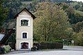
Bell shrine at the vlg. Jostl


Today's area of the village has been divided along the road since the creation of the local communities after 1848/49 , between Schäffern and Sparbaregg (1964 Sparberegg). The houses there formed the village of Elsenau Sparberegg (village code 15202). In 1968 the municipality of Sparberegg came to Schäffern, so the whole place was in one municipality. In the following year, however, the village / cadastral community Sparberegg came to Pinggau. The village of Elsenau Sparberegg was dissolved in 2012 and divided into Elsenau, the location of the name Elsenau-Sparberegg is now located in the Pinggau municipality. In the same year the scattered houses in Karnegg also became a separate village.
| Hzgt. Steier | Bld. Styria | |||||||||||||||||||
| ( Kthm. Austria ) | ( Austria - Ugrn. ) | ( Rep. Austria ) | ||||||||||||||||||
| 1521 | 1527 | 1542 | 1572 | 1685 | 1770 | 1782 | 1810 | 1812 | 1846 | 1869 | 1951 | 1961 | 1971 | 1981 | 1991 | 2001 | 2011 | 2017 | ||
|---|---|---|---|---|---|---|---|---|---|---|---|---|---|---|---|---|---|---|---|---|
| Elsenau (locality) | - | 407 | 345 | 230 | 294 | 403 | 341 | 317 | 315 | 344 | 396 | 427 | 374 | 361 | // | 304 | ||||
| * 23 | 19th | ∗ 20 | 21st | - | ∗∗ 78 | - | 74 | 70 | - | 60 | 49 | 54 | 57 | 81 | 88 | 91 | // | 94 | ||
| Elsenau (OB) | - | 170 | 193 | - | ||||||||||||||||
| ∗ 11 | 7th | ∗ 8 | 8th | 10 | - | 26th | 34 | - | ||||||||||||
| Elsenau-Sparberegg | - | - | 42 | // | - | |||||||||||||||
| - | - | // | - | |||||||||||||||||
// ... jump in the series 2011 to 2017: village with Elsenau-Sparberegg (2006: 14 houses), but without Karnegg (2017: 80 inhabitants, 33 addresses)
OB ... locality component (the actual village)
literature
- Annemarie Winkler: Elsenau. Heimatbuch, 3rd edition, self-published, Elsenau 2011.
proof
- 62247 - Shepherds. Community data, Statistics Austria .
-
↑ a b Kurt Klein (edit.): Historical local dictionary . Statistical documentation on population and settlement history. Ed .: Vienna Institute of Demography [VID] d. Austrian Academy of Sciences . Styria Part 1, Schäffern: Götzendorf , p.
133 ( online document , explanations . Suppl . ; both PDF - oD [updated]). Special sources: 1521 oA • 1527: body tax deposits, StLA. • 1542: Validity estimates, StLA. • 1572: Smoking money deposits 1572/73 , StLA. • 1685 onA • 1770: military conscription. Inhabitants according to Manfred Straka: Administrative boundaries and population development in Styria 1770-1850: Explanations for the first delivery of the Historical Atlas of Styria . In: Research on the historical regional studies of Styria 31, 1978. Houses according to the Austrian State Archives, War Archives, bundle 1771-98-44 . • 1782: Parish census, Graz diocesan archive. Quoted in Manfred Straka: The parish count of the year 1782 in Styria In: Contributions to researching Styrian historical sources 48, 1961. • 1810: Military conscription. According to Joseph Marx Liechtenstern: Statistical-topographical regional schematic of the Duchy of Styria. 1818. Arr. Straka, as 1770. • 1812: Military conscription: Carl Schmutz: Historisch-topographisches Lexicon von Steyermark. 4 vols. 1822/23. Ed. Straka, as in 1770. • 1846: Military conscription. Announcement about the judicial organization of the Crown Land of Styria , 1849. According to Adolph Schaubach: Salzburg, Upper Styria, the Austrian mountains and the Salzkammergut. 3rd volume of The German Alps , 1865; 2nd edition. The south-eastern Tyrol and Styria, Lungau, Carinthia, Krain, Görz and the coastal region . 5th vol. The German Alps , 1867. Quoted from Straka, as in 1770 and 1782. • 1869: Statistical Central Commission (ed.): Local repertories of the kingdoms and countries represented in the Austrian Imperial Council . 1871. • 1951 and later: Austrian Central Statistical Office / Statistics Austria (ed.): Directory of places . Results of censuses; from 2011 register censuses: 2011: Shepherds: population by locality. Register census October 31, 2011. (accessed October 27, 2017); 2017: Austria: residents by location. Updated content (Excel file, last accessed on 1.1.2017, on October 31, 2017; address as of October 31, 2017, SAGIS online → search: address).
- ↑ a b c Parish Schäffern. stift-vorau.at, accessed October 28, 2017.
- ↑ a b Brief history in Heinrich Purkarthofer: The Styrian municipal coats of arms awarded in 1991 and 1992. In: Mitteilungen des Stmk. Landesarchivs 42–43 (1992/1993), appendix, p. 57 ( full article p. 45–64 , landesarchiv.steiermark.at; there p. 13).
- ^ A b Andrea Zingl, Herbert Heissenberger: Elsenau - a district around the Schäffernerbach. In: Zeleid von Schäffern , No. 11, 2006, pp. 12–13 ( pdf , zeleid.heimat.eu).
- ↑ Dean's office. stift-vorau.at, accessed October 28, 2017.
- ^ History of our parish. schaeffern.at, accessed November 6, 2017.
- ↑ Friedenskapelle with Fam. Gamperl. Photo, zeleid.heimat.eu, accessed November 6, 2017.

Cadastral municipalities: Anger | Elsenau | Götzendorf | Knolln | Shepherds
Localities: Anger | Elsenau | Götzendorf | Guggendorf | Haberl | Karnegg | Knolln | Neussing | Shepherds | hospital
Villages: Götzendorf | Shepherds | Spital • Rotte: Elsenau • Scattered houses: Anger | Haberl | Hartberg | Karnegg | Knolln | Neussing • Other locations: Bärnegg ruins | Elsenau-Sparberegg
Counting district: Shepherds | Sparberegg
Former municipality: Sparbaregg (Sparberegg) 1850–1968