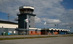
Kramfors-Solleftea Airport
| Kramfors-Solleftea Airport | |
|---|---|

|
|
| Characteristics | |
| ICAO code | ESNK |
| IATA code | KRF |
| Coordinates | |
| Height above MSL | 10 m (33 ft ) |
| Transport links | |
| Distance from the city center | 19 km north of Kramfors , 28 km southeast of Sollefteå |
| Street | 90 |
| train | Kramfors-Sollefteå Flygplyts station |
| Local transport | taxi |
| Basic data | |
| opening | 1974 |
| operator | Kramfors Municipality and Sollefteå Municipality |
| Terminals | 1 |
| Passengers | 8,735 (2016) |
| Air freight | 10 t (2016) |
| Flight movements |
1,978 (2016) |
| Start-and runway | |
| 17/35 | 2001 m × 45 m asphalt |
The Kramfors-Sollefteå Airport (alternatively High Coast Airport , IATA code : KRF , ICAO code : ESNK ) is an airport located in the province Västernorrland County in northern Sweden . It is located around 19 kilometers north of Kramfors and 28 kilometers southeast of Sollefteå . The airport is operated by the municipalities of Kramfors and Sollefteå . The airport has a 2001 meter long runway with the orientation 17/35 and was used by around 9,000 passengers in 2016.
Destinations
The airline Nextjet , which had regularly offered flights, ceased operations on May 16, 2018 due to the company's insolvency.
See also
Web links
- Kramfors-Sollefteå Airport website
- Aeronautical map for Kramfors-Sollefteå on SkyVector.com
Individual evidence
- ↑ a b c AIP SWEDEN ES-AD-2-ESNK. (PDF; 105 KB) In: lfv.se. LFV , February 2, 2017, accessed May 10, 2017 (Swedish, English).
- ↑ Passenger frequency at Swedish airports. (Excel; 277 KB) In: transportstyrelsen.se. Transportstyrelsen (Transport Authority), February 20, 2017, accessed May 10, 2017 (Swedish).
- ↑ Freight frequency at Swedish airports. (Excel; 263 KB) In: transportstyrelsen.se. Transportstyrelsen (Transport Authority), January 24, 2017, accessed May 10, 2017 (Swedish).
- ↑ Landing frequency of the Swedish airports. (Excel; 258 KB) In: transportstyrelsen.se. Transportstyrelsen (Transport Authority), February 20, 2017, accessed May 10, 2017 (Swedish).