Fuscher Kar head
| Fuscher Kar head | ||
|---|---|---|
|
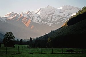
The Fuscher-Kar-Kopf (far right) from Ferleiten in the Fuscher Valley. |
||
| height | 3331 m above sea level A. | |
| location | Carinthia and Salzburg , Austria | |
| Mountains | Glockner group | |
| Dominance | 3.53 km → High Dock | |
| Notch height | 490 m ↓ Fuscher-Kar-Scharte | |
| Coordinates | 47 ° 5 '59 " N , 12 ° 44' 41" E | |
|
|
||
| rock | Limestone slate, violas | |
| First ascent | in the 1840s by Gregor Maier | |
The Fuscher-Kar-Kopf (formerly also called Fuschereiskarkopf ) is a mountain consisting of two peaks on the main Alpine ridge in the Glockner group of the Hohe Tauern . It lies on the border between the Austrian federal states of Salzburg and Carinthia . The main peak is 3331 m above sea level. A. hoch, the north-west summit has a height of 3252 m . The two peaks are about 500 meters apart and connected by a curved firn-covered ridge.
To the northwest and west run further pronounced ridges that form the main Alpine ridge. The Heiligenbluter Freiwand branches off to the southeast , a mighty side ridge that begins as a southeast ridge at the Fuscher-Kar-Kopf. The north-west summit has a huge west wall about 650 meters high , which was previously covered with firn, but is now covered with loose rock slabs. The mountain can be easily reached from the Hofmannshütte via the southwest ridge and offers a good view of the Großglockner and the Pasterze . The Fuscher-Kar-Kopf was first climbed in the 1840s by the hunter Gregor Maier, known as Badhans , from Fusch .
Surroundings
The Fuscher-Kar-Kopf is surrounded by glaciers , except in the southeast . In the west is the waterfall angle , the southern, lower part of the Bockkarkee , in the north the small Fuscherkarkees and in the west the insignificant Freiwandkees . Finally, the Pasterze , the largest glacier in the Eastern Alps, extends to the south . Neighboring mountains in the north-west ridge , separated by the Fuscher-Kar-Scharte located at an altitude of 2841 m , are the 3154 m high Breitkopf and then the Middle Bärenkopf at 3358 m . In the course of the west ridge , which forms the main Alpine ridge, lies the 3261 m high Sinwelleck , separated by a notch called Der Rinner ( 3145 m ) . The Kapuziner ( 2852 m ) and the 3027 m high Spielmann follow further east . To the southeast, along the Heiligenbluter Freiwand rise, separated by the Freiwandscharte ( 2975 m ), Freiwandspitz ( 3034 m ) and Freiwandkopf ( 2854 m ). To the south of the two peaks is the Gamsgrube , a massive, cauldron-shaped Hochkar with a diameter of 600 meters . The nearest significant settlement is Heiligenblut in Carinthia, about 8 kilometers to the south-east as the crow flies . Fusch in Salzburg lies a good 15 kilometers to the north-east on the Großglocknerstrasse .
Bases and tours
Today's normal route , the easiest ascent to the Fuscher-Kar-Kopf, was first climbed on August 27, 1882 by geologists Carl Diener , August Böhm von Böhmersheim , Friedrich Teller and Carl von Camerlander. Their route led from the Hofmannshütte at 2,444 m above sea level over the south-west ridge (Gamsgrubengrat) first to the north-west summit and then over the connecting ridge in a westerly direction to the Fuscher-Kar-Kopf main summit. Today this path is partially equipped with wire rope insurance, and the summit bears a cross . According to the literature, the walking time from the hut is about 2½ hours and the difficulty of the path is UIAA I + . Further climbs lead over the other ridges and as an ice tour since 1920 through the north face and north flank (up to 450 meters in altitude and an ice slope of 50 °). The west face, which Hubert Peterka and companions first climbed in 1927, has no longer been accessible since the ice cover melted due to global warming because of the great danger of falling rocks.
Literature and map
- Willi End : Alpine Club Guide Glockner Group , Bergverlag Rother , Munich 2003, ISBN 3-7633-1266-8
- Eduard Richter (editor): The development of the Eastern Alps , III. Volume published by the German and Austrian Alpine Club, Berlin 1894
- Alpine Club map 1: 25,000, sheet 40, Glockner group
Web links
Individual evidence
- ↑ Clem Clements, Jonathan de Ferranti, Eberhard Jurgalski , Mark Trengove: The 3000 m SUMMITS of AUSTRIA - 242 peaks with at least 150 m of prominence , October 2011, p. 17.
- ↑ Federal Office for Metrology and Surveying Austria: Fuscher-Kar-Kopf on the Austrian Map online (Austrian map 1: 50,000) .
- ↑ Eduard Richter: The development of the Eastern Alps , III. Volume, Berlin 1894, p. 219 and 637
- ^ Oesterreichische Alpenzeitung , Vienna 1883, p. 351
- ↑ Willi End: Alpenvereinsführer Glocknergruppe , Munich 2003, p. 386 ff., Margin no. 1410 ff.


