Igaliku
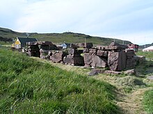
| Igaliku (abandoned cooking area) | ||
|---|---|---|
| Garðar (courtyards) Igaliko |
||
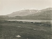
| View of Igaliku (2008) | ||
| Commune | Kujalleq municipality | |
| District | Narsaq | |
| Geographical location | 60 ° 59 '27 " N , 45 ° 25' 9" W | |
|
|
||
| Residents | 21 (January 1, 2020) |
|
| founding | 1782 | |
| Time zone | UTC − 3 | |
| particularities | northern ruins | |
Igaliku [ iˈɣaliku ] (according to the old spelling Igaliko ; in the Viking Age : Garðar ) is a Greenlandic settlement in the district of Narsaq in the municipality of Kujalleq .
location
Igaliku is located at the end of the Igalikup Kangerlua fjord at the point where the peninsula protrudes, at the end of which is Qaqortoq , the main town of Kujalleq municipality. The shepherd settlements of Iterlak and Igaliku Kujalleq are located on a branch of the fjord about 11 km to the south . The next larger towns are Qassiarsuk and Narsarsuaq 19 km north on Tunulliarfik .
history
At the site of Igaliku was the place Garðar in the Middle Ages, where the Grænlendingar with the cathedral of Garðar had their bishopric . The cathedral church was unusually large and well developed for what was then Greenland: It was 27 meters long and up to 16 meters wide and probably even had glass windows. Little remains of it, however; the best preserved ruins are those of the bishop's house and its stable.
Igaliku was founded in 1782 by Anders Olsen . His farm in Upernaviarsuk had previously burned down. Anders Olsen died in 1786 and the farm was taken over by his son Johannes Andersen . He was the father of Povl Egede (* 1799), who took the surname Egede. In 1850, 19 people lived in Igaliku, who made their living mainly from fishing and seal hunting, while still keeping cows and sheep on the side. His successor as "King of Igaliku" was his son Søren Egede (* 1833).
From 1911 Igaliku was part of the Narsaq community as a residential area.
In 1919 there were 67 residents. There was a 27 m² school chapel in Igaliku. In addition to twelve residential buildings, there were six cow stalls, two sheep stables and nine hay stores. Among the residents were eleven hunters and a fisherman, a midwife and a catechist. Because the residents could not make a living from raising cattle at that time, they also hunted, although it is said that they were very bad kayakers. Still, they caught seals, foxes and polar bears.
In 1928 a church was built. In 1933 Igaliku was promoted to Udsted and an apartment for the Udsteds administrator, a shop and warehouse, a powder house and a coal house were built. Later the place was also given a fish house, which was hardly used, however, since fishing did not play a decisive role in Igaliku. In 1934 Grønlands Landsråd demanded that Igaliku should become its own municipality. The background was that the sheep farmers could manage the area around their place themselves and this would not have been managed from Narsaq . In 1937 Igaliku was finally made an independent community. The attempt from 1945 to expand the municipal area because of good grazing areas was rejected in 1946. Between 1918 and 1950, 67 to 146 people lived in Igaliku. From 1950 Igaliku belonged to the new municipality of Narsaq . In 1960 there were only 117 people left in Igaliku and in 1970 83 people.
On August 6, 2004, the then US Secretary of State Colin Powell visited the site and signed a contract with the Foreign Ministers of Greenland and Denmark, Josef Motzfeldt and Per Stig Møller , to expand Thule Air Base as part of the National Missile Defense .
Since the administrative reform in 2009, Igaliku has belonged to the Kujalleq municipality .
Igaliku has been part of the Kujataa UNESCO World Heritage Site since 2017 .
economy
Igaliku lives mainly from sheep farming . A total of 2100 sheep are kept on five farms, 30 tons of Igaliku sheep are slaughtered in Narsaq every year . Due to its size, the place belongs to the South Greenlandic shepherd settlements with village status. Due to the medieval ruins and the existing hiking trails, Igaliku is a popular tourist destination, which is the second economic mainstay of the place.
Infrastructure and supply
Since 2016, the energy supply company Nukissiorfiit has been trying to supply the town with electricity using solar and wind energy. A waterworks supplies Igaliku with drinking water. Garbage is dumped in the north of the village.
The roads in Igaliku are gravel. The port has a six meter long pier built in 1976 and a pontoon jetty .
Development
The school in Igaliku was attended by three students in 2016. The village also has a meeting building, a church and a football field.
It is noticeable that the buildings in Igaliku are the only ones in Greenland that are made of red sandstone and that they also have other structural peculiarities (see List of Monuments in Greenland # 20th Century ).
Sons and daughters
- Jakob II Egede (1901–1988), poet, composer and musician
- Egede Motzfeldt (1907–?), Provincial Councilor
- Josef Motzfeldt (* 1941), politician (Inuit Ataqatigiit) and teacher
Population development
The population of Igaliku was around 150 in the middle of the 20th century, but has fallen sharply since then. Since about 2006 the population has remained almost constant at around 20 to 30 residents.

Web links
Individual evidence
- ↑ Map with all official place names confirmed by Oqaasileriffik , provided by Asiaq
- ↑ Heinz Barüske: Greenland: culture and landscape of the Arctic Circle . DuMont, Cologne 1990, ISBN 3-7701-1544-9 .
- ↑ Louis Bobe : Beskrivelse af Distrikterne i Sydgrønland: Julianehaab district. History . In: Georg Carl Amdrup , Louis Bobé , Adolf Severin Jensen , Hans Peder Steensby (eds.): Grønland i tohundredeaaret for Hans Egedes landing (= Meddelelser om Grønland . Volume 60-61 ). tape 2 . C. A. Reitzel Boghandel, Copenhagen 1921, p. 556 ( digitized version in the Internet Archive ).
- ^ Ole Bendixen : Beskrivelse af Distrikterne i Sydgrønland: Julianehaab district. Bopladser i Julianehaab district. Bopladsen Igaliko . In: Georg Carl Amdrup , Louis Bobé , Adolf Severin Jensen , Hans Peder Steensby (eds.): Grønland i tohundredeaaret for Hans Egedes landing (= Meddelelser om Grønland . Volume 60-61 ). tape 2 . C. A. Reitzel Boghandel, Copenhagen 1921, p. 503 f . ( Digitized in the Internet Archive ).
- ↑ Jens Christian Madsen: Udsteder og bopladser i Grønland 1901-2000 . Atuagkat, 2009, ISBN 978-87-90133-76-4 , pp. 41 f .
- ^ History made in Southern Greenland ( Memento of April 28, 2008 in the Internet Archive )
- ↑ Nomination to UNESCO's World Heritage List - Kujataa - a subarctic farming landscape in Greenland (nomination of the Kujataa region for UNESCO World Heritage) (.pdf)
- ↑ a b c Igaliku at kujalleq2017.odeum.com
- ↑ Population of Igaliku 1977–2020 at bank.stat.gl


