Geography of Bolivia
The geography of Bolivia is unique among the countries of South America . Besides Paraguay, Bolivia is the only landlocked country on the continent and some of the highest peaks are also located here. The main features of Bolivian geography are the Altiplano , a plateau of the Andes, and Lake Titicaca (Lago Titicaca) , the largest lake in South America and the highest commercially navigable lake in the world.
location
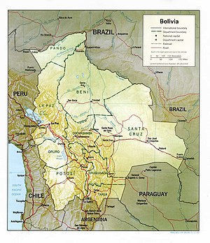
Bolivia covers an area of 1,098,580 km², of which 14,190 km² is water. This is roughly twice the size of Spain . The country is located in the west of South America and borders five countries over a length of 6,743 km:
| Neighboring country | Limit length | orientation |
|---|---|---|
| Brazil | 3,400 km | Northeast |
| Peru | 900 km | northwest |
| Chile | 861 km | southwest |
| Argentina | 832 km | south |
| Paraguay | 750 km | Southeast |
Geographic regions
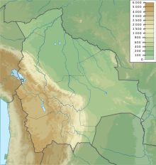
The Andes draw a wide arc through the west of Bolivia and thus determine the three geographical zones of the country: The mountains and the Altiplano in the west, the subtropical Yungas and temperate valleys of the eastern foothills of the mountains, and the tropical lowlands (llanos) in the east of the Landes (Oriente) . The Andes run in two large, parallel mountain ranges ( cordilleras ) . The western ( Cordillera Occidental ) runs along the borders with Peru and Chile. The eastern ( Cordillera Oriental ) mountain range is very wide and runs from Peru to Argentina. Between these two lines lies the Altiplano, a wide plateau 805 km long and 129 km wide.
climate
Although Bolivia is completely in the tropical latitude, the climatic conditions vary a lot; from the tropical climate in the lowlands to the polar climate in the highest regions of the Andes. The temperatures depend largely on the altitude and change little seasonally. In most of the country, rainfall is greatest during the summer of the southern hemisphere. The total amount of precipitation decreases from north to south.
The northern lowlands have a humid tropical climate with year-round high temperatures, high humidity and heavy precipitation. The daily highs in most places in this region are above 30 ° C on a year-round average. The northeast trade wind that blows over the Amazon basin brings high amounts of precipitation with it. The rain often falls in short thunderstorms and is sometimes accompanied by strong gusts and hail.

The central lowlands have both a humid tropical and a dry climate. From October to April, the north-east trade wind ensures hot, humid and rainy weather. From May to September, the southwest trade wind dominates and ensures only minimal rainfall. During this dry season, sunny days and clear nights make for more extreme daily highs and lows. Occasional strong southerly winds (surazos) can occur in winter , which provide cold for a few days.
The Chaco has either a tropical or a dry climate. The northeast trade wind provides rain and hot and humid conditions from January to March. The remaining months are dry with hot days and cold nights. The highest temperature ever recorded in Bolivia, 47 ° C, was measured here. The Surazos also reach the Chaco; their arrival is usually indicated by a strong storm front.
The temperatures and amounts of precipitation in the mountains vary considerably. The Yungas, where the humid northeast trade winds are displaced by the mountains, is the cloudiest, wettest and rainiest area with up to 1,520 mm of precipitation annually. In the protected valleys and basins in the Cordillera Oriental there are mild temperatures and moderate amounts of precipitation (between 640 and 760 mm annually). Temperatures decrease with increasing altitude. Snowfall is possible at altitudes above 2,000 m and there is permanent snow above 4,600 m. In areas above 5,500 m there is a polar climate with partial glaciation . The Cordillera Occidental is a high-altitude desert with cold, wind-shaped peaks.

The Altiplano, which is also influenced by strong, cold winds, has a dry and cool climate with large daytime temperature fluctuations and decreasing rainfall from north to south. The mean daily maximum temperatures are between 15 and 20 ° C, and the tropical summer sun can sometimes reach up to 27 ° C. After sunset, the air stores little heat and cools quickly to just above freezing point. Lake Titicaca has a moderate influence on the climate, but even on its shores there are almost monthly frosty nights and snowfall is not uncommon.
Lake Titicaca
The most famous feature of the Altiplano is the large lake at the north end, Lake Titicaca. At an altitude of 3,810 m, it is the highest commercially navigable waterway on earth. With an area of 9,064 km², it is about half the size of Saxony and thus the largest lake in South America. The lake is also up to 281 m deep and with an average depth of 215 m the amount of water is large enough to maintain a constant temperature of 10 ° C. The lake has a moderate climate for a considerable radius, which enables the cultivation of wheat and maize in protected areas.
The water of Lake Titicaca flows slowly in a southerly direction through the Río Desaguadero , a river covered with reeds , into Lake Poopó . In contrast to the freshwater lake Titicaca, Lake Poopó is salty and shallow; the depth rarely exceeds four meters. Due to the complete dependence on seasonal precipitation and the water level of Lake Titicaca, the size of the Poopósee varies considerably. Due to low rainfall or the silting of the Desaguaredo River, Lake Poopó was almost completely dried out several times in the 20th century. In years with heavy rainfall, on the other hand, Lake Poopó flooded the Coipasa salt basin to the west .
The mountains
The Cordillera Occidental is a chain of extinct volcanoes with occurrences of mud volcanoes and volcanic springs from which sulphurous gases escape. The snow-covered Sajama , the highest point in Bolivia at 6,542 m, is, like the other high peaks, of volcanic origin. Apart from the volcanic cones, the mountain range is only moderately reliefed and has an approximate height of 4,000 m in the north and a little less in the south. Rainfall is low, especially towards the south. Occasionally, mostly in damp locations, shrub vegetation can be found. In the extremely arid southern part, the landscape shows only very sparse, cold and salt-tolerant vegetation types. The entire Cordillera Occidental is sparsely populated, the south is largely uninhabited.
The Altiplano, the plateau between the two Cordilleras, comprises four main basins. These are limited by mountain ranges that run from the Cordillera Occidental in an easterly direction to about half the way to the Cordillera Oriental. The eastern part of the Altiplano is quite flat and has been an important north-south corridor for transports, not just since the colonial era an internal drainage that ends in large salt plains in the south.
The amount of precipitation in the Altiplano decreases in a southerly direction, the shrub vegetation is also becoming more sparse, sometimes there is only bare stone and dry, red clay. Several salt flats exist in the region as the remains of earlier ice age lakes. The largest of these is the Uyuni Salt Pan ( Salar de Uyuni ), which covers over 9,000 km². The salt crust in this level is up to five meters thick in the center. Heavy trucks can cross the lake floor in the dry season. The main basin of the Altiplano ends near the Argentine border.
The much older Cordillera Oriental reaches Bolivia on the north shore of Lake Titicaca and continues in a south-easterly direction to about 17 ° south latitude, only to get wider in the further, southern course to the Argentine border. The northernmost part of the Cordillera Oriental, the Cordillera Real , is an impressive, snow-covered granite mountain range. Many of the peaks are over 6,000 m and have extensive glaciations. The best known also mark the end points of the chain - in the northwest of Illampú (6,368 m) and, overlooking the basin of La Paz , Illimani , Bolivia's second highest mountain at 6,439 m.
The character changes south of the 17th parallel. Here the mountains are referred to as Cordillera Central ; Active tectonic fractures divide the landscape into plateaus of different heights, evident through high steep slopes. The Cordillera here consists of high, slightly undulating surfaces between 4,200 and 4,400 m altitude with some peaks of volcanic origin. At this altitude, the puna , the vegetation resembles a dry steppe. Only modest arable and pasture farming is possible here (subsistence farming).
The valleys
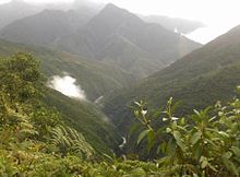
The north-eastern flank of the Cordillera Real is known as the Yungas (from the Aymar word for "warm valleys"). The steep, almost inaccessible walls and peaks of this largely semi-tropical area northeast of La Paz offer something of the most spectacular landscape in Bolivia. There is heavy rains, and rich vegetation climbs the sides of narrow river valleys. This region is the most fertile in Bolivia, but due to difficult transport conditions, agricultural development is hindered. Coroico is an important and touristic city in the region . In 1917 the government tried to build a railway line through the Yungas to connect La Paz with the eastern lowlands. The construction of the line was canceled and abandoned after 150 km of completion.
The eastern foothills of the Cordillera Central become lower and lower in mountain ranges and ranges of hills in north-south direction, until they finally form the easternmost barrier in front of the Bolivian lowlands in the foothills . Rivers flowing in an easterly direction have cut long, narrow valleys into the landscape. These valleys and the plains between the mountain ranges offer excellent conditions for agriculture and livestock. Fertile alluvial soils have filled the low areas. In some areas erosion has occurred in the course of clear cutting . The valleys are often between 2,000 and 3,000 m altitude, and this lower altitude has significantly milder temperatures than the Altiplano. Two of the most important cities in Bolivia, Sucre and Cochabamba , are on such plains of the Eastern Cordillera Central.
Lowlands
The eastern lowlands cover the entire area of Bolivia north and east of the Andes. Although they take up two thirds of the country's area, the region outside the metropolis of Santa Cruz is still sparsely populated, but it is playing a growing role economically.
Topographical and climatic differences divide the lowlands into three areas.
- The flat northern area, consisting of the Beni Department , the Pando Department and the northern part of the Cochabamba Department consists of tropical rainforest . Since the topsoil is on a clay subsoil, hardly any water can be stored and heavy rains regularly turn the area into a swamp.
- The central area, consisting of the northern half of Santa Cruz Department , has rolling, rounded hills and a drier climate than the north. Forests alternate with savannah and most of the land has been cleared for agriculture. Santa Cruz , the largest city in the lowlands, is located here, as is most of Bolivia's oil and gas reserves.
- The south-eastern part of the lowlands is the continuation of the Chaco Paraguay. For nine months of a year this area is largely dry and due to heavy rainfall it becomes a swamp for the remaining three months. These extreme changes in rainfall allow only bush and shrub vegetation and animal husbandry. Recently, oil and natural gas were also found here in the foothills of the Andes and have attracted some settlers.
Most of the most important Bolivian rivers can be found in the water-rich northern part of the lowlands, for example in the Alto Beni, where the land allows for the cultivation of coffee and cocoa . The northern lowlands are traversed by slow-flowing, wide rivers, the three largest - Mamoré, Beni and Madre de Dios - all flow north into Madeira and from there into the Amazon . River boats along the Beni and Mamoré rivers carry both passengers and cargo. Rapids in the further course of Madeira, however, prevent further transport into Brazil. In the vicinity of the Paraguayan border, sandy streams carry the seasonal rain into the Río Pilcomayo or Río Paraguay .
facts and figures
- Geographical location: 9 ° 40 '- 22 ° 50' S, 57 ° 40 '- 69 ° 35' W (rough values)
- Climate: Varies with altitude; from humid tropical to cold and dry
- Topography: mountain ranges of the Andes with a high plateau ( Altiplano ), hilly landscapes and the lowlands of the Amazon basin
- Lowest point: Río Paraguay , 90 m
- Highest point: Nevado Sajama , 6,542 m
- Natural resources: tin , natural gas , petroleum , zinc , tungsten , antimony , silver , iron , lead , gold , wood and hydropower
- Land use:
- arable land: 2%
- Sustainable agriculture: 0%
- Permanent pastures: 24%
- Forests: 53%
- Other: 21%
- Irrigated land: 1,750 km²
literature
- Ismael Montes de Oca: Enciclopedia Geográfica de Bolivia. Atenea, La Paz 2005, ISBN 99905-0-567-5 (Spanish).
- Rex A. Hudson, Dennis M. Hanratty (Eds.): Bolivia. A Country Study. Washington: GPO for the Library of Congress, 1989 (English).


