Gickel
| Gickel | ||
|---|---|---|
|
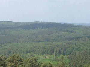
View from the observation tower on the local mountain to the Gickel |
||
| height | 505.1 m above sea level NHN | |
| location | at Bodenrod ; Wetteraukreis , Hessen ( Germany ) | |
| Mountains | Taunus | |
| Dominance | 0.4 km → Hesselberg | |
| Coordinates | 50 ° 24 '9 " N , 8 ° 34' 1" E | |
|
|
||

The Gickel near Bodenrod in the Hessian Wetteraukreis is 505.1 m above sea level. NHN high mountain near the Hesselberg (approx. 518 m ) in the Taunus .
geography
location
The Gickel is located in the northeast of the Eastern Hintertaunus in the Taunus Nature Park . Located in the Butzbach Forest , its summit rises almost 400 m north of that of the Hesselberg and about 900 m east-northeast of the village church of the Butzbach district of Bodenrod . To the north-northwest, the forest landscape slopes down to Weiperfelden (to Waldsolms ) in the neighboring Lahn-Dill district , about 2 km away (as the crow flies ) .
Neighboring mountains
In addition to the already mentioned Hesselberg (approx. 518 m ) , the north- eastern foothills of the Gickel include its northeastern Hainbuchenkopf ( 492.3 m ), the north-northeast of it, which can be reached via a notch , the Hinterste Kopf ( 491.1 m ), and the 2.4 km east lying Brüler mountain ( 424.2 m ), the 1.7 km south-west location Thunderhead ( 485.2 m ), the 2km west located Eselsberg ( 439.2 m ) and 2.1 kilometers (depending on distance) northwest lying Hardenberg ( 439.4 m ).
Watershed and rivers
The Gickel lies on the watershed between the Lahn and Main , two tributaries of the Rhine . To the north, the upper reaches of the Lahn tributary Solmsbach , which rises in Espa and is fed by the Eichelbach, which flows northwards to the west of the Bodenrod elevation , runs roughly in an east-west direction near the source. The upper reaches of the Fauerbach , whose water reaches the Main through the Usa and Wetter, runs east near the source .
Natural allocation
The Gickel belongs in the natural area main unit group Taunus (number 30), in the main unit Eastern Hintertaunus (302) to the natural area Bodenroder Kuppen (302.2).
Transport links
The state road 3053 runs north past the Gickel along the Solmsbach between Espa and Weiperfelden , to the west the L 3270 runs between Bodenrod and Weiperfelden and in the south-west the L 3353, which leads from there to Münster , meets the L 3270 at Bodenrod European long-distance hiking trail E3 .

