Hesselberg (Butzbach)
| Hesselberg | ||
|---|---|---|
|
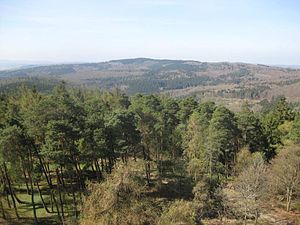
View from the Hausberg tower southwest to the Hesselberg |
||
| height | 518 m above sea level NHN | |
| location | at Bodenrod ; Wetteraukreis , Hessen ( Germany ) | |
| Mountains | Taunus | |
| Dominance | 10.4 km → Steinkopf | |
| Notch height | 129 m ↓ Merzhausen , Usingen earth station |
|
| Coordinates | 50 ° 23 '56 " N , 8 ° 34' 0" E | |
|
|
||
| particularities | Location of a transmission tower | |

The Hesselberg im Taunus near Bodenrod in the Hessian Wetteraukreis is about 518 m above sea level. NHN the highest mountain in the northeast of the Eastern Hintertaunus .
geography
location
The wooded Hesselberg is located in the northeast of the Eastern Hintertaunus in the Taunus Nature Park . Located in the Butzbach Forest , its peak rises 850 m ( air line ) east-southeast of the village church of the Butzbach district of Bodenrod . A transmission tower is located a little southwest of the summit .
Natural allocation
The Hesselberg belongs in the natural spatial main unit group Taunus (No. 30) and in the main unit Eastern Hintertaunus (302) to the sub-unit ground harvesters knolls (302.2). The landscape leads north into the sub-unit Wetzlarer Hintertaunus (302.0), to the south-west it falls into the sub-unit Usinger Becken (302.5) and to the south-east into the sub-unit Münster-Maibach-Schwelle (302.4).
Neighboring mountains
With neighboring elevations of Hesselberg include its northern neighbor Gickel ( 505.1 m ), the Northeast foothills hornbeam head ( 492.3 m ), the north-northeast of which more than a notch to reach Hinterste head ( 491.1 m ENE), 2.5 km lying Brüler mountain ( 424.2 m ) and 1.5 km (depending crow flies) west-southwest location Thunderhead ( 485.2 m ).
Watershed and rivers
The Hesselberg lies on the watershed between the Lahn and Main , two tributaries of the Rhine . The upper reaches of the Lahn tributary Solmsbach , which rises in Espa and is fed by the Eichelbach, which flows northwards from the elevation of Bodenrod , runs north past the Gickel , roughly in an east-west direction near the source. The upper course of the Fauerbach runs to the east near the source , and the Forbach tributary Krebsbach rises to the southeast ; Ultimately, their water reaches the Main through the USA and weather .
Transport links
The state road 3053 runs north past the Hesselberg, beyond the Gickel , along the Solmsbach between Espa and Weiperfelden , the L 3270 runs to the west between Weiperfelden, Bodenrod and Michelbach , and the L 3353 runs south-west from Bodenrod to Münster European long-distance hiking trail E3 .
See also
Individual evidence
- ↑ a b Map services of the Federal Agency for Nature Conservation ( information )
- ↑ TK 25. The numbers for dominances and celebrities in the Taunus according to Highrisepages.de are somewhat imprecise here. The notch at the earth station is below 390 m , but above 387.5 m . Since the Hesselberg is not measured to the nearest decimeter (not even the 518 m height is recorded on the TK 25), it cannot be decided whether the Steinkopf ( 518 m ) is actually higher. Otherwise the dominance would be around 14.5 km up to correspondingly high points on the horse's head and long neck .
- ↑ Brigitte Schwenzer: Geographical land survey: The natural space units on sheet 139 Frankfurt a. M. Federal Institute for Regional Studies, Bad Godesberg 1967. → Online map (PDF; 4.9 MB)

