
Border between Bosnia and Herzegovina and Montenegro
The border between Bosnia and Herzegovina and Montenegro separates the national territory from Bosnia and Herzegovina and Montenegro . It has a length of around 225 kilometers, on a straight line of about 140 kilometers.
Borderline
| Bosnia and Herzegovina Republika Srpska |
Montenegro |
|---|---|
| region | local community |
| Trebinje | Herceg Novi |
| Kotor | |
| Nikšić | |
| Plužine | |
| Foča | |
| Žabljak | |
| Pljevlja |
The common state border runs roughly northeast from the north of the Bay of Kotor over the high karst of the Dinaric Mountains to the northernmost Sandžak .
Croatia and Montenegro border each other on the Adriatic at Herceg Novi , the triangle is located about 8 kilometers from the coast on the Bjelotina near the Montenegrin town of Sitnica (around 950 m ). From there it runs over the Orjen and the Bijela gora - there the highest border peak is the Jastrebica ( 1862 m ) - into the valley of the Trebišnjica , where the Bilećko jezero reservoir near Bileća forms the border. Then it leads over the Volujak ( 2336 m ) to the Maglić massif ( 2386 m ), the highest mountain in Bosnia-Herzegovina, and down into the Piva gorge at Šćepan Polje (Montenegro) or Hum (Bosnia). Here on the Maglić lies the Bosnian-Herzegovinian Sutjeska National Park with the Perućica natural forest reserve , one of the most natural areas of the Western Balkans. It then runs up the Tara - the union of the Piva and Tara in Šćepan Polje is the beginning of the Drina - in its canyon a bit upwards, and crosses the Ljubišnja ( 2239 m ) into the valley of the upper Ćeotina . A little further east near the Serbian town of Kukurovići is the second triangle.
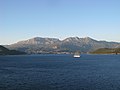
Orjen via Herceg Novi

At the Bilećko jezero
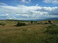
Borderland at Pljevlja


| Croatian-Bosnian-Herzegovinian border |
|
Bosnian-Herzegovinian-Montenegrin border |
|
Bosnian-Herzegovinian-Serbian border |
| Croatian-Montenegrin border | Montenegrin-Serbian border | |||
| Bjelotina | NN |
history


The border follows old municipal and Ottoman administrative boundaries , and was - with the exception of the Cattaro (Kotor) possession - also largely the southeastern border of Austria-Hungary after the occupation of Bosnia in 1878 with the principality, then the Kingdom of Montenegro . It was established in 1947 under Tito between the Socialist Republic of Bosnia and Herzegovina and the territory of Montenegro. It only became the international border after the collapse of Yugoslavia in 1991, initially between the new state of Bosnia and Herzegovina and the state of Serbia and Montenegro , and from 2006 after the collapse of this short-lived structure between the two present-day countries. According to the findings of the Badinter Commission, which was set up on the proposal of the then European Community and chaired by the French constitutional judge Robert Badinter, it was declared a state border as the previous partial republic border.
But a border dispute broke out. Bosnia-Herzegovina has no part of the Mediterranean because it is sealed off by the Dalmatian coast (Croatian Riviera) - except for the port city of Neum , which divides Croatia into two parts. Therefore, the Republika Srpska raised claims to the coastal Montenegrin town of Sutorina , which would have opened its own access to the Kotor Bay. This place had previously belonged to Herzegovina as a corridor, but then in 1947 the Bosnian Djuradj Pucar and the Montenegrin Blažo Janković negotiated the orographic mountain ranges as a border. Sutorina was transferred to Montenegro, while Bosnia and Herzegovina received Montenegrin territories east of the Sutjeska River in return . The dispute became so serious that Montenegro refused to send an ambassador to Sarajevo in the late 2000s .
The dispute could only be settled within the framework of the Western Balkans Conference and in May 2014 the border was contractually determined. As a result, problems arose again because the Socijaldemokratska partija raised objections in the Bosnian parliament . On August 24, 2015 - at the suggestion of the Austrian Federal President Fischer in Vienna - the President of Montenegro, Filip Vujanović , and the Chairman of the State Presidency of Bosnia-Herzegovina, Dragan Čović , signed a definitive border treaty between the two states.
- chronology
- (indented for modern times, times of war and sub-areas; in brackets: sub-areas)
- 15th century - 1878: Inner Ottoman border: Bosnia ( Bosnia and Herzegovina ) - Montenegro and Rumelia (until around 1800)
- 1878 (de facto, 1908 de jure) - 1918 (de jure): border Austria ( Dalmatia ) - Montenegro
- 1918–1992: inner Yugoslav border:
- 1918–1922: Bosnia and Herzegovina - Montenegro
- 1922–1929: Mostar - Zeta
- 1939–1941: no border ( Zeta )
- 1941–1945: Croatia (Dubrava and Vrhbosna) - Montenegro (Protectorate of Italy )
- 1945–1992: Bosnia and Herzegovina - Montenegro ; 1947 Change of territory to the current course
- 1992–2006 Bosnia and Herzegovina - Yugoslavia / Serbia-Montenegro (Montenegro)
- 2006 – present: border Bosnia and Herzegovina - Montenegro
Border crossing and border traffic

International border crossings between the two states are (the Bosnian side mentioned first):
-
Zupci - Sitnica on the Trebinje
 - Herceg Novi route
-
Klobuk - Ilino Brdo on the Trebinje
 - Nikšić route
-
Deleuša - Vraćenovići on the Bileća
 - Nikšić route 12
-
Hum - Šćepan Polje on the Foča
 - Nikšić route
-
Metaljka on the Goražde
 - Pljevlja route 3
Web links
Individual evidence
-
↑ In the end, the Sandžak remained Ottoman;
compare Changes in Turkey in Europe 1858 to 1878. From: JG Bartholomew: A literary & historical atlas of Europe , 1910 (image file on Commons);
the possession of Cattaro (Kotor) was given to Montenegro in 1806 when Dalmatia became French. - ↑ a b c d Bosnian claims to the Bay of Kotor. Report, Adelheid Wölfl, in: der Standard online, January 30, 2015.
- ↑ cf. Balkans: Yugoslavia Historical; Bosnia Serbia Montenegro; nationalities 1920 map. From: Harmsworth's new Atlas 1920 (image file on Commons).
- ^ A b c Western Balkans Conference - Border Agreement between Bosnia and Montenegro. In: Tiroler Tageszeitung online, 23 August 2015.
- ↑ Nedim Tuno, Admir Mulahusić, Mithad Kozličić, Zvonko Orešković: Border reconstruction of the Sutorina exit of Bosnia and Herzegovina to the Adriatic Sea by using old maps. onA (PDF, ddomusic.com, accessed April 25, 2013).
- ↑ cf. The Territories ahead… From: Appletons' annual cyclopædia and register of important events of the year… 1876, p. 750 (image file on Commons).
- ↑ a b Montenegro-Bosnia border treaty signed in Vienna. In: Salzburger Nachrichten online, August 26, 2015, accessed on September 1, 2015.
- ↑ a b Bosnia 1463, annexed Zeta 1499, Fstbst. Montenegro emerged in 1515; around 1800 Montenegro expanded to the east, 1852 Fst. , 1910 Kgr.
- ↑ Montenegro: border crossings. ÖAMTC (status: 04/2015, accessed March 11, 2015).


with:
Albania |
Bosnia and Herzegovina |
Kosovo |
Croatia |
Serbia![]()
![]()
![]()
![]()
![]()