Herbriggen
| Herbriggen | ||
|---|---|---|
| State : |
|
|
| Canton : |
|
|
| District : | Visp | |
| Municipal municipality : | St. Niklaus | |
| Postal code : | 3927 | |
| Coordinates : | 627 231 / 109340 | |
| Height : | 1260 m above sea level M. | |
| Website: | www.st-niklaus.ch | |
| map | ||
|
|
||
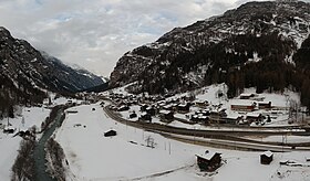
Herbriggen ( Valais German Herbriggu ), formerly also Herbrigen spelled, is a large cluster settlement in the municipality of St. Niklaus (Valais German Zaniglas ) in the Visp district and a parish of the Visp dean's office in the Swiss canton of Valais .
geography
Herbriggen is 5.5 kilometers south of St. Niklaus Dorf ( 1120 m above sea level , Valais German Zaniglas ) on the right bank of the Mattervispa at 1260 m above sea level. M. below the Nieschfäd ( 2400 m above sea level ). The village center of Herbriggens consists almost entirely of old buildings and a church , the northern part of economic buildings and the southern part of the Hotel Bergfreund and residential buildings.
The hamlet of Mattsand ( 1230 m above sea level ) is two kilometers north of Herbriggen , the hamlet Breitmatten ( 1280 m above sea level ) two kilometers south of Herbriggen . Between Herbriggen and Breitmatten there are the hamlets Längmatt ( 1261 m above sea level ) and Zenachern ( 1262 m above sea level ). In the hamlet of Zenachern you can admire a number of old houses that have been restored in an exemplary manner.
Mattsand, on a small pasture terrace, is on the right bank of the Vispa. The clustered settlement is bounded in the southwest by the compensation lake and the Vispa. 300 meters further north is the hamlet of Holzji ( 1237 m above sea level ). In the north and west is the Mattwald.
Compensation lake Mattsand
The water of the Vispa has been collected in the compensation lake in Mattsand since 1958 and via the 12.5 km long pressure tunnel that runs in the rock along the left flank of the Mattertal, the moated Törbel castle and the armored pressure shaft of the Ackersand headquarters, which is north of Stalden located at the end of the Vispertal . The Jungbach stream north of St. Niklaus Dorf has also been fed into this system via a sloping shaft since 2003.
Name customer
The access to the village used to be a bridge, hence the name Herbriggen ( towards the bridge ). The whole valley floor consists of sand up to two meters deep, hence the name of the hamlet Mattsand .
history
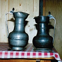
In 1635 there is a report about the construction of the Truffer house on the Biel near Herbriggen. The Herbriggen rifle guild was founded in 1848. There are two old tin cans. The year 1826 is engraved on one of the covers.
In 1865 the municipalities of inner Matt , to which today's village of Herbriggen and the hamlets of Mattsand and Breitmatten belonged, and outer Matt , which are separated by the Blattbach (left side of the Mattervispa ) and the Grosse Graben (right side of the Vispa), merged into the municipality Matt , which merged with the then parish of St. Niklaus in 1866 .
In 1870 Herbriggen received its own post, which was repealed in 1920. Since 1891 Herbriggen has been connected to the public transport network of the Brig-Visp-Zermatt Railway of the Matterhorn-Gotthard Railway by its own train station ( 1253.9 m above sea level ) . In 1967 the modern, wide road to Herbriggen was completed, replacing the old narrow mule track.
In 1904, Herbriggen and the hamlet of Breitenmatten counted 20 houses with 197 inhabitants, all of whom belonged to the Roman Catholic denomination .
Herbriggen has been its own parish with its own parish church since 1933 . The Herbriggen territory also has a total of two older chapels, namely Breitmatten and Mattsand . Due to a lack of priests, the mother parish of St. Niklaus also looks after the parish of Herbriggen ( parish association ).
Attractions
Personalities
- Adolf Imboden (1864–1935), politician , lawyer , notary and judge .
- Hieronymus Lochmatter (1916–1993), conductor and composer a . a. of the famous Walliser March.
Hiking trails and alpine tours
From Herbriggen a path leads up to the Galenberg to the Europaweg at 2581 m above sea level. M. being Following the Europaweg south Europahütte ( 2265 M. m above sea level. ) Reached. There, the Europaweg is crossed by the Domhüttenweg, which leads to the Domhütte ( 2940 m ).
The Bordierhütte ( 2886 m ) and the Täschhütte ( 2701 m ) in the south can also be reached via the Europaweg , as their hut paths also cross the Europaweg.
On the opposite side of the valley, the Weisshornweg and the Topalihütte ( 2674 m above sea level ) can be reached from Herbriggen via Mattsand, Schwiedernen and the Topaliweg , from Herbriggen going west at 1239 m above sea level. M. crosses the Vispa to Tumigen and then heads north, i.e. out of the valley, past the Herbriggen sports field, over the Tummigbach and left around the compensation lake to the small road that leads to the Schwiedernen chapel ( 1164.4 m above sea level ) .
From Herbriggen towards the south, i.e. towards the valley inwards, Randa ( 1406 m above sea level , in around two and a half hours) and the Weisshornhütte ( 2932 m above sea level ) can be reached. The path crosses the Vispa in a westerly direction from the train station ( 1253.9 m above sea level ). Then it goes through the hamlet of Zenachern ( 1262 m above sea level ) to the hamlet of Breitmatten ( 1280 m above sea level ). At the hamlet of Breitmatten, the path crosses the Vispa again and then continues through the Birchwald and over the Birchbach under the Randa landslide .
See also
Web links
- Herbriggen on the ETHorama platform
Individual evidence
- ^ A b Charles Knapp, Maurice Borel, Victor Attinger, Heinrich Brunner, Société neuchâteloise de geographie (editor): Geographical Lexicon of Switzerland . Volume 2: Emmenholz - Kraialppass . Verlag Gebrüder Attinger, Neuenburg 1904, p. 541, keyword Herbrigen or Herbriggen ( scan of the lexicon page ).
- ^ The bridge at Herbriggen around 1950 , accessed on October 4, 2016.
- ↑ Hans Anton von Roten: The governors of Wallis 1682–1699 , 1969/1970 , page 50.
- ^ Parish of St. Niklaus and Herbriggen . Retrieved April 5, 2015.


