Historic hiking trail Schwanheim
| Historic hiking trail Schwanheim | |
|---|---|
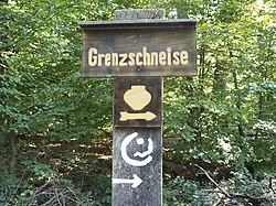
 Signpost with urn pictogram (center). Including the signet of the Frankfurt green belt |
|
| Data | |
| length | 11 km |
| location | South Main , in the Frankfurt city forest |
| Markers | beige pictogram of an Iron Age urn |
| Starting point |
Frankfurt-Schwanheim 50 ° 4 ′ 56.8 ″ N , 8 ° 34 ′ 51.5 ″ E |
| Target point | Frankfurt-Schwanheim 50 ° 4 ′ 56.8 ″ N , 8 ° 34 ′ 51.5 ″ E |
| Type | Circular hiking trail |
| Height difference | approx. 20 m |
| The highest point | 113 m on the Kelsterbach terrace |
| Lowest point | approx. 93 m at the Rohsee |
| Level of difficulty | light |
| season | all year round |
ATTENTION as of November 17, 2019
Die Beschilderung des Weges ist auf den ersten 6 km verwittert, lückenhaft und teilweise nicht mehr zu erkennen. Es ist also derzeit nicht möglich, den Wanderweg ohne Karte oder GPS zu gehen.
The historic Schwanheim hiking trail is an approximately eleven kilometer long educational trail and circular hiking trail in the city of Frankfurt am Main in the German state of Hesse . The total of 18 stations on the trail are located in places of particular importance for local history from the Paleolithic to the early 20th century. The technical focus of the educational trail is on archaeological , botanical and geological topics. At every station along the way, a text panel provides information about the historical significance of the place; the forest office of the city of Frankfurt offers a booklet with more detailed information.
Location of the hiking trail
The historic hiking trail Schwanheim lies over its entire length on the boundary of the southwestern Frankfurt district of Frankfurt, Schwanheim . Most of the route leads through wooded terrain in the north-western part of the Frankfurt city forest , known as the Schwanheimer Wald . This means that the hiking trail is also largely in the area of the landscape protection and local recreation area of the Frankfurt Green Belt . The difference in altitude to be covered on the way is around 20 meters, most of the route has no or only very slight inclines. The historic Schwanheim hiking trail is crossed at several points by the green belt circular hiking trail and the green belt circular cycling route; in the south of the historic hiking trail, its course is identical to that of the green belt circular hiking trail for a distance of around three kilometers.
Topics and requirements of the educational trail
The chronological order of the stations on the historical hiking trail begins with information on the geological history of the area from the last cold period from around 110,000 years before the Christian era to around 10,000 years ago (stations 3, 4 and 13 of the nature trail; see the following section The stations of the hiking trail ). The Kelsterbacher Terrasse site provides an insight into the formation of the site since the cold ages . The chronology of the stations continues with the first human traces on the area. A large number of archaeological finds have been made in the Schwanheim district since the late 18th century. The oldest traces of human use by the Schwanheimers, swamp and forest areas that belong to the sub- Maine level - finds of tools and weapons - come from the Paleolithic, with the Neolithic the number of finds increases (station 8). The earliest traces of permanent human settlement in the Schwanheim area are from the Bronze Age , including the remains of a total of four settlements and several hundred barrows (station 6). The latter are located along a path in the Schwanheimer Forest that still exists today, the Grenzschneise, which is the oldest known road connection in the Frankfurt city area (station 12). Other archaeological finds from the 2nd and 3rd centuries AD are of Roman origin (stations 15 and 16). In the absence of meaningful finds on site from the historical epochs known as the Middle Ages (the millennium from approx. 400 to 1400 AD), the chronology of the stations of the historical hiking trail continues with the beginning of the modern era . One focus is the development of the community Schwanheim since the 18th century (stations 1 to 4, 7 and 9, 10 and 18).
The information boards set up along the Schwanheim historical hiking trail at sites and historical relics should provide interested hikers with short texts an insight into the history and prehistory of the area; The Forest Office of the City of Frankfurt offers a 56-page booklet to deepen the topics, which contains detailed text information, drawings or photos as well as a map of the circular hiking trail for each of the stations on the educational trail. Many of the objects discovered over the years along today's educational trail are exhibited in the nearby Schwanheimer Heimatmuseum. The information boards on the historic hiking trail, the leaflet and the presentation of the exhibits in the museum complement each other didactically .
The stations of the hiking trail

The course of the historic hiking trail is signposted with wooden signposts. The pictogram of the hiking trail is the beige-colored outline of a vase-shaped urn . The model for the pictogram was a piece of grave pottery discovered in 1927 from a burial mound from the Hallstatt period - around 700–450 BC. - in the Schwanheim forest (station 6 of the educational trail). The eleven-kilometer stretch of the hiking trail can be shortened to a western and an eastern part at station 10 (Schwanheimer Bahnstrasse) .
1. Kobeltruhe (location: 50 ° 4 ′ 41 ″ N, 8 ° 34 ′ 51 ″ E )
Forest rest area and memorial for Wilhelm Kobelt (1840–1916), in 1869 the first resident doctor in the village of Schwanheim, zoologist ( malacology ) and local researcher. Author of the first chronicle of the place.
2. Schwanheimer Alteichen (location: 50 ° 4 ′ 56 ″ N, 8 ° 35 ′ 23 ″ E )
The Schwanheim old oaks are a group of around 30 pedunculate oaks , on average 500 years old , relics of the use of the Schwanheim forest as a hut forest . The Schwanheim old oaks were used as fruit trees, the fruits of which were used for cattle fattening ( acorn fattening ) .
3. Pfingstberg (location: 50 ° 4 ′ 41 ″ N, 8 ° 35 ′ 51 ″ E )
An approximately 50,000 year old sand dune on the northern edge of the city forest, created by sand drift. The name of the dune comes from the local customs - on since the 15th century with pine clad hills celebrated Schwanheimer citizens to the 19th century every year at Pentecost their Wäldchestag .
4. Tannenkopf (position: 50 ° 4 ′ 37 ″ N, 8 ° 36 ′ 3 ″ E )
A post-glacial sand dune on the northern edge of the city forest with the same geological and botanical history as the Pfingstberg .
5. Forsthaus Goldstein (location: 50 ° 4 ′ 36 ″ N, 8 ° 36 ′ 6 ″ E )
Revierförsterei 4 of the Forestry Office of the City of Frankfurt, located on Schwanheimer Bahnstrasse (see station 10). The booklet accompanying the hiking trail at this station deals with the history of the abandoned Goldstein moated castle from the 13th century, the emergence of the Goldstein settlement east of the forester's lodge, which was built in the 1930s, and the history of the Frankfurt Forest Railway in the 19th and 20th centuries 20th century.
6. Hell above the Wartweg - Barrows - At the Hell above the Wartweg there are several larger groups with up to 60 barrows from the Neolithic to the Bronze Age and the Pre-Roman Iron Age along the upper edge of the Kelsterbach terrace. During the archaeological excavations of some of the mounds, finds from the Hallstatt period were made (→ traces of settlement and burial mounds from the Bronze Age on the Kelsterbach terrace ) . The field name Helle or Hell, which has been preserved in the name Höllenweg to the present day, is a dialectic modification of the word Halde .
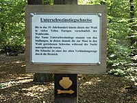
7. Unterschweinstiegschneise - The name of this forest aisle, which has been converted into a road, indicates that the area was used as a hut forest until the early 20th century, specifically for fattening pigs. The former names of the Unterschweinstiegschneise were Alter Hayn-Pfadt, Waadschneise and Wartweg .
8. Steep slope - finds from the Neolithic Age - on the Kelsterbacher Terrasse, a step in the terrain in the Schwanheim Forest (see station no. 13 on the hiking trail). In the late 19th century, several tools from the Neolithic Age were found while mining gravel and sand on the slope of the terrace . Further finds took place in the middle of the 20th century. The found objects are exhibited in the Schwanheimer Heimatmuseum (→ Finds of Stone Age tools on the Kelsterbach terrace ) .
9. Former Schwanheim gravel pit - gravel pit of the Schwanheim community, laid out in the 19th century. After the Second World War , the pit was filled with rubble from the air raids on Frankfurt am Main and planted with poplar and beech trees.
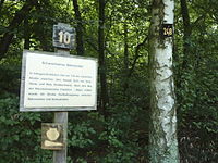
10. Schwanheimer Bahnstraße - a connecting road laid out in the 19th century between the village of Schwanheim in the north and the former Schwanheim train station, about two kilometers south of it . This was on the Frankfurt - Mainz railway line opened in 1862 (when the Hessische Ludwigsbahn opened , now the Mainbahn ). Archaeological finds on Schwanheimer Bahnstrasse indicate a Roman road with partially identical routes, possibly a connection between the northern Roman city of Nida and the Groß-Gerau fort , located in the Auf Esch district of today's district town of Groß-Gerau .
11. The Lichtetalschneise - valley cut in the west of the Kelsterbacher Terrasse, former water drainage from the slope into the lowland. The field name Lichte Tal (alternative spelling Lichtetal ) comes from the formerly loosened (light) vegetation and is now used as a name for the barrows located there, the Lichte-Tal-Gruppe (also Lichtetal-Gruppe ). The parcel belongs to the water catchment area of the Hinkelstein pumping station to the south , which is used to produce drinking water for the city of Frankfurt.
12. Boundary corridor and boundary stones - section of a historical trade route from Mainz to Aschaffenburg , oldest known road connection in the Frankfurt city area. The Schwanheimer Grenzschweise is lined with boundary stones from the 18th century as well as the remains of a border wall with an accompanying ditch.
13. Kelsterbacher Terrasse (location: 50 ° 4 ′ 21 ″ N, 8 ° 35 ′ 31 ″ E )
The Kelsterbacher Terrasse is an eight-kilometer-long step in the terrain, up to 17 meters high. The slope is a river terrace of a glacial valley of the river Main that was formed in the cold ages . The border aisle runs along the upper edge of the Kelsterbach terrace, where most of the barrows in the Schwanheim area are also located.
14. Riedwiese (location: 50 ° 4 ′ 30 ″ N, 8 ° 32 ′ 59 ″ E )
Marsh area along the Rohsee , a left arm of the Main in the west of the Schwanheim Forest, today a forest pond . During archaeological excavations on site, traces of settlement from the Bronze Age were found. Some of the finds excavated there are exhibited in the Schwanheimer Heimatmuseum.
15. Roman Villa Rustica (Location: 50 ° 4 ′ 42 ″ N, 8 ° 33 ′ 6 ″ E )
On the western edge of the Frankfurt urban area, on the municipal border with the city of Kelsterbach , the remains of the foundations of a Roman villa rustica were exposed during construction work on Bundesstraße 40 ("Kelsterbacher Spange") in 1972 . It is believed that this simply executed estate was destroyed around the year 260 AD during a conquest of the Germanic tribe of the Alamanni . The exposed, partially reconstructed remains of the foundation can be viewed on site.
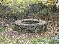
16. Roman stone fountain - About 30 meters away from the described Villa rustica there is a Roman fountain that was also found during road construction work. Archaeological digs in the well shaft unearthed a variety of finds, including a human skeleton. The finds allow an interpretation as a special burial ; the exhibits form the central point of the exhibition at the Schwanheim Local History Museum. After the excavations, the well shaft was backfilled with earth; The remainder of the natural stone fountain ring, which is around 30 centimeters high, can be viewed.
17. La Tène period - In 1968, graves with grave goods from the La Tène period as well as the bones and teeth of mammoths were found in a gravel pit on the western edge of the Schwanheim district .
18. Schwanheim village and field markings - The last station of the circular hiking trail is dedicated to the history of the town of Schwanheim - from the first documented mention in 880 AD until it was incorporated into Frankfurt in 1928.
Transport links
Due to its location in the forest, the Schwanheim Historic Hiking Trail is easiest to reach by public transport and by motorized private transport from the north, from the southern outskirts of Schwanheim. The first stop on the hiking trail, the Kobeltruhe, is just 500 meters south of the Rheinlandstraße stop of the Frankfurt transport company VgF . Rheinlandstraße is the final stop for lines 12 and 19 of the Frankfurt tram and the bus stop for bus lines 51, 62 and 73. The public car park closest to the historic hiking trail is located directly on its route; it is located at the Waldspielpark Schwanheim on Schwanheimer Bahnstrasse . Since the trail largely via not or hardly attached forest paths, which also have portions having average slopes in the southern part of the track, it is only over short distances limited accessibility .
literature
- City of Frankfurt am Main, Forestry Office (Hrsg.): Historischer Wanderweg Schwanheim - Wanderweg zur Schwanheimer history and prehistory . Booklet accompanying the nature trail with detailed information on its individual stations. Frankfurt, 2002
- City of Frankfurt am Main, Environment Agency (Ed.): The Green Belt Leisure Card . 7th edition, 2011
Web links
- Historic hiking trail Schwanheim at par.frankfurt.de , the former website of the city of Frankfurt am Main
- The historic Schwanheim hiking trail on the DVV hiking website (accessed on July 2, 2015)
Individual evidence
- ↑ a b Historischer Wanderweg Schwanheim, p. 6: Chapter course of the path
- ↑ a b Historic hiking trail Schwanheim, p. 50
- ^ City of Frankfurt am Main, Environment Agency (ed.): The green belt leisure map . 7th edition, 2011
- ^ City of Frankfurt am Main, Environment Agency (ed.): The green belt leisure map . 7th edition, 2011
- ^ Association 1100 Years of Schwanheim eV (Ed.): 1100 Years of Schwanheim - a festival book for the 1980 anniversary year of the Frankfurt district of Schwanheim, p. 11.
- ↑ a b Historic hiking trail Schwanheim, p. 5
- ↑ Ulrich Fischer: The barrows in the Schwanheim forest . Chapter in: Josef Henrich (Ed.): Suenheim - Sweinheim - Schwanheim, p. 19. Verlag Franz Jos. Henrich KG, Frankfurt am Main 1971
- ↑ Historischer Wanderweg Schwanheim, p. 8 f .: chapter Kobeltruhe
- ↑ Historic hiking trail Schwanheim, p. 10 f .: Chapter Schwanheimer Alteichen
- ^ City of Frankfurt am Main, Environment Agency, Green Belt Project Group (ed.): The Schwanheim old oaks in the Frankfurt Green Belt / RheinMain Regional Park . Leaflet, 2nd edition, 2009
- ↑ Historischer Wanderweg Schwanheim, p. 12: Chapter Pfingstberg
- ↑ Historischer Wanderweg Schwanheim, p. 13: Chapter Tannenkopf
- ↑ Historischer Wanderweg Schwanheim, p. 14 ff .: Chapter forester's house Goldstein
- ↑ Revierförstereien at par.frankfurt.de , the former website of the city of Frankfurt am Main
- ↑ Historischer Wanderweg Schwanheim, p. 20 ff .: Chapter Hell above the waiting path - barrows
- ↑ Historischer Wanderweg Schwanheim, p. 24 ff .: Chapter Unterschweinstiegschneise
- ↑ Historischer Wanderweg Schwanheim, p. 27 ff .: chapter steep slope - finds from the Neolithic Age
- ↑ Historischer Wanderweg Schwanheim, p. 30: Chapter Former Schwanheim gravel pit
- ↑ Historischer Wanderweg Schwanheim, p. 31 ff .: Chapter Schwanheimer Bahnstrasse
- ↑ Historischer Wanderweg Schwanheim, p. 35: Chapter The Lichtetalschneise
- ↑ Historischer Wanderweg Schwanheim, p. 36 ff .: Chapter boundary lane and boundary stones
- ↑ Historischer Wanderweg Schwanheim, p. 39 f .: Chapter Kelsterbacher Terrasse
- ↑ Historischer Wanderweg Schwanheim, p. 41 f .: Chapter Riedwiese
- ↑ Andrea Faber, Vera Rupp , Paul Wagner: The villa rustica in the "Heftgewann" near Frankfurt am Main-Schwanheim. In: Find reports from Hessen 32/33, 1992/93 (2000) pp. 129–197.
- ↑ Historischer Wanderweg Schwanheim, p. 45 ff .: Chapter Römischer Steinbrunnen ; on burial see Norbert Müller and Günter Lange: A human skeleton from the fountain of a villa rustica near Frankfurt aM-Schwanheim. In: Find reports from Hessen 15, 1975 (1977), pp. 315–326.
- ↑ Schwanheim historical hiking trail, p. 49: Chapter La Tène period
- ↑ Historischer Wanderweg Schwanheim, p. 50 ff .: Chapter village and field markings Schwanheim
- ^ Rhein-Main-Verkehrsverbund (RMV): General route plan for Frankfurt am Main, 2012 edition
- ↑ Historical treck Schwanheim at par.frankfurt.de , the former site of the city of Frankfurt am Main
- ^ City of Frankfurt am Main, Environment Agency (ed.): The green belt leisure map . 7th edition, 2011


