
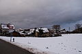
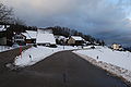
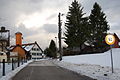
Hofstetten ZH
| Hofstetten | ||
|---|---|---|
 |
||
| State : |
|
|
| Canton : |
|
|
| District : | Winterthur | |
| Political community : | Elgg | |
| Postal code : | 8354 | |
| Coordinates : | 706 725 / 259 117 | |
| Height : | 644 m above sea level M. | |
| Area : | 8.85 km² | |
| Residents: | 498 (December 31, 2016) | |
| Population density : | 56 inhabitants per km² | |
| Mayor : | Roger Gerber ( independent ) | |
| Website: | www.elgg.ch | |
| map | ||
|
||


Hofstetten (until 2003 officially Hofstetten bei Elgg ) is a district of the municipality of Elgg in the Swiss canton of Zurich . Until December 31, 2017, it formed an independent political municipality .
The hamlets Dickbuch , Jakobstal, Geretswil, Huggenberg, Tiefenstein, Scheunberg, Steig and Wenzikon also belong to the former municipality of Hofstetten . Dickbuch, Hofstetten, Huggenberg, Geretswil and Wenzikon were independent civil parishes until 1928 .
coat of arms
- In gold a pinned black bar with lines in the wall, accompanied by five red stars (3, 2)
geography
Hofstetten is located between the Murg and Tösstal valleys north of the Schauenberg, on the eastern border of the canton of Zurich. 46% of the community area is covered with forest, 50% is used for agriculture.
The former municipality of Hofstetten bordered the town of Elgg in the north, Aadorf ( TG ) in the east, Bichelsee-Balterswil (TG) in the southeast, Turbenthal in the south, Schlatt in the west and Elsau in the north-west .
population
| Population development | |
|---|---|
| year | Residents |
| 1467 | approx. 90 |
| 1850 | 587 |
| 1900 | 478 |
| 1950 | 461 |
| 2000 | 419 |
| 2010 | 447 |
The main language is German with 98.6%, French 0.5% and Italian 0.25% of the population speak.
politics
The SVP has 66%, the SP 9.2%, EPP 7.5%, the FDP 6.7%, the Greens 3.1% and the CVP 1.1%
The last mayor was Roger Gerber ( non-party ).
history
Hofstetten is first attested in 914 as a Pipineshovestetin "at the court of the Pipin".
Today's Schauenberg ruins, above Hofstetten, date back to around 1200. It was the seat of a Saint Gall ministerial family , first mentioned in 1242 , was taken over by Beringer von Hohenlandenberg around 1331 and razed by the Austrians and Zurichers around 1344.
In 1424 (definitely 1452) Hofstetten and the County of Kyburg came to the city of Zurich by court order . In 1798 it became a political municipality; ecclesiastically it always belongs to Elgg.
On January 15, 2017, the voters in Hofstetten and Elgg decided that the political municipality of Hofstetten will be part of the municipality of Elgg from 2018.
Attractions
gallery
Hofstetten (the school on the right)
Geretswil
Huggenberg

Deep stone


literature
- Hans Martin Gubler: The art monuments of the canton of Zurich. Volume 7: The Winterthur district. Southern part (= Swiss art monuments. Volume 76). Edited by the Society for Swiss Art History GSK. Bern 1986, ISBN 3-7643-1786-8 , pp. 267-281.
- Ueli Müller: Hofstetten (ZH). In: Historical Lexicon of Switzerland .
Web links
- Official website of the municipality of Hofstetten ZH
- Statistical data from the canton on the municipality of Hofstetten ZH
Individual evidence
- ↑ Reto Flury: Community mergers: Elgg swallows Hofstetten . In: Neue Zürcher Zeitung . January 15, 2017, ISSN 0376-6829 ( nzz.ch [accessed January 22, 2017]).
Altikon | Brütten | Dägerlen | Dättlikon | Dinhard | Elgg | Ellikon an der Thur | Elsau | Hagenbuch | Hettlingen | Neftenbach | Pfungen | Rickenbach | Schlatt | Seuzach | Turbenthal | Wiesendangen | Winterthur | Cell
Former communities: Bertschikon | Hofstetten | Kefikon | Oberwinterthur | Lakes | Schottikon | Töss | Veltheim | Wülflingen
Canton of Zurich | Districts of the Canton of Zurich | Municipalities of the Canton of Zurich