High Forest (Rothaar Mountains)
| High forest | ||
|---|---|---|
|
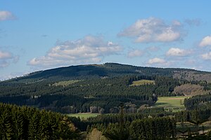
View from Brachthausen west-southwest to the Hohe Wald |
||
| height | 656.4 m above sea level NHN | |
| location | between Silberg and Rahrbach ( Olpe district ), Littfeld and Müsen ( Siegen-Wittgenstein district ), North Rhine-Westphalia ( Germany ) | |
| Mountains | Rothaar Mountains | |
| Dominance | 10.7 km → belt | |
| Notch height | 185.7 m ↓ north of Müsen | |
| Coordinates | 51 ° 1 '22 " N , 8 ° 1' 16" E | |
|
|
||
| particularities | Transmission tower | |
The high forest is 656.4 m above sea level. NHN high mountain of the Rothaargebirge and thus the highest mountain in the urban area of Kreuztal as well as the highest peak in the northern Siegerland . It is located near Burgholdinghausen in the Siegen-Wittgenstein district and in the Olpe district in North Rhine-Westphalia . During the Cold War there was a radio relay position on it.
geography
location
The Hohe Wald is a southwestern branch of the Rothaargebirge. It is located in the Sauerland-Rothaargebirge nature park between the Wolfshorn ( 643 m above sea level ) and the Kindelsberg ( 618.1 m above sea level ) in North Rhine-Westphalia. A few meters east of its summit, which is in the Burgholdinghausen district , the border runs between the Siegen-Wittgenstein district in the west and the Olpe district with the Kohlhagen district in the east. Most of the mountain is in the area of the Siegen-Wittgenstein district. The Hohe Wald is surrounded by the villages of Littfeld and Burgholdinghausen (southwest), Rahrbach and Welschen Ennest (northwest), Silberg (northeast) and Müsen (south-southeast).
Natural allocation
The high forest belongs to the natural spatial main unit group Süderbergland (No. 33), in the main unit Rothaargebirge (with Hochsauerland ) (333) and in the subunit Westrothaarhöhen (333.4) to the natural area Brachthäuser Hohe Waldberge (333.40, see section in the Rothaargebirgs article ). Its landscape falls to the south-west in the main unit Siegerland (331) and in the sub-unit North Siegerland Bergland (331.0) in the natural area Littfelder Grund (331.00) and to the north-west in the main unit Westsauerländer Oberland (336) and in the sub-unit South Sauerland Bergland (336.2) into the Rahrbachmulde (336 2 .510) belonging to the Fahlenscheid (336 2 .51) natural area .
Mountain height
The high forest is 656.2 m high. A trigonometric point at a height of 655.4 m is recorded on topographic maps about 35 m southeast of its summit .
Flowing waters
On the north-western slope of the Hohen Wald, some tributaries of the Littfe arise , the source of which lies in the northern transition area to the Wolfshorn, on its south-eastern slope a tributary of the Heimkaus (Heimkaus; Heiminkhaus) brook , and on the eastern transition area to the neighboring Silberg ( 547.2 m ) the Schladesiepen .
Protected areas
The Sellenbruch nature reserve (NSG) ( CDDA no. 82585; designated 1942; 16.98 hectares ) and the fauna-flora-habitat area Dollenbruch, Sellenbruch and Silberbach Oberlauf (FFH no. 4914- ) are located on the eastern flank of the High Forest . 302; 42 ha), which are located south of the village of Silberg. Parts of the NSG mine area and forests near Burgholdinghausen (CDDA no. 163392; 1991; 138.60 ha) and the FFH area mine area Littfeld (FFH no. 4914-303; 42 ha) extend to its southern flank . In the east, up to the high elevations of the mountain near the summit, parts of the Olpe district landscape protection area extend (CDDA no. 555555098; 1984; 262.5674 km² ).
Transmission tower
Broadband network
The emblem of the high forest is the transmission tower on its summit region . About the composite network nodes High Forest one is radio distance for the broadband network Südwestfalen operated.
Military use
Up until the 1990s there was a radio link for the Air Force on the Hohe Wald . During the Cold War, the Luftwaffe set up its own radio relay system and covered the area of the Federal Republic of Germany with radio relay stations . To the automatic guidance telecommunications network of the Air Force (AutoFüFmNLw) all use the major associations and command posts were connected. It consisted of two radio relay lines running from north to south. Command authorities, associations, units, depots and command posts that were not directly in one of these routes were connected to it with end routes.
The telecommunication stations were often far away from conventional barracks on high points in the landscape. The telecommunications regiment 11 , to which the radio relay switchboard Hoher Wald belonged, was responsible for the command support of the Air Force in the northern area of the Federal Republic of Germany. After German reunification and the onset of digitalization , this network was rebuilt, which led to the closure of the station on the Hohe Wald.
Belgian armed forces were stationed there in front of the Bundeswehr . Shortly after the end of the Second World War, the Belgian armed forces in Germany were stationed in a kind of corridor on the southern edge of the British occupation zone in western Germany, along a line from Aachen to Kassel.
Others
Hurricane Kyrill caused severe damage on the Hohe Wald in January 2007.
Individual evidence
- ↑ a b c d Topographical Information Management, Cologne District Government, Department GEObasis NRW ( information )
- ↑ Martin Bürgener: Geographical Land Survey: The natural spatial units on sheet 110 Arnsberg. Federal Institute for Regional Studies, Bad Godesberg 1969. → Online map (PDF; 6.1 MB)
- ↑ Map services of the Federal Agency for Nature Conservation ( information )
- ↑ Broadband coverage in the Siegen-Wittgenstein district ( Memento from December 22, 2014 in the Internet Archive ), in the original on siegen-wittgenstein.de (PDF; 1.52 MB)
- ^ The Bundeswehr 1989. Organization and equipment of the armed forces of the Federal Republic of Germany at the end of the Cold War. (PDF) (No longer available online.) Archived from the original on July 27, 2013 ; Retrieved April 25, 2016 . Info: The archive link was inserted automatically and has not yet been checked. Please check the original and archive link according to the instructions and then remove this notice. , on relict.com (PDF; 2.11 MB)
- ↑ Historical data of the telecommunications sectors of the Air Force ( Memento of the original from December 22, 2014 in the Internet Archive ) Info: The archive link was automatically inserted and not yet checked. Please check the original and archive link according to the instructions and then remove this notice. , on kameradschaft-ehemalige-3fmrgt11.de
- ↑ The Air Force radio relay network in southern Germany , on geschichtsspuren.de
- ↑ Command Support Battalion 285 ( Memento from December 23, 2014 in the web archive archive.today ) in The Armed Forces Base Services , as of November 25, 2013, from kommando.streitkraeftebasis.de
- ↑ The Belgian Armed Forces in Germany in the 1980s ( Memento of the original from October 28, 2007 in the Internet Archive ) Info: The archive link has been inserted automatically and has not yet been checked. Please check the original and archive link according to the instructions and then remove this notice. (Overview map), on museum-bsd.de
- ^ "Belgian Corridor" from Aachen to Kassel in: Belgian soldiers in Germany (Flandern-Info), from May 2, 2011, on deredactie.be


