
Hunolstein (Morbach)
|
Hunolstein
Association-free municipality of Morbach
|
||
|---|---|---|
 |
||
| Height : | 410 m above sea level NHN | |
| Residents : | 258 (Aug 31, 2008) | |
| Incorporation : | December 31, 1974 | |
| Postal code : | 54497 | |
| Area code : | 06533 | |
Location of Hunolstein in Rhineland-Palatinate |
||
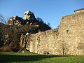
 View of the town of Hunolstein
|
||

Hunolstein is a village and local district in the western area of the community -free municipality Morbach in the district of Bernkastel-Wittlich in Rhineland-Palatinate and is located about 449 m above sea level. NHN . At the end of 1974, the previously independent community of Hunolstein was dissolved and the present-day community of Morbach was formed from it and 18 other communities.
geography
The street village is surrounded by the valleys of the Wahlholzbach , the Dhronbach and the Schalesbach . The Hunsrückhöhenstraße runs near the village .
The Hahnacker Hof, Hellenberger Hof, Hof auf Queckborn, Hunolsteinerhof and Schülersmühle residential areas also belong to Hunolstein.
history
In the immediate vicinity of the village is the former Hunolstein Castle , the ancestral seat of the bailiffs and lords of Hunolstein , which was built around 1190. It was conquered by Franz von Sickingen in 1522 and so badly destroyed by the French and Swedes during the Thirty Years' War that it was no longer inhabited from 1637.
Originally the residents settled in the village of Lampersberg, which is now only a field name near Hunolstein. The current place was settled around 1525.
In Hunolstein there used to be three mills: the Altmühle (located near today's Reinhardsmühle), the Schülersmühle in Dhronbachtal and the Reinhardsmühle. The Schülersmühle has been documented since 1264, the Reinhardsmühle since 1396.
The former Hunolsteiner Hof, which belonged to the castle, is located two kilometers southwest of the village.
The Catholic parish church was built in 1907 according to a design by the Koblenz architect Leopold Schweitzer and is dedicated to St. Consecrated Johannes Baptist . A wayside chapel from the 18th century is located south of the village on the road to Odert . The Walholzkirche with origins from the 12th century stands between Hunolstein, Weiperath and Odert in a meadow valley .
politics
Mayor is Marita Bernard.
The coat of arms of the former municipality of Hunolstein shows the entrance tower of the castle in gold and silver on a blue background. Heraldically to the right of the tower is a silver shield with a red bar cross - Kurtrier's coat of arms . To the left of the tower is a golden shield with two red bars and twelve red stones - the coat of arms of the Bailiffs of Hunolstein .
Culture
Regular events are the Carnival, the parish festival, the fair, the fire brigade festival and the Oktoberfest. Resident associations are the volunteer fire brigade , the SSV Dhrontal, the citizens' shooting club and several bowling clubs.
Economy and Infrastructure
In Hunolstein there is a full-time farmer , a farm cafe and the “Zur Traube” inn. Several hiking trails are signposted.
photos

Hunolstein Castle
Hunolstein Castle

church


literature
- Josef Knob: The village of Hunolstein . In: Communications on regional history and folklore in the districts of Trier and Koblenz 5 (1960), pp. 126-133 [Issue 3, September 1960].
Web links
Individual evidence
- ↑ Official municipality directory (= State Statistical Office of Rhineland-Palatinate [Hrsg.]: Statistical volumes . Volume 407 ). Bad Ems February 2016, p. 172 (PDF; 2.8 MB).
- ↑ State Statistical Office Rhineland-Palatinate (ed.): Official directory of the municipalities and parts of the municipality. Status: January 2018 [ Version 2020 is available. ] . S. 54 (PDF; 2.2 MB).