
Żurrieq
| coat of arms | map |
|---|---|

|
  |
| Basic data | |
| State : | Malta |
| Gzejjer : | Malta Xlokk (Southeast Malta) |
| Distretti : | South Eastern |
| Area : | 8,456,515 km² |
| Residents : | 10,962 (December 31, 2018) |
| Population density : | 1296 inhabitants / km² |
| ISO 3166-2 : | MT-68 |
| Postal code : | ZRQ |
| Website : | http://zurrieqlocalcouncil.com/ |
| politics | |
| Mayor : | Silvio Izzi Savona |
Coordinates: 35 ° 50 ' N , 14 ° 28' E
Żurrieq [ zʊrˈrɪːʔ ] (also: Iż-Żurrieq ) is one of the oldest cities in Malta and has 10,962 inhabitants (as of December 31, 2018). In 1436 it became its own parish, consecrated to Catherine of Alexandria .

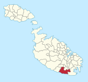
Żurrieq is located in the southeastern part of Malta. It is part of the 5th district and elections to the Local Council (city council) are every 3 years. The city council consists of 7 members; one of them is the mayor. Ignatius Farrugia is currently the mayor of Żurrieq.
Buildings
Attractions
The Blue Grotto ( Il-Ħnejja ) is known for its clear water and caves. Likewise, the Xarolla Windmill is a tourist destination with recently excavated catacombs nearby, bordering the village of Safi . The feast of the patron saint Catherine of Alexandria , celebrated on the first Sunday in September, is known for its fireworks and the statue. The second most important festival, that of Our Lady of Mount Carmel, is celebrated on the first Sunday after July 16th.
The city area also includes the rocky island of Filfla , five kilometers south of the coast , with its subsidiary island Filfoletta , which forms the southernmost land mass of Malta.
Town twinning
Żurrieq has partnerships with three cities:
-
 Angermünde , Germany
 -
 Borgo Maggiore , San Marino
 -
 Morfou , Cyprus
Web links
Individual evidence
- ↑ StatDB of the National Statistics Office Malta , accessed on August 1, 2020
Malta Island: Attard | Balzan | Birgu (Vittoriosa) | Birkirkara | Birżebbuġa | Bormla (Cospicua) | Dingli | Fgura | Floriana | Gudja | Gżira | Għargħur | Għaxaq | Ħamrun | Iklin | Isla (Senglea) | Kalkara | Kirkop | Lija | Luqa | Marsa | Marsascala | Marsaxlokk | Mdina | Mellieħa | Mġarr | Mosta | Mqabba | Msida | Mtarfa | Naxxar | Paola | Pembroke | Pietà | Qormi | Qrendi | Rabat | Safi | Saint Julian's (St. Julian's) | San Ġwann | San Pawl il-Baħar (St. Paul's Bay) | Santa Luċija | Santa Venera | Siġġiewi | Sliema | Swieqi | Ta 'Xbiex | Tarxien | Valletta | Xgħajra | Żabbar | Żebbuġ | Żejtun | Żurrieq
Gozo Island:
Fontana |
Għajnsielem |
Għarb |
Gasri |
Kerċem |
Munxar |
Nadur |
Qala |
Rabat (Victoria) |
San Lawrenz |
Sannat |
Xagħra |
Xewkija |
Żebbuġ
For some municipalities, the English name is also given in brackets.