Jindřišská
| Jindřišská | ||||
|---|---|---|---|---|
|
||||
| Basic data | ||||
| State : |
|
|||
| Region : | Ústecký kraj | |||
| District : | Chomutov | |||
| Municipality : | Jirkov | |||
| Area : | 383.2132 ha | |||
| Geographic location : | 50 ° 31 ' N , 13 ° 25' E | |||
| Height: | 525 m nm | |||
| Residents : | 29 (2011) | |||
| Postal code : | 431 11 | |||
| License plate : | U | |||
| traffic | ||||
| Street: | Jirkov - Boleboř | |||
Jindřišská ( German Hannersdorf ) is a district of the city of Jirkov in the Czech Republic .
geography
Jindřišská is three kilometers northwest of the city center of Jirkov on the southern slope of the Bohemian Ore Mountains on a ridge between the Telšské údolí ( Töltschtal ) of the Bílina and the valley of the Jirkovský potok. The Široký kámen ( Breitenstein , 543 m) rises to the north and the Na Skalce ( Wachhübel , 541 m) to the east . The Jirkov drinking water dam lies to the southwest , and the remains of the Najštejn castle lie above it . To the southeast is the Červený Hrádek Castle .
Neighboring towns are Orasín, Boleboř and Pyšná in the north, Drmaly in the east, Červený Hrádek and Jirkov in the south-east, Vinařice and Březenec in the south, Hrádečná and Šerchov in the south-west, Blatno , Květnov and Radeníř in the west and Telš and Meziř in the north-west.
history
It is unknown when the place was founded. According to old chronicles, the village is said to have initially belonged to Hassenstein Castle . Hainstorff was first mentioned in 1357 as the property of Neu Seeberg Castle . In 1383 Otto von Bergow sold his castles Alt Seeberg and Neu Seeberg am Thimo von Colditz . In 1395 the Lords of Colditz pledged Neu Seeberg with all accessories to Albrecht von Leisnig . The next pledgee was Heinrich von Ruenice . In 1437 Veit von Schönburg acquired the Seeberg rule. In 1454 he sold it to Albert Konipas on Bořek , who connected the newly acquired property to his Bořek castle. In the course of time, the name of the village changed via Hennerstorf , Hanersdorf , Heinersdorf and Hännersdorff to Hannersdorf . In the 16th century, the place died out completely due to a plague epidemic and was repopulated by Weingarten . The oldest surviving document from Hannersdorf in a sales contract from 1565. In 1579, Christoph von Carlowitz sold Hannersdorf together with Weingarten to the Hagensdorf rulership , which attached the village to Gut Göttersdorf . Gut Göttersdorf was temporarily attached to the Priesen dominion , but then came back to Hagensdorf in 1680. In 1787 Hannersdorf consisted of 23 houses and had about 170 inhabitants. Its inhabitants lived from growing grain and flax, weaving and knitting. In the Töltschtal, the water from the Biela drove four woodturning shops.
After the abolition of patrimonial Hannersdorf formed a political community in the Komotau district administration from 1850 onwards. In 1868 the village was incorporated into Görkau together with Weingarten. Quartzite quarries were operated in the vicinity of the place and gneiss was also broken as a building block. On September 22nd, 1870 a large fire broke out in Hannersdorf due to the carelessness of some boys, which destroyed a quarter of the village. The road to Görkau was built between 1877 and 1882, previously the village could only be reached via dirt roads from the road from Rothenhaus to Kallich . In 1881 the forest path from Weingarten to Göttersdorf was established, the hiking path offered a good view of the Töltschtal and Görkau. In 1892 the mountain association built a wooden lookout tower on the Wachhübel. This occurred after the First World War. In the years 1935 to 1937 Hannersdorf was independent and then became part of Görkau again.
After the Munich Agreement , the village was added to the German Reich in 1938 and belonged to the Komotau district until 1945 . After the end of the Second World War, Hannersdorf came back to Czechoslovakia and the German residents were expelled . Between 1945 and 1947 there were several arson attacks in the area, and the inn with the dance hall also burned down during this time.
On April 25, 1952, the name was changed to Jindřišská. Between 1960 and 1965, the Jirkov drinking water reservoir was built in the Töltschtal west of the village. In 2001 the village consisted of 7 houses in which 14 people lived. 14 chalets serve as holiday homes. The main tourist route, the forest road from Vinařice to Boleboř, was revived after 2000. In 2005 the construction of a 12 high wooden observation tower with a stone foundation wall on Na Skalce was approved. Construction should take place when funds are available for it.
Development of the population
|
|
|
Attractions
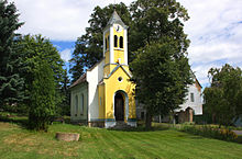
- Chapel of St. Nepomuk, donated in 1732 as a bell tower by Maximilian Quidobaldi Martinic and converted into a chapel in 1909
- Karlshöhe, viewpoint of the Jirkov dam and the remains of the Neustein Castle above the dam
- Červený Hrádek Castle , southeast of the village
Individual evidence
- ↑ http://www.uir.cz/katastralni-uzemi/660833/Jindrisska
- ↑ a b Historický lexikon obcí České republiky - 1869-2015. Český statistický úřad, December 18, 2015, accessed on January 17, 2016 (Czech).


