Kalayaan (Laguna)
| Municipality of Kalayaan | ||
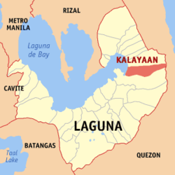
| Location of Kalayaan in Laguna Province | ||
|---|---|---|

|
||
| Basic data | ||
| Region : | CALABARZON | |
| Province : | Laguna | |
| Barangays : | 3 | |
| District: | 4. Laguna District | |
| PSGC : | 043409000 | |
| Income class : | 4. Income bracket | |
| Households : | 3788 May 1, 2000 census
|
|
| Population : | 23,269 August 1, 2015 census
|
|
| Coordinates : | 14 ° 21 ′ N , 121 ° 34 ′ E | |
| Postal code : | 4015 | |
| Geographical location in the Philippines | ||
|
|
||
Kalayaan is a Filipino municipality in Laguna Province .
geography
The parish area is rectangular in shape, with a hilly landscape in the easternmost area. The western part, on the other hand, is relatively flat. The highest peaks are between 400 and 418 meters high, these are in Sitio Santo Angel, Malaking Pulo, and Cabuhayan in Barangay San Juan and Sitio Lamao in Barangay San Antonio. About three quarters of the area is more than 300 meters high. The lowest lying areas are in the west in the barangays San Juan and Longos towards Laguna de Bay . The Caliraya and Lumot Lakes are located in parts of the municipality .
Kalayaan is politically divided into three barangays : Longos, San Antonio, and San Juan (Poblacion).
