Kambia (District)
|
||||
| motto | ||||
| Basic data | ||||
|---|---|---|---|---|
|
Area (in km² ) Population Population density (per km² ) |
3108 346,213 111.4 |
|||
|
State Province Chiefdoms (number) Constituencies (number) Wards (number) |
Sierra Leone North West 7 6 |
|||
| Establishment date | ||||
| Website | ||||
|
Political data
Administrative headquarters: Kambia Administrative Chairman: Election: district chairmen, local councils |
|
Geographical data
|
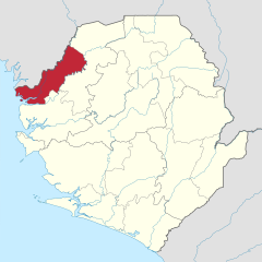
Kambia is a district of Sierra Leone with 346,213 inhabitants (as of 2020). It is located in the North West Province in the northwest of the country, on the Atlantic coast and the border with Guinea . Its capital is Kambia with about 11,800 inhabitants. Other cities are Rokupr , Kukuna , Mambolo and Kasiri .
The district covers an area of 3,108 square kilometers.
The inhabitants of the Kambia district are mainly of the Susu , Limba and Temne ethnic groups and the majority are Muslims. The economy in Cambia consists of small-scale mining and agriculture (livestock, arable farming, especially cashew nuts ).
Individual evidence
- ↑ population. GoSL Integrated GIS Portal. Retrieved May 14, 2020.
- ↑ Sierra Leone Encyclopedia 2006: Kambia District (Engl.)
Coordinates: 9 ° 7 ′ N , 12 ° 55 ′ W


