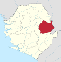
Kono (district)
|
||||
| motto | ||||
| Basic data | ||||
|---|---|---|---|---|
|
Area (in km² ) Population Population density (per km² ) |
5641 505,174 89.6 |
|||
|
State Province Chiefdoms (number) Constituencies (number) Wards (number) |
Sierra Leone Eastern 14 8 |
|||
| Establishment date | ||||
| Website | ||||
|
Political data
Administrative headquarters: Koidu Administrative Chairman: Election: district chairmen, local councils |
|
Geographical data
|
Kono is a district of Sierra Leone with 505,174 inhabitants (as of 2020). It is located in the Eastern province in the east of the country, on the border with Guinea . Its capital is Koidu , other cities are Yengema and Motema . The district is divided into 14 chiefdoms (chiefdoms).
Kono covers an area of 5,641 km². The Sankabiriwa in the Tingi Hills is the highest point in Kono and the second highest in all of Sierra Leone.
The most important ethnic groups in the Kono district are the Kono , Mende , Kissi and Temne . The economy in Kono consists of diamond and gold mining, rice cultivation, coffee and cocoa plantations. Before the civil war in Sierra Leone , Kono was the country's “bread basket”.
Not least because of its diamond deposits ( see also : blood diamonds ) Kono was one of the areas most severely affected by the civil war. Kono was the only district with fewer inhabitants in 2004 than in 1985 (389,657). Today, as in other parts of the country, reconstruction is under way. Diamond mining should also increasingly benefit the population and the development of the region.
In 2006, the district had 69 health facilities, including a government hospital, a mission and an NGO clinic, and four private clinics. In 2005, 1% of residents were HIV positive. In 2004/2005 there were 187 primary and 18 secondary schools. The literacy rate in 2004 for the city of Koidu was 42% (49% for men and 32% for women), in the rest of the district it was 27% (men 35%, women 19%). 45.2% of the children in Koidu and 42.3% in the rest of Kono attended school.
Individual evidence
- ↑ population. GoSL Integrated GIS Portal. Retrieved May 14, 2020.
- ↑ a b Statistics Sierra Leone: Final Results, 2004 Population and Housing Census ( Memento of February 15, 2010 in the Internet Archive ), 2006, p. 2f. (English, PDF)
- ↑ a b Statistics Sierra Leone: Annual Statistical Digest 2005/06 ( Memento of November 13, 2009 in the Internet Archive ), 2008, pp. 2, 22, 42, 50, 52 (English, PDF)
- ↑ a b c Sierra Leone Encyclopedia 2006: Kono District (Engl.)
- ↑ USAID: 'Peace Diamonds' from Sierra Leone ( Memento of November 8, 2006 in the Internet Archive )
- ↑ Albert CT Dupigny, Ibrahim Kargbo G., Alimamy Yallancy: Republic of Sierra Leone, 2004 Population and Housing Census. Analytical Report on Education and Literacy ( Memento of November 13, 2009 in the Internet Archive ), 2006, pp. 16, 22 (PDF)
Coordinates: 8 ° 36 ′ N , 11 ° 4 ′ W


