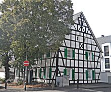
Kaule (Bergisch Gladbach)
Kaule is a district of Bergisch Gladbach and belongs to the statistics district 5 of the city under No. 54.
history
The name Kaule goes back to the original settlement centers of three medieval farmsteads with the name "auf der Kaule" in the Bensberg freedom . In the 17th century there were ten goods in the Kaule area. A large hamlet with 47 residential buildings and 286 inhabitants developed by the beginning of the 19th century.
The name of the settlement is etymologically derived from the Middle High German "kûle" (= pit) and refers to an artificially created depression from which ore, sand, gravel or clay was extracted. In this context, the street name “Am Pangenfeld” near the Albertus-Magnus-Gymnasium is interesting. As old aerial photos show, there was a larger ping field in this area. A pinge is a bowl-shaped or funnel-shaped depression in the terrain that was created by mining close to the surface. It is known that mining was carried out here in the High Middle Ages. So the street should actually be called Am Pingenfeld. Mining has also been dominant since the mid-19th century with the Julien mine, which was lent for lead and zinc ore . Around 1.4 million tons of ore that can be mined are still stored there today.
population
According to the EDP population register, Kaule had a total of 3,802 residents on June 30, 2017 (including 361 foreigners). The age group over 65 years with 940 inhabitants (including 42 foreigners) was stronger than the age group under 18 years with only 658 inhabitants (including 57 foreigners).
See also
Individual evidence
- ^ A b Andree Schulte Bergisch Gladbach, City History in Street Names , p. 297 ff., Bergisch Gladbach 1995, ISBN 3-9804448-0-5
- ↑ Willi Ommer. The hereditary homage in the Bergisches Amte Porz from 1666. Meerbusch, self-published July 2003, 273 pages
- ↑ Anon. Homage lists Bensberg Kaule 1666 and 1731, transcript; no date , accessed January 18, 2020
- ^ Herbert Stahl (editor), Das Erbe des Erzes, Volume 2, The pits on the Gangerz deposits in the Bensberg ore district . Cologne 2004, ISBN 3-00-014668-7 , p. 92 ff.
- ^ Statistics - City of Bergisch Gladbach. Retrieved July 26, 2017 .
Web links
- Max Morsches. The Kaule in Bensberg . Archive of the Bergisches Geschichtsverein Rhein-Berg 2007, accessed on January 18, 2020
Coordinates: 50 ° 58 ' N , 7 ° 10' E


