Kersbach (Forchheim)
|
Kersbach
City of Forchheim
Coordinates: 49 ° 40 ′ 55 ″ N , 11 ° 4 ′ 16 ″ E
|
|
|---|---|
| Height : | 275 m |
| Residents : | 2292 (Dec. 30, 2016) |
| Incorporation : | January 1, 1978 |
| Postal code : | 91301 |
| Area code : | 09191 |
Kersbach is a parish village in the Bavarian administrative district of Upper Franconia and the southernmost district of the large district town of Forchheim .
geography
The center of Kersbach is four kilometers south of the historic town center of Forchheim, in the southern part of Upper Franconia on the border with Middle Franconia in northern Bavaria , at the foot of Franconian Switzerland . Larger cities in the vicinity are Erlangen (≈ 11 km south), Nuremberg (≈ 26 km south) and Bamberg (≈ 27 km north).
Neighboring communities
The following communities border on Kersbach (starting in the east, clockwise ): Pinzberg , Effeltrich , Poxdorf , Baiersdorf and Hausen (near Forchheim) .
history
The name Kersbach goes back to the old German name for cherry ( Kîrsa , mhd. Kyrse, kirse, kerse ) and means at the brook where there are cherries. "Kyrsebach" was mentioned for the first time in a document from Emperor Heinrich II. From October 26, 1017, given to Allstedt . In it, Heinrich confirmed, at the request of the bishops Heinrich I of Würzburg and Eberhard I of Bamberg, an exchange contract between the two dioceses, with which the "abbaciam Erlangun ( Erlangen ), Forchheim, Eggolvesheim ( Eggolsheim ) and Kyrsebach (Kersbach) ... continue to receive the tithe the villages that now and once belong to Holevelt ( Hollfeld ) ... “came into the possession of the Bamberg diocese .
Originally the church was only dedicated to Saint John the Baptist . After the parish came into possession of a relic of St. Ottilie through a donation from Emperor Charles IV in 1356 , the church was placed under the first patronage of the patron saint of the eye-sick and blind . As a result, Kersbach was a pilgrimage site for Ottilien until the 20th century .
The formerly independent municipality of Kersbach and its district Sigritzau were incorporated into Forchheim in the course of the municipal reform in 1978. On March 2, 2007, 2062 residents were registered with their main or sole place of residence.
On July 21, 2007, Kersbach was hit by a flood, which also caused major property damage in several communities in the area.
The name Sigritzau comes from Sigehardesawe (to the Aue des Sigehard). "Sigritzau" was first mentioned in a document in 1238.
Culture and sights
Buildings
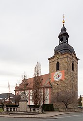
The most striking building in Kersbach is the Catholic St. Ottilien Church in the town center, which is bordered by the church square with a village fountain. The court and dance linden tree is also located in the center of the village . There is a chapel to the west on the road towards the train stop . In the south of the village, the bakery was built by the Franconian Village and Culture Association. V. with the help of the Directorate for Rural Development Bamberg.
Monuments
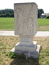
In the town center there is a war memorial on the main street with the names of the Kersbach citizens who died in the First and Second World Wars. At the end of the village in the direction of Effeltrich , a hall monument was erected in 2005 as part of the land consolidation on the right-hand side next to the oven .
Events
- January: Kersbacher Dreikönigslauf
- Weekend after Ascension Day : parish fair
societies
The DJK / TSV Kersbach offers football, acrobatics, dance, table tennis, mountain biking as well as various gymnastics and gymnastics sports. The first team in the football division played in the District League North from 1996 to 2002. She currently plays in the district league of the BFV . The association has organized the Dreikönigslauf annually since 1986.
Economy and Infrastructure
traffic
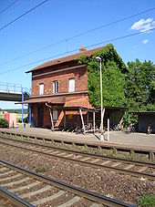
On the A73 Kersbach connection has to the motorway network . Since 2010, Kersbach has had a stop for the Nuremberg S-Bahn (line S1) on the Fürth – Bamberg railway in the west , just under a kilometer away. The level crossing on the same rails was replaced by a bridge in 2004.
The place is connected to the bus route Neunkirchen am Brand - Forchheim (VGN 224) and the train stop is connected to the bus route Oesdorf- Heroldsbach- Forchheim (VGN 216). Kersbach can be reached in around 30 minutes from Nuremberg International Airport .
The Franconian Marienweg runs through Kersbach .
Established businesses
Tree nurseries have a long tradition in Kersbach . Today, however, there is only one tree nursery and two gardening and landscaping companies that have emerged from tree nurseries . A beverage distributor has relocated its headquarters to the Sandäcker industrial estate. An electrotechnical factory is also represented there after a partial relocation. The good transport connections led to the settlement of commercial enterprises with high space consumption per workplace: Obi moved to Straße Am halben Weg, and three logistics service providers were added.
Public facilities
There is a three-group kindergarten in Kersbach and an affiliated crèche with 24 childcare places for children under 3 years of age. The primary school with four grade levels is affiliated with the Martinsschule in Forchheim. From September 1969 up to and including the 2008/2009 school year, it was part of the primary and secondary secondary school II Poxdorf . After primary school, the students from Kersbach have the opportunity to switch to a secondary school in Forchheim.
Leisure and sports facilities
In Kersbach there is a multi-purpose hall in addition to the school gym, the outdoor facilities of the DJK-TSV Kersbach and three children's playgrounds.
Sons and daughters of Kersbach
- David Lugert (* 1981), German singer in the band Viva Voce
Web links
- Private website for Kersbach
- Foracheim 1248 , information on local history
- Kersbach in the location database of the Bavarian State Library Online . Bavarian State Library
Individual evidence
- ^ Federal Statistical Office (ed.): Historical municipality directory for the Federal Republic of Germany. Name, border and key number changes for municipalities, counties and administrative districts from May 27, 1970 to December 31, 1982 . W. Kohlhammer GmbH, Stuttgart and Mainz 1983, ISBN 3-17-003263-1 , p. 684 .
- ↑ Broadcast from tvo ( Memento of the original from December 1, 2010 in the Internet Archive ) Info: The archive link was inserted automatically and has not yet been checked. Please check the original and archive link according to the instructions and then remove this notice.
- ↑ "Mouthwork" at its best. www.nordbayern.de, March 2, 2009, accessed October 8, 2018 .


