Keuperkusen
|
Keuperkusen
City of Attendorn
Coordinates: 51 ° 9 ′ 55 ″ N , 7 ° 52 ′ 10 ″ E
|
||
|---|---|---|
| Residents : | 10 (Jun 30, 2018) | |
| Postal code : | 57439 | |
| Area code : | 02722 | |
|
Location of Keuperkusen in North Rhine-Westphalia |
||
|
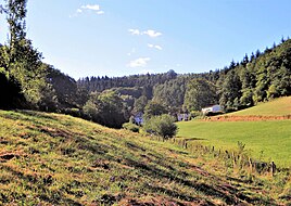
View of the Keuperkusen residential area
|
||
Keuperkusen is a residential area in the town of Attendorn in the Olpe district ( North Rhine-Westphalia ) and has 10 residents.
geology
Keuperkusen is located northwest of the core town of Attendorn on the border with the Märkischer Kreis . The place can only be reached via the L 697 behind the district border in Plettenberg - Lettmecke via Keuperkuser Weg. The Keuperkuser Bach flows through the village. Attendorn neighboring districts are southwest Lichtringhausen and Windhausen .
history
Keuperkusen was first mentioned in 1530 as Koperchusen . The place name can be interpreted as " at the houses of the people of Gōtberath ". Politically, Keuperkusen formerly belonged to the Waldenburg office and in the Gogericht and parish Attendorn to the Windhausen peasantry , which also includes surrounding places such as Hebberg , Lichtringhausen, Windhausen and the like. a. belonged to. In the treasury register of 1543, a Jacob Peters zu Keiperinghaußen with a tax of ½ gold guilders is named in the Winterhuißer Burschektiven with 21 taxpayers .
In the 17th century the Keuperkusen farm was called Schultenhof and belonged to the choir chapter in Attendorn, managed by Degenhard zu Keuperkusen. The Keuperkus family stayed on the farm until the middle of the 18th century. At the beginning of the 19th century, the Heller family owned the property. In the 1920s, writes Pickert, there were two owners, Johann Bausmann and Wilhelm Wurm. Later the forester and farmer Friedhelm Siepe (1934–2017) was the owner of the farm, married to Margret geb. Luke from Ennest .
The address book from 1929 in Keuperkusen lists the names "Bausmann (3), Siepe and Wurm (2)". In 1936 there were 2 houses and 16 residents in Keuperkusen. The address book from 1956 lists the names "Bausmann, Keseberg, Siepe (3) and Wurm". At the end of 1988 the residential area had 10 residents.
From 1819 Keuperkusen in the Attendorn office belonged to the Attendorn-Land municipality until the municipality was incorporated into the city of Attendorn in 1969.
To the south of the village there is a high-altitude hiking trail with a resting place and a lookout point at Vierkreuze at 491 m above sea level .
Religion, associations
Keuperkusen belongs to the parish of St. Antonius in nearby Windhausen, sports and club life take place in the larger neighboring towns.
Individual evidence
- ↑ Population statistics of the city of Attendorn (as of June 30, 2018) , accessed on August 4, 2018.
- ^ Albert K. Hömberg: Documents from the family archive v. Plettenberg-Lehnhausen , in: Heimatstimmen aus dem Kreis Olpe No. 17 (1955), pages 982–995
- ↑ Michael Flöer: The place names of the district of Olpe , in: Westfälisches Ortsnamenbuch, Volume 8, Bielefeld 2014, page 154
- ↑ Estimation register from 1543, page 69 [1]
- ↑ Julius Pickert: The farms of the Attendorn parish in the 17th century , in: Heimatblätter des Kreis Olpe, 4th century. 1926/27, page 53
- ↑ Hubert Luke: 100 years of the Luke family in Biekhofen 1896 - 1996 , self-printed 1997, page 7
- ↑ Official address book of the Olpe district 1928/29, section Attendorn-Land municipality, page 84
- ↑ Official residents' register of the district of Olpe 1938, Attendorn Office, page XV
- ↑ Home address book of the Olpe district, Münster 1956, section Attendorn-Land parish, page 155
- ^ Association for Orts- und Heimatkunde Attendorn eV, bulletin no. 14 (1990), page 15


