Koberovy
| Koberovy | ||||
|---|---|---|---|---|
|
||||
| Basic data | ||||
| State : |
|
|||
| Region : | Liberecký kraj | |||
| District : | Jablonec nad Nisou | |||
| Area : | 874.3663 ha | |||
| Geographic location : | 50 ° 37 ' N , 15 ° 14' E | |||
| Height: | 407 m nm | |||
| Residents : | 1,036 (Jan 1, 2019) | |||
| Postal code : | 468 22 | |||
| License plate : | L. | |||
| structure | ||||
| Status: | local community | |||
| Districts: | 8th | |||
| administration | ||||
| Mayor : | Jindřich Kvapil (as of 2007) | |||
| Address: | Koberovy 140 468 22 Železný Brod |
|||
| Municipality number: | 563641 | |||
| Website : | www.koberovy.cz | |||
Koberovy (German Koberwald ) is a municipality with 958 inhabitants (January 1, 2004) in the Czech Republic . It is 407 m above sea level. M. in the northern part of the Bohemian Paradise between the towns of Turnov and Železný Brod .
The place, first mentioned in 1323, is located in an area rich in cultural and natural monuments. Due to the largely untouched nature, Koberovy is a popular destination.
Community structure
The municipality of Koberovy consists of the districts Besedice (Bessetitz) , Chloudov (Chlodow) , Hamštejn (Hamstein) , Koberovy (Koberwald) , Michovka (Michowka) , Prosíčka (Prositschka) , Vrát (Wrat) and Zbirohy (Sbiroch) .
The municipality is divided into the cadastral districts Besedice, Koberovy and Vrát.
Attractions
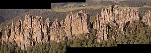
- Suché skály natural monument near Besetice and Vrát
- Zbiroh Castle near Zbirohy
- Hrubý Rohozec Castle in Turnov
Web links
Commons : Koberovy - collection of images, videos and audio files


