
Železný Brod
| Železný Brod | |||||
|---|---|---|---|---|---|
|
|||||
| Basic data | |||||
| State : |
|
||||
| Region : | Liberecký kraj | ||||
| District : | Jablonec nad Nisou | ||||
| Area : | 2251.6908 ha | ||||
| Geographic location : | 50 ° 39 ′ N , 15 ° 15 ′ E | ||||
| Height: | 305 m nm | ||||
| Residents : | 6,069 (Jan 1, 2019) | ||||
| Postal code : | 468 22 - 468 34 | ||||
| License plate : | L. | ||||
| traffic | |||||
| Railway connection: |
Pardubice – Liberec Železný Brod – Tanvald |
||||
| structure | |||||
| Status: | city | ||||
| Districts: | 12 | ||||
| administration | |||||
| Mayor : | Václav Horáček (as of 2007) | ||||
| Address: | náměstí 3. května 1 468 22 Železný Brod |
||||
| Municipality number: | 563871 | ||||
| Website : | www.zeleznybrod.cz | ||||


Železný Brod (German Eisenbrod ) is a town in Liberecký kraj in the Czech Republic . It is located in northern Bohemia in the Okres Jablonec nad Nisou on the right of the Jizera on the Pardubice – Liberec railway line . Due to its convenient length, it is a suitable starting point for trips to the Giant Mountains , the Jizera Mountains and the Český ráj protected area .
history
Železný Brod is an old glassmaking town, founded in the 11th century. Originally it was called Brod or Brodek (ford or small ford); It was not until the 14th century that the name Železný (iron) was added, which should refer to the local ironworks. In 1501 the city coat of arms was created and the place was named a city by King Vladislav II . In 1880 Železný Brod had 2698 inhabitants and was the seat of the district court. The cotton mill worked with 50,000 spindles.
In Železný Brod today, jewelery shops and the production of sheet glass , thermometers and small glass products such as glass figurines play an important role.
City structure
The town of Železný Brod consists of the districts Bzí (Nabsel) , Horská Kamenice (Gebirgskamnitz) , Hrubá Horka (Großhorka) , Chlístov (Chlistow) , Jirkov (Jirkau) , Malá Horka (Kleinhorka) , Pelechov (Pelechowils) , Splzov (Spechow) , Střevelná (Strewelna) , Těpeře (Tiepersch) , Veselí (Wesseli) and Železný Brod (Eisenbrod) . Basic development units are Brodec (Brodetz) , Bzí, Černická skála, Dvírka, stráň Horecká, Horská Kamenice, Hrubá Horka, Chlístov, Jiráskovo nábřeží, Jirkov, Křiby Mala Horka, Pelechov, Popluž (Poplus) , Poříčí, Propastný, Splzov, Střevelná, Těpeře, Těpeřská stráň, Veselí, Vrší, Záskalí and Železný Brod-střed.
The municipality is divided into the cadastral districts of Bzí u Železného Brodu, Horská Kamenice, Hrubá Horka, Chlístov u Železného Brodu, Jirkov u Železného Brodu, Střevelná and Železný Brod.
Attractions
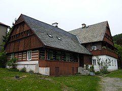
- In the town of Železný Brod there is the Village Monument Zone (Vesnické památkové rezervace) Trávníky (founded in 1754), with many buildings of a village folk architecture
- The “Klemencovsko” house is the seat of the city museum with a glass exhibition and a gallery of world-famous glass artists: J. Brychtová and S. Libenský
- The house "Běliště" (1807) is the most beautiful and largest building with a collection of sculptures
- Church of St. John Nepomuk
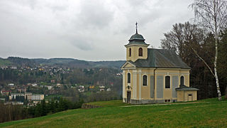
- Church of St. Jacob

Typical wooden house in Trávníky

Klemencovsko House
House Běliště
Church of Saint John Nepomuk

Church of Saint Jacob


sons and daughters of the town
- Johann Joseph Antonius Eleazar Kittel (1704–1783), doctor and natural healer, known as Dr. Faust von Schumburg , born in Nabsel.
Web links
Individual evidence
- ↑ http://www.uir.cz/obec/563871/Zelezny-Brod
- ↑ Český statistický úřad - The population of the Czech municipalities as of January 1, 2019 (PDF; 7.4 MiB)
- ↑ http://www.uir.cz/casti-obce-obec/563871/Obec-Zelezny-Brod
- ↑ http://www.uir.cz/zsj-obec/563871/Obec-Zelezny-Brod
- ↑ http://www.uir.cz/katastralni-uzemi-obec/563871/Obec-Zelezny-Brod