Rychnov u Jablonce nad Nisou
| Rychnov u Jablonce nad Nisou | ||||
|---|---|---|---|---|
|
||||
| Basic data | ||||
| State : |
|
|||
| Region : | Liberecký kraj | |||
| District : | Jablonec nad Nisou | |||
| Area : | 1225.2977 ha | |||
| Geographic location : | 50 ° 41 ' N , 15 ° 9' E | |||
| Height: | 435 m nm | |||
| Residents : | 2,749 (Jan 1, 2019) | |||
| Postal code : | 468 02 | |||
| License plate : | L. | |||
| traffic | ||||
| Street: | Jablonec nad Nisou - Hodkovice nad Mohelkou | |||
| Railway connection: | Liberec - Turnov | |||
| structure | ||||
| Status: | city | |||
| Districts: | 2 | |||
| administration | ||||
| Mayor : | František Chlouba (status: 2007) | |||
| Address: | Husova 490 468 02 Rychnov u Jablonce nad Nisou |
|||
| Municipality number: | 563790 | |||
| Website : | www.rychnovjbc.cz | |||
Rychnov u Jablonce nad Nisou (German Reichenau or Reichenau bei Gablonz an der Neisse ) is a town in the Jablonec nad Nisou district in the Czech Republic .
Geographical location
The city is located in northern Bohemia in the Jizera Mountains in the Mohelka Valley , five kilometers south of Jablonec nad Nisou ( Gablonz ). At the northern edge of the motorway runs R65 Jablonec towards Turnov ( Turnau ). Rychnov is on the Pardubice – Turnov – Liberec railway line , which runs into the city in a four-kilometer loop on both sides of the Mohelka.
Neighboring towns are Dolní Dobrá Voda and Dobrá Voda in the north, Kokonín and Maršovice in the northeast, Dalešice in the east, Pulečný in the southeast, Zálesi and Košovy in the south, Bezděčín and Pelíkovice in the southwest and Rádlo in the northwest.
history
middle Ages
The place was probably created by the Cistercian monastery Münchengrätz in the 13th century. The first documented news about Richnow dates back to January 25, 1361, when the Archbishop of Prague, Johann Albert from Sebnitz, appointed him to succeed the pastor, who died in 1360. A church in Reichenau is mentioned in 1384. In 1407 there was a wooden church in the current old cemetery.
17th to 19th century
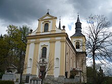
After Martin Luther's teaching had found numerous followers in Reichenau, the church was initially occupied by Protestant priests until 1668, then again by Catholic priests. The owner of the estate, Count Karl Ernest von Waldstein and Wartenberg , had the current church of St. Wenceslaus built out of stone in 1704, partly with manorial taxes and partly from church assets. In 1712 the old wooden church was demolished. Around 1830 the Wenceslas Church and the school were under the patronage of the manor.
In the 18th century textile manufacturers settled there and Johann Schöffel built a factory for cans made of hard paper. From the middle of the 19th century Reichenau formed a municipality in the judicial district of Gablonz on the Neisse . In 1856 the place received a train station on the Pardubitz – Reichenberg of the south-north German connection railway. The train crosses the Mohelka in Reichenau on a large viaduct . At the end of the 19th century the great age of the Gablonz glass jewelry shop began, from which Reichenau also benefited. Reichenau was raised to the market in 1895 and received the right to hold four annual markets.
20th century
Since 1900 a line of the Gablonzer tram led to Reichenau. In 1911 the town was raised.
After the First World War , Reichenau was added to the newly created Czechoslovakia in 1919 . The result was a factory for haberdashery goods, which was built in a moor area on the outskirts that had to be drained by a system of drainage ditches. After the city in 1938 after the Munich Agreement to the German Reich had been attached, the company was bought in 1938 by a German consortium and produced in WWII tracking devices. About 350 Jews and a hundred Ukrainians, housed in the subcamp of the Groß-Rosen concentration camp , were conscripted as workers .
After the expulsion of the majority of the German-Bohemian population and during the subsequent socialist era, the cityscape declined, and up to one hundred buildings fell victim to partial demolition. The tram connection to Jablonec was given up in 1965. After 1990, the restoration of the still preserved historical building began in places.
Expulsion of the Germans
From 1938 to 1945 Reichenau belonged to the district of Gablonz an der Neisse , district of Aussig , in the Reichsgau Sudetenland ( Czech Říšská župa Sudety ). After the end of the war, almost the entire population (mostly German Bohemia) was expropriated and expelled from Reichenau. The city was previously on the language border. The former concentration camp on the railway line served as an internment camp for the deportation of Germans from Reichenau and Gablonz . The majority of the displaced population settled in Bavaria and Baden-Württemberg .
Demographics
Until 1945 Reichenau was predominantly populated by German Bohemia, most of which were expelled.
| year | Residents | Remarks |
|---|---|---|
| 1830 | 2292 | in 352 houses |
| 1900 | 3384 | German residents |
| 1930 | 3320 | |
| 1939 | 3056 |
| year | 1970 | 1980 | 1991 | 2001 | 2003 |
|---|---|---|---|---|---|
| Residents | 1 924 | 1 967 | 1 822 | 2,013 | 2 122 |
Local division
The town of Rychnov u Jablonce nad Nisou consists of the following districts:
- Rychnov u Jablonce nad Nisou (German: Reichenau )
- Pelíkovice (German: Pelkowitz )
Settlements:
- Rydvaltice (German: Ridwalditz )
- Košovy (German: Koschen )
- Dolni Dobra Voda (German: Gutbrunn )
- Hajek
- Dolní Rychnov
- Svatý Kříž (German: Holy Cross )
- Liščí Jáma
- Zálesí
Disappeared after 1945:
- Ještřabí
- slot
Attractions
- Church of St. Wenceslas, baroque building from the years 1704–1712
- Plague column of St. Prokop, erected in 1702
- Statue of St. John of Nepomuk, erected in 1780
Honorary citizen
- 2002: Gerhard Müller (1922–2006) for his work for a reconciliation between Czechs and Germans
Web links
Individual evidence
- ↑ uir.cz
- ↑ Český statistický úřad - The population of the Czech municipalities as of January 1, 2019 (PDF; 7.4 MiB)
- ↑ Jaroslaus Schaller : Topography of the Kingdom of Bohemia . Volume 4: Bunzlauer Kreis , Prague 1786, p. 228, paragraph 68.
- ↑ a b c Johann Gottfried Sommer : The Kingdom of Bohemia . Volume 2: Bunzlauer Kreis , Prague 1834, p. 223, paragraph 78.
- ^ Rudolf M. Wlaschek: Jews in Böhmen . Munich: Oldenbourg, 1990, p. 153.
- ↑ rychnovjbc.cz
- ^ Meyer's Large Conversational Lexicon. 6th edition. Volume 16, Leipzig and Vienna 1908, p. 726, item 3.
- ^ A b Michael Rademacher: German administrative history from the unification of the empire in 1871 to the reunification in 1990. Gablonz district on the Neisse. (Online material for the dissertation, Osnabrück 2006).
- ↑ Czech population statistics
- ↑ uir.cz


