Congo (river)
| Congo | ||
|
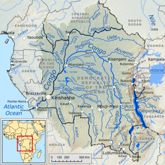
Course and catchment area of the Congo or Lualaba |
||
| Data | ||
| location |
Central Africa Democratic Republic of the Congo Angola Republic of the Congo |
|
| River system | Congo | |
| muzzle |
Atlantic coordinates: 6 ° 4 ′ 45 ″ S , 12 ° 27 ′ 0 ″ E 6 ° 4 ′ 45 ″ S , 12 ° 27 ′ 0 ″ E
|
|
| length | 4374 km with Luvua - Luapula - Chambeshi 4835 km | |
| Catchment area | 3,778,900 km² | |
| Discharge at the gauge Kinshasa (1147010) , Brazzaville A Eo : 3,475,000 km² Location: 490 km above the mouth |
NNQ (min. Month Ø) MNQ 1902–2005 MQ 1902–2005 Mq 1902–2005 MHQ 1902–2005 HHQ (max. Month Ø) |
22,351 m³ / s 32,843 m³ / s 40,250 m³ / s 11.6 l / (s km²) 57,670 m³ / s 80,832 m³ / s |
| Discharge at the mouth of the A Eo : 3,778,900 km² |
MQ 1902-2005 Mq 1902-2005 |
41,800 m³ / s 11.1 l / (s km²) |
The Congo (also Congo and Zaïre ) is a river in Africa . With a length of 4,374 km it is the second longest river in Africa; measured by its water flow of 41,800 m³ / s, it is the most water-rich river on the continent. Its catchment area is mainly in the Democratic Republic of the Congo (hereinafter called DR Congo ), where the river flows through the vast Congo Basin .
River course
The Congo rises as Lualaba in the south of the DR Congo in the Katanga region in the southern foothills of the Mitumba Mountains . There its source is about 100 kilometers west of Lubumbashi . The Lualaba first flows north, past the Upemba and Kisalesee lakes and about 150 kilometers further north, it absorbs the water of the Luvua - Luapula - Chambeshi river coming from the east , which as a tributary is significantly longer than the Lualaba up to this point. The Congo has a length of 4835 kilometers with the Luvua – Luapula –Chambeshi river . Around this river mouth it enters the large Congo Basin . Another 150 kilometers further north, the Lukuga, coming from the east, flows towards it. From there the Lualaba flows further north to the Boyoma Falls near Kisangani .
From there on it bears the name Congo - flowing in a westerly direction . Where it turns to the southwest, it flows through an extensive swamp landscape near Mbandaka . The Ubangi , its second largest tributary, flows into it. From there on, it forms the natural border between the Democratic Republic of the Congo and the Republic of the Congo . A little further south the Kwa-Kasai flows in , its largest tributary by far. He then reaches the Malebo , Brazzaville and Kinshasa pools ; the river is navigable above these cities.

A little later, at the exit of the Congo Basin, in the course of the breakthrough valley through the Lower Guinea Sill in the 350-kilometer-long rapids of the Livingstone Falls, it overcomes a gradient of 274 meters. At Mbanza , the Congo leaves the common state border, crosses the westernmost tip of the DR Congo , which is only about 100 to 150 kilometers wide, and reaches the city of Matadi before the border with Angola . On this border, the river - now called Rio Zaire - flows around 135 kilometers further west, only to flow into the Atlantic Ocean in a funnel up to 40 kilometers wide at the border in the Zaire lowlands , where the Congo Channel still meets 150 kilometers below the surface of the sea.
Catchment area
The catchment area of the Congo is between 3,789,000 and 3,778,900 km², depending on the source, the second largest in the world after that of the Amazon and is mainly located in the DR Congo. In addition, it is divided into areas in the Central African Republic , Angola , the Republic of the Congo , Tanzania , Zambia , Cameroon and even partly in Burundi and Rwanda . There are still areas in Gabon which, however, are mathematically negligible.
| country | Area [km²] | Percent catchment area | Percent land area |
|---|---|---|---|
| Zambia | 177.735 | 4.7 | 23.6 |
| Tanzania | 244,593 | 6.5 | 25.9 |
| Burundi | 14,574 | 0.4 | 52.4 |
| Rwanda | 6,464 | 0.2 | 24.5 |
| Central African Republic | 403,570 | 10.7 | 64.8 |
| Cameroon | 96,395 | 2.5 | 20.3 |
| Republic of the Congo | 246,977 | 6.5 | 72.2 |
| Angola | 285,395 | 7.5 | 22.9 |
| DR Congo | 2,313,350 | 61.1 | 98.7 |
| Congo as a whole | 3,789,053 | 100.0 |
Length, navigability and depth
The Congo is 4,374 kilometers long, of which about 3,000 kilometers are navigable. It is an important shipping route ; the sometimes long non-navigable sections are bypassed by railway lines . In 2008/2009 a team of biologists measured water depths of up to 220 meters in the lower reaches using an echo sounder , making the Congo the deepest river on earth.
Abundance of water, rapids and waterfalls
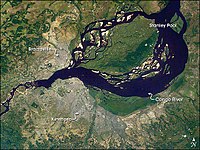
The Congo has the most water-rich rapids on earth, of which the Stanley and Livingstone Falls are the best known. At its mouth it discharges between 23,000 and 75,000 m³ / s of water - an annual average of 41,800 m³ / s. The brownish water color at the confluence with the Atlantic can be seen in parts 20 to 30 kilometers from the coast.
Hydrometry
The flow rate of the Congo was measured over 80 years (1903–83) in Kinshasa about 490 kilometers upstream from the mouth (in m³ / s).

exploration
The Portuguese navigator Diogo Cão was the first European to come to the Congo in 1482 and sailed it upstream. British African explorer Sir Henry Morton Stanley explored its course inland when he sailed the river from 1876 to 1877 and explored the country.
For more information, see the main article on the history of discovery in Africa .
places
Tributaries
In the following table tributaries of the Congo are listed downstream and the cardinal points from which they come are noted.
Upper course
to the beginning of the Congo left bend (to Kisangani ):
- left , from the southwest: Lubudi
- right , from the southeast: Lufira , Luvua , Luapula
- right , from the east: Lukuga , Luama , Elila , Ulindi , Lowa , Maiko
Middle course
from the beginning of the Congo left bend (from Kisangani to Mbandaka ):
- right , from the northeast: Lindi
- left , from the south: Lomami
- right , from the northeast: Aruwimi , Itimbiri
- right , from the north: Mongala
- left , from the east: Lulonga - Maringa , Ruki - Busira
At the end of the Congo left-hand bend (to Brazzaville / Kinshasa ):
Lower course
After the end of the Congo left bend (from Brazzaville / Kinshasa ):
Dams
With the Inga dams , part of the hydropower in the area of the Livingstone Falls is used. There are plans to expand these facilities to the world's largest hydropower plant . With an output of around 40 GW, around 320 TWh of electrical energy will be produced annually after completion of the project , which would increase Africa's energy production by around a third. May 2013 the start of construction for 2015 between the Democratic Republic of the Congo and South Africa was decided.
See also
literature
Tim Butcher : Blood River. Into the dark heart of the Congo. National Geographic paperback, Frederking & Thaler, Munich 2008, ISBN 3-89405-862-5 .
Web links
Individual evidence
- ↑ Monthly values for the Kinshasa and Brazzaville gauges , accessed on November 12, 2015. The values for the Kinshasa gauge end 1983; after that, the values of the almost exactly opposite level Brazzaville take their place , whose values, which are simultaneous with Kinshasa , have a stable correlation with a factor of 0.98 over 50 years.
- ↑ a b GRDC - Kinshasa gauge
- ↑ A. Shiklomanov, John C. Rodda: World Water Resources at the Beginning of the Twenty-First Century . Cambridge 2003
- ^ FAO - The Congo / Zaire River basin
- ↑ US Geological Survey: Discharge and Other Hydraulic Measurements for Characterizing the Hydraulics of Lower Congo River (PDF; 829 kB)
- ↑ Evolution on Steroids: Bizarre Fish of the Congo Featured in New Video ( Memento of the original from December 11, 2011 in the Internet Archive ) Info: The archive link was inserted automatically and has not yet been checked. Please check the original and archive link according to the instructions and then remove this notice. , American Museum of Natural History , accessed January 17, 2010
- ↑ The world's largest hydropower plant is to be built on the Congo , ORF.at May 19, 2013
- ↑ Megaproject in the middle of Africa. Congo plans gigantic hydropower plant . In: n-tv.de , May 20, 2013. Retrieved May 21, 2013.

