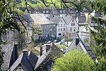
Kornelimünster / Walheim
|
Kornelimünster / Walheim
City of Aachen
Coordinates: 50 ° 43 ′ 17 ″ N , 6 ° 10 ′ 49 ″ E
|
|
|---|---|
| Height : | approx. 240 m |
| Area : | 37.03 km² |
| Residents : | 15,673 (2013) |
| Population density : | 423 inhabitants / km² |
| Postal code : | 52076 |
| Area code : | 02408 |
|
Location of Kornelimünster / Walheim in Aachen
|
|
Kornelimünster / Walheim is one of the seven Aachen city districts . It is the southernmost district of the city of Aachen and lies on the border with Belgium and the Eifel . The landscape is called Münsterländchen .
history
The municipality of Kornelimünster / Walheim was created when, as part of the regional reform in North Rhine-Westphalia, seven surrounding municipalities were incorporated into Aachen in accordance with the Aachen Act on January 1, 1972 , including the previously independent municipalities of Kornelimünster and Walheim . While the Walheim community as a whole was incorporated into Aachen, parts of the Kornelimünster community, including the villages of Breinig and Venwegen , were incorporated into the city of Stolberg . Walheim and the parts of Kornelimünster incorporated into Aachen have since formed two of the districts of Aachen and were combined with the districts of Lichtenbusch and Sief , which had previously belonged to Aachen, to form the new Kornelimünster / Walheim district.
Associated places
- Calibration
- Friesenrath , on the border with the Eifel community Roetgen
- Hahn , on the Inde
- Kornelimünster , administrative center, with a historic town center
- Lichtenbusch , German-Belgian border town with motorway border crossing on the A44 / E40
- Nütheim
- Oberforstbach , with industrial area Pascalstraße (primarily IT industry )
- Schleckheim
- Schmithof
- Sief , with border crossing to Raeren ( Belgium )
- Walheim , trade center and largest town in the borough
Twin town
Since 1960 there has been a partnership between the municipality of Walheim and Montebourg ( Normandy / France ), which is maintained after the incorporation in 1972 by the Aachen district of Kornelimünster / Walheim. This makes it the oldest of Aachen's city partnerships . On the French side, the town twinning is maintained by the Association d'Échanges Culturels et Sportifs Comité de Jumelage MONTEBOURG-WALHEIM and on the German side by the Jumelage Komitee Aachen-Walheim-Montebourg eV
Sights / excursion destinations
- historic center of Kornelimünster with half-timbered buildings on the Inde .
- former Reichsabbey Kornelimünster from 1721 , seat of the North Rhine-Westphalian state institution Kunsthaus Nordrhein-Westfalen Kornelimünster (until 2015 art from North Rhine-Westphalia), public exhibition of funding purchases by North Rhine-Westphalian artists. For opening times, see web links.
- Kornelimünster abbey garden
- Provost church Kornelimünster (originally from 814–817 AD)
- Varnenum - Gallo - Roman excavation site near Kornelimünster (towards Breinig) with the remains of a Roman temple complex .
- Former quarries and lime kilns of the Walheim / Kornelimünster lime kiln plants (signposted Kalkofenweg with explanatory boards).
- Leisure area in the former quarry in Walheim with a large playground, mini golf, barbecue area, etc. (since summer 2005 also accessible via the Vennbahn cycle path ).
- Listed cemetery church St. Stephanus in Kornelimünster
- Listed chapel of St. Bernhard in Friesenrath
- Listed Trinity Chapel in Schleckheim
- Listed chapel Maria im Schnee in Kornelimünster
- Scenic particularly attractive valleys on Inde, Iterbach and Rollefbach
- Vennbahntrasse (cycle path)
- Beginning / end of the Eifelsteig to Trier
Individual evidence
- ↑ Population. Retrieved February 23, 2014 .
- ^ Federal Statistical Office (ed.): Historical municipality directory for the Federal Republic of Germany. Name, border and key number changes in municipalities, counties and administrative districts from May 27, 1970 to December 31, 1982 . W. Kohlhammer, Stuttgart / Mainz 1983, ISBN 3-17-003263-1 , p. 305 .
- ^ Jumelage committee Aachen-Walheim-Montebourg eV


