Krauthausen (Sontra)
|
Krauthausen
City of Sontra
Coordinates: 51 ° 5 ′ 17 ″ N , 9 ° 58 ′ 39 ″ E
|
|
|---|---|
| Height : | 221 (218-254) m above sea level NHN |
| Area : | 4.33 km² |
| Residents : | 128 (Feb 3, 2020) |
| Population density : | 30 inhabitants / km² |
| Incorporation : | December 31, 1971 |
| Postal code : | 36205 |
| Area code : | 05653 |
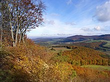
Krauthausen is a district of Sontra in the Werra-Meißner district in northern Hesse .
Geographical location

Krauthausen lies between the Ringgau in the east and the Richelsdorf mountains in the south, around 3.5 km (as the crow flies ) northeast of Sontra . It is traversed by the Ulfe , a south-southeast tributary of the Sontra . The federal highway 400 runs through the village . Near the place was Eckhardshausen that already in the Middle Ages to the deserted village was.
To the east of the village in the direction of Schickenberg along the boundary to the Ringgau lies the two-part nature conservation and FFH area “ Boyneburg and Schickeberg bei Breitau ”.
history
The place is first mentioned in 1141 as Crutthusun . Like many surrounding towns, Krauthausen was also sacked during the Thirty Years' War .
In 1960 Krauthausen was the district winner in the competition Our village should be more beautiful .
As part of the regional reform in Hesse , Krauthausen was incorporated into Sontra on December 31, 1971.
religion
The church was built in the 12th century. A church may have already existed at the time of the Carolingians . The vaulted arch of the apse rests on the right and left on a capital , the right of which is provided with a Romanesque checkerboard pattern.
Infrastructure
- In Krauthausen there is a village community center with a room for the youth.
Web links
- District Krauthausen In: Website of the city of Sontra.
- Krauthausen, Werra-Meißner district. Historical local dictionary for Hessen. In: Landesgeschichtliches Informationssystem Hessen (LAGIS).
- Literature on Krauthausen in the Hessian Bibliography
Individual evidence
- ↑ a b Krauthausen In: 0 Website of the city of Sontra. Accessed in July 2020.
