
Big creams
| Big creams | ||
 |
||
| Data | ||
| location | Waldviertel , Austria | |
| River system | Danube | |
| Drain over | Kamp → Danube → Black Sea | |
| source | Kl. Krems near Scheib, Kirchschlag community , Gr. Krems near Bad Traunstein in the Weinsberg Forest 48 ° 23 ′ 56 ″ N , 15 ° 6 ′ 46 ″ E |
|
| Source height | 950 m above sea level A. | |
| muzzle |
Kamp near the Altenwörth power station Coordinates: 48 ° 22 '20 " N , 15 ° 51' 51" E 48 ° 22 '20 " N , 15 ° 51' 51" E |
|
| Mouth height | 180 m above sea level A. | |
| Height difference | 770 m | |
| Bottom slope | 9.5 ‰ | |
| length | 81 km | |
| Catchment area | 365.7 km² | |
| Medium-sized cities | Krems | |
| Small towns | Gföhl , Traismauer | |
| Communities | Bad Traunstein , Ottenschlag , Sallingberg , Kottes-Purk , Lichtenau , Albrechtsberg , Weinzierl , Senftenberg , Gedersdorf (Theiß) , Grafenwörth , Kirchberg ( Altenwörth ) | |
The Krems is a river in the southern Waldviertel ( Lower Austria ) whose longest source river, the Große Krems, can also be used to describe the entire river.
Upper course
The Große Krems rises south of Bad Traunstein , more precisely west of Reitzendorf (Vordere Waldhäuser) at an altitude of 950 m and drains the eastern Weinsberger Wald and flows through the Weyerteich (near Ottenschlag ) with the imposing railway bridge over the Kremstal. The Kleine Krems rises between Roggenreith and Höllerbrand . The two rivers flow through the rough granite landscape in an easterly direction. More important places are Großreinprechts on the Große Krems and Kottes on the Kleine Krems.
Middle course
Before the confluence of the two source rivers, they cut deep into the Bohemian Massif and form an imposing valley landscape. The union takes place just below Hartenstein Castle , where the Gudenus Cave , which was washed out of the shore and was inhabited in the Stone Age, is also located.
Lower course
Before Senftenberg, the Krems forms the backbone of the Kremstal wine-growing region and emerges from the granite and gneiss highlands near Krems on the Danube , where it flows into the Danube in the area of the Krems harbor . In the course of the construction of the Altenwörth power station on the Danube , the estuary was relocated to Altenwörth together with that of the Kamp .
photos

Bad Traunstein , not far from here, the source of the Große Krems

Hartenstein Castle , including the Kleine Krems

Senftenberg castle ruins in the Kremstal

View from the Imbach ruins, near the city of Krems

The Krems River in the area of the Mühlhof settlement in Krems

The river in the Krems urban area, before renaturation
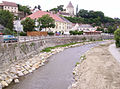
The Krems river during restoration work

Donaukraftwerke Altenwörth , here the Krems flows into the Danube


_02.jpg)


See also
This river is not to be confused with the Upper Austrian river Krems , which flows into the Traun .
Web links
Remarks
- ↑ BMLFUW (Hrsg.): Area directory of the river areas: Danube area from the Enns to the Leitha. In: Contributions to Austria's Hydrography Issue 62, Vienna 2014, p. 94. PDF download , accessed on July 8, 2018.
- ↑ Four incorporated cadastral communities in the city are located a few kilometers from the town center, in the Kremstal.
- ↑ The Krems River flows through an alluvial forest area north of the Danube belonging to the municipality, which was separated from the urban area south of the Danube by the Danube regulation in the 19th century.