Kuhsee (Augsburg)
| Cow lake | ||
|---|---|---|

|
||
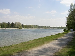
| The Kuhsee seen from the north bank. | ||
| Geographical location | Augsburg-Hochzoll-Süd , Swabia District , Bavaria | |
| Tributaries | Groundwater | |
| Drain | Lech | |
| Places on the shore | augsburg | |
| Data | ||
| Coordinates | 48 ° 20 '20 " N , 10 ° 56' 23" E | |
|
|
||
| surface | approx. 17 hectares of water approx. 25 hectares of land approx. 42 hectares total area |
|
| length | approx. 1100 m | |
| width | approx. 230 m | |
| Maximum depth | approx. 5 m | |
|
particularities |
not a lake, but an oxbow arm of a river, artificially created |
|
The Kuhsee is an artificially created lake in the Augsburg district of Hochzoll . The name Kuhsee arose because the of the erstwhile Lech connected Backwater urban herds were led to impregnate. The backwater of the Lech was already popularly known as the Kuhsee.
history
The first plans to convert the Kuhsee into a bathing lake as part of a job creation measure by the unemployed existed as early as 1930. This plan failed because of concerns about the number of visitors to the municipal public swimming pools , which were subject to a fee , had to drop . Local residents also feared that the newly created enlarged water area could lead to a mosquito plague .
In 1967 the city of Augsburg prepared plans for better flood protection in Hochzoll and also for the drinking water protection area west of the Lech. After the last major flood on August 10, 1970, when the Lech banked eastwards and caused destruction in Augsburg-Hochzoll, the city council decided to build a flood protection dam on the east and west sides of the Lech . The Kuhsee was created by extracting gravel from the oxbow arm of the Lech, which was dammed in the south-east at the Hochablass .
The Kuhsee does not have a direct inflow, the indirect inflow consists of the groundwater flow , which extends in a south-north direction. In the north of the lake, a weir is integrated into the east side of the Hochablass , with which the water level can be lowered by one meter.
Today's artificial lake basin is around 17 hectares and 1–5 meters deep. It serves as an attractive bathing water in summer and has been a. equipped with lawns and playgrounds , but is also used all year round as a local recreation area.
Landscape protection area
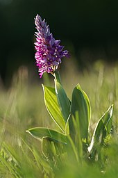
The Kuhsee and the eastern bank of the Lech have been under landscape protection since 1951 (VO according to BayNatSchG 1973/1987 of September 3, 1951 / December 6, 1977). A stone's throw from the Kuhsee to the south, you come across the Kuhseeheide , a typical habitat for the Lech region. The dry grassland is part of the Lechtalheiden and is under nature protection due to its threatened flora and fauna . Rare plants such as gentians and orchids can be found on the calcareous soils .
leisure
In summer, around 10,000 bathers populate the shores of the lake on a sunny weekend. During the bathing season, the water watch station is manned on weekends . You can grill in the zones on the southern shore of the lake.
In winter around 1,000 visitors come to the lake every day. On the frozen lake, if the ice is thick enough , you can go ice skating or curling .
Others
Today's restaurant on the east bank was built as a replacement for the large high drainage restaurant on the west side of the Lech, demolished in 1978 in the new drinking water protection area. The location of the old beer garden with its chestnut trees can still be seen clearly.
Rowing boat rentals have existed since the 1950s . At that time one could still row through the reed- covered oxbow lakes to a peninsula, which today forms the west bank.
In terms of fishing law and legal , the Kuhsee, which is still an oxbow lake, is a tributary of the Lech and therefore not a lake . This circumstance resulted from the centuries-old law of the Augsburg city fishermen, which certifies that everything that the Lech gives and takes belongs to them .
Auensee , Weitmannsee , Ilsesee and Mandichosee are located south of the Kuhsee (along the Lech) and can be easily reached by bike.
Infrastructure
The Kuhsee is ideally developed for local recreation. The following facilities are available:
- Two parking spaces: Augsburg-Hochzoll northern and southern parking lot
- Two kiosks
- A restaurant
- Five toilet facilities
- Fitness course 2006
- Ping pong tables
- Two playgrounds
- Barbecue facilities on the south bank
- Boat rental at the restaurant
- Wasserwacht Kuhsee (always manned on weekends when the weather is nice)
- Bus stop "Hochzoll / Kuhsee" for lines 29/30
Events
- Kuhsee Festival
- Kuhsee Triathlon
See also
literature
- Non-fiction
- Wolfgang Poschwatta: Kuhsee near Augsburg . In: Hans Frei (Ed.): In flight over Swabia. A geography with 80 colored aerial photographs . Published on behalf of the Swabian district (= contributions to regional studies of Swabia . Volume 1 ). 2nd, improved edition. Konrad, Weissenhorn 1977, ISBN 3-87437-145-X , p. 226 .
- City of Augsburg: The Lech. Change in a wild river landscape (= Augsburger Ökologische Schriften . Issue 2). City of Augsburg, 1991, ISSN 0941-2123 .
- Wolfgang Kučera u. a. (Ed.): Augsburg on foot. 16 city tours through history and the present . VSA-Verlag, Hamburg 1993, ISBN 3-87975-628-7 , p. 143 .
- Franz Häussler: Augsburg album. Photos from yesteryear . 4th, unchanged edition. Wißner, Augsburg 1998, ISBN 3-89639-109-7 , pp. 136 ff .
- Eberhard Pfeuffer: The Lech . Wißner, Augsburg 2010, ISBN 978-3-89639-768-3 , pp. 152 ff .
- Fiction
- Peter Garski : The Kuhsee disaster. Klaus Kessler and Helle are investigating again . TTBC, Augsburg 2009, ISBN 978-3-941183-08-7 .
Web links
Individual evidence
- ^ Hans Frei, Günther Grünsteudel : Augsburger Stadtlexikon - The city history of Augsburg: Kuhsee. In: stadtlexikon-augsburg.de. Retrieved on August 25, 2017 (as of 1998).


