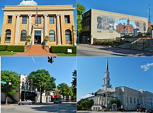
LaGrange (Georgia)
| LaGrange | |
|---|---|
 LaGrange |
|
| County and state location | |
| Basic data | |
| Foundation : | 1828 |
| State : | United States |
| State : | Georgia |
| County : | Troup County |
| Coordinates : | 33 ° 2 ′ N , 85 ° 2 ′ W |
| Time zone : | Eastern ( UTC − 5 / −4 ) |
| Residents : | 29,588 (as of 2010) |
| Population density : | 394.5 inhabitants per km 2 |
| Area : | 76.5 km 2 (approx. 30 mi 2 ) of which 75.0 km 2 (approx. 29 mi 2 ) are land |
| Height : | 238 m |
| Postcodes : | 30240, 30241, 30261 |
| Area code : | +1 706 |
| FIPS : | 13-44340 |
| GNIS ID : | 0316522 |
| Website : | www.lagrange-ga.org |
| Mayor : | Jim Thornton |
LaGrange is a city and also the county seat of Troup County in the US state of Georgia with 29,588 inhabitants (as of 2010).
geography
LaGrange is located in the very west of the state and about 90 km southwest of Atlanta . The urban area extends in the north to the Chattahoochee River , which is artificially dammed here to form West Point Lake .
history
LaGrange was named a city in December 1828. In May 1854, the Atlanta & West Point Railroad opened a rail line from Atlanta via LaGrange to West Point . In January 1891, the Macon & Birmingham Railroad completed a line from Macon to LaGrange and the Atlanta, Birmingham & Atlantic Railroad reached LaGrange in January 1907.
Demographic data
According to the 2010 census, the then 29,588 inhabitants were distributed over 11,243 inhabited households, which gives an average of 2.52 people per household. There are a total of 12,846 households.
64.6% of households were family households (consisting of married couples with or without offspring or one parent with offspring) with an average size of 3.13 people. There were children under the age of 18 in 37.7% of all households and persons aged 65 and over in 24.1% of all households.
31.1% of the population were younger than 20 years, 27.6% were 20 to 39 years old, 24.1% were 40 to 59 years old, and 17.3% were at least 60 years old. The mean age was 33 years. 46.2% of the population were male and 53.8% were female.
44.5% of the population identified themselves as whites , 48.0% as African American , 0.2% as Indians and 2.5% as Asian Americans . 2.9% said they belonged to another ethnic group and 1.8% to several ethnic groups. 4.7% of the population was made up of Hispanics or Latinos .
The average annual income per household was 33,501 USD , while 29.4% of the population lived below the poverty line.
Town twinning
LaGrange has twinned cities with
Attractions

The following properties are listed on the National Register of Historic Places :
economy
Automobile manufacturer Kia Motors Manufacturing Georgia is headquartered in LaGrange.
traffic
LaGrange is crossed by Interstates 85 and 185 , US Highways 27 and 29, and Georgia State Routes 109 and 219 . The local airfield LaGrange Callaway Airport borders directly on the city area in the southwest. The nearest international airport is Columbus Airport (around 60 km south).
crime
The crime rate was 425 points in 2010 (US average: 266 points) in the average range. There were six rapes, 60 robberies, 66 assaults, 376 break-ins, 1234 thefts and 76 car thefts.
sons and daughters of the town
- James M. Griggs (1861-1910), politician
- Ulrich Bonnell Phillips (1877–1934), historian
- Howard H. Callaway (1927–2014), businessman and politician
- Bubba Sparxxx (* 1977), rapper
- Brian West (born 1978), football player
- Elijah Kelley (* 1986), actor, singer and dancer
- Wesley Woodyard (born 1986), American football player
Web links
- Website of the city (Engl.)
Individual evidence
- ↑ LaGrange Depots. Retrieved March 9, 2018 .
- ^ Profile of General Population and Housing Characteristics: 2010 . United States Census Bureau . Retrieved March 9, 2018.
- ^ LaGrange's Sister City Program. Retrieved March 9, 2018 .
- ↑ GEORGIA - Troup County. National Register of Historic Places , accessed March 9, 2018 .
- ↑ http://www.city-data.com/crime/crime-LaGrange-Georgia.html
