
Liesing (Schwechat)
| Liesing | ||
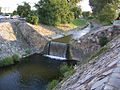
 The Liesing in the 23rd district when the water level is high |
||
| Data | ||
| location | Lower Austria , Vienna | |
| River system | Danube | |
| Drain over | Schwechat → Danube → Black Sea | |
| source | Confluence of Reicher Liesing and Dürrer Liesing 48 ° 8 ′ 15 ″ N , 16 ° 15 ′ 47 ″ E |
|
| Source height | 520 m above sea level A. | |
| muzzle | At the city of Schwechat in the Schwechat coordinates: 48 ° 8 ′ 9 ″ N , 16 ° 28 ′ 11 ″ E 48 ° 8 ′ 9 ″ N , 16 ° 28 ′ 11 ″ E |
|
| Mouth height | 158 m above sea level A. | |
| Height difference | 362 m | |
| Bottom slope | 12 ‰ | |
| length | 30 km | |
| Catchment area | 117.4 km² | |
| Big cities | Vienna | |
| Small towns | Schwechat | |
The Liesing , even Liesingbach , a 30-km-long river , originates in Lower Austria Vienna Woods , then flows through the city of Vienna , where the creek 23 Viennese district Liesing is his name, and opens again in Lower Austria in Schwechat in Schwechat .
Surname
Its name is derived from the Slavic Lesnica or Lesnička and means forest stream .
course
The Liesing arises from the confluence of the Dürren Liesing and the Reichen Liesing, whose springs are located at around 520 m above sea level in the Vienna Woods. They flow through different rock zones , the special properties of which have given the source rivers different names.
The right drought, Liesing, has its source near Kaltenleutgebens and flows through the limestone area of the Vienna Woods . It shows the typical characteristics of a karst brook , because it seeps into the karst rock , which means that the brook can dry up in dry periods. The left Reiche Liesing rises in Breitenfurt and flows through the flysch zone of the Vienna Woods. This rock is not very permeable to water, so that the water swells quickly when there is large amounts of precipitation .

The confluence of the two source rivers and the entry into the Vienna Basin finally take place at Rodaun . Here the Liesingtal expands and is increasingly used for viticulture . Liesing Castle is located further east in this area . Its moat and the associated drainage over the Ketzergasse area is taken as an indication that there was a water connection between the Liesingbach and the Petersbach valley. It is believed that this connection was created artificially. Since the course of the Liesingbach in Liesing makes a clear swivel to the north, but the Mühlbach makes to the south (today's Färbermühlgasse), it cannot be ruled out that the Liesing used to flow further east (before it was relocated ) and this old course of the Liesingbaches the fortification of the Liesing moated castle and then (via the moat drawn on old maps, which was also called Aubach) fed the course of today's Petersbach.

Further to the east, due to the less resistant rock, the Liesingtal widens even further and forms a valley floor up to 500 m wide. The Liesing itself, however, shows a slightly meandering course . In southern Vienna, the Liesing formed large deposits of Tegel , which were mainly used for brick production in the 19th century. South of the Laaer Berg , the Liesing leaves Vienna after around 20 km at Kledering and shortly afterwards flows into the Schwechat River at Schwechat.
Buildings and renaturation
The constant danger of flooding from the Liesing increased, especially in the 19th century due to industrialization . The water quality also decreased considerably due to bank construction, narrowing of the stream bed and the admission of sewage , so that around 1930 it was decided to regulate the Liesing, but work could not begin until 1947. In 1969 the hard construction was completed. It is documented in over a thousand photos that are in the photo collection of the Vienna City and State Archives, but some have also been published. Today efforts are being made to replace the hard construction with renaturation. Since 2001 massive demolitions have been taking place along the entire course of the Liesing, which were completed in 2006 in the upper area near Rodaun and in the lower part near Oberlaa and Rothneusiedl . In the middle area, as in Erlaa and Inzersdorf , the river has not yet been dismantled.
qualities
The water quality has also been improved, as the Blumental sewage treatment plant no longer uses the Liesing as a receiving water . The wastewater is now fed directly to the main sewage treatment plant in Simmering . By using the Liesingbach collection canal, which is prepared to store excess water, no more untreated water will overflow into the Liesing even in heavy rain. In the tanks of the former Blumental sewage treatment plant, a total of 20 million liters of storage capacity can be filled at 3,000 liters per second.
Today the Liesing is mainly used as a recreation area in Vienna. There are usually no roads on either side of the banks, but bike and footpaths.
photos
- At normal water level
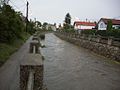
Very strongly regulated Liesing in the Atzgersdorf area (gravel basin)

Heavily regulated Liesingbach in the Liesing area

Confluence of Reicher and Dürrer Liesing in Rodaun


Drought Liesing just before the confluence

Renatured Liesingbach in the Kalksburg area, Rodaun


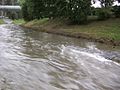
- After heavy rain in July 2005, from the stream to the raging river.
Between Steinsee and Schloßsee in Inzersdorf
Before the underpass Altmannsdorfer Straße
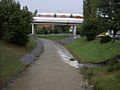
Underground line U6 crosses Liesing near Alterlaa


Web links
- The Liesing on the website of the City of Vienna (accessed June 11, 2010)
- Entry on Liesing (Schwechat) in the Austria Forum (in the AEIOU Austria Lexicon ) (accessed on June 11, 2010)
Individual evidence
- ↑ BMLFUW (Hrsg.): Area directory of the river areas: Danube area from the Enns to the Leitha. In: Contributions to Austria's Hydrography Issue 62, Vienna 2014, p. 118. PDF download , accessed on July 8, 2018.
- ^ Ferdinand Opll: Maps as a source of topographical knowledge. The Liesinger area in the south of Vienna at the time of Maria Theresa. In: Viennese history sheets . Edited by the Association for the History of the City of Vienna . 68th year. Issue 2/2013. ISSN 0043-5317 ZDB -ID 2245-7 . P. 118.
- ↑ Margit Altfahrt: A fight against the forces of nature. The regulation of the Liesingbach in the mirror of the Gerlach photo archive. In: Karl Fischer (Ed.): Studies on Viennese history. Yearbook of the Association for the History of the City of Vienna - JbVGStW. Volume 66. Association for the History of the City of Vienna. Vienna 2010. ISSN 1027-8788 . Pages 13-36.
- ↑ Canal plan (Liesingbach canals at the bottom). Retrieved April 18, 2015.
- ↑ Blumental reservoir for 3000 liters per second (accessed April 18, 2015.).