
Breitenfurt near Vienna
|
market community Breitenfurt near Vienna
|
||
|---|---|---|
| coat of arms | Austria map | |
 |
|
|
| Basic data | ||
| Country: | Austria | |
| State : | Lower Austria | |
| Political District : | Mödling | |
| License plate : | MD | |
| Surface: | 27.07 km² | |
| Coordinates : | 48 ° 8 ' N , 16 ° 9' E | |
| Height : | 295 m above sea level A. | |
| Residents : | 5,894 (Jan 1, 2020) | |
| Population density : | 218 inhabitants per km² | |
| Postal code : | 2384 | |
| Area code : | 02239 | |
| Community code : | 3 17 03 | |
| NUTS region | AT127 | |
| UN / LOCODE | AT BFW | |
| Address of the municipal administration: |
Hirschentanzstrasse 3 2384 Breitenfurt near Vienna |
|
| Website: | ||
| politics | ||
| Mayor : | Wolfgang Schredl ( ÖVP ) | |
|
Municipal Council : ( 2020 ) (29 members) |
||
| Location of Breitenfurt near Vienna in the Mödling district | ||
  |
||
 Office building market community Breitenfurt |
||
| Source: Municipal data from Statistics Austria | ||

Breitenfurt near Vienna is a market town with 5894 inhabitants (as of January 1, 2020) southwest of Vienna in the Mödling district in Lower Austria .
geography


Breitenfurt is located directly on the border of the city of Vienna, in the Vienna Woods in the Valley of the Rich Liesing and includes its source area. Geologically, it is located on the southern edge of the Laaber Platte in the flysch zone and borders the Kaltenleutgebens limestone massif . In terms of area, the municipality is one of the largest in the district and therefore only has a population density of 197 / km². The place has great differences in altitude and is between 260 and 592 meters above sea level.
The district of Breitenfurt-Ost, in particular, represents an “in-between town” in terms of urban geography, which cannot be described as either urban or rural. It is spatially in the transition area from the urban space of the city of Vienna to the rural area and is also in a process of transformation over time. The district is characterized by urban features such as high population density and compact development, but also characterized by generous greenery, numerous leisure areas and a strong relationship to the landscape.
Community structure
Politically, the community is divided into the two cadastral communities of Breitenfurt and Hochroterd. Structurally, the community is divided into three parts with Breitenfurt-Ostend directly bordering Vienna- Kalksburg , Breitenfurt-Ost and Breitenfurt-West, from where you can get to Wolfsgraben via the Kleiner Semmering .
Breitenfurt is a scattered settlement that consisted of 12 isolated individual settlements after the Second World War. Lt. Before 2001, in addition to the main town of Breitenfurt-Ost, there were the Rotten Großhöniggraben , Hochroterd , Linker Graben and Rechter Graben, the settlements of Hirschentanz , Breitenfurt-West, Eigenheimsiedlung, Kleiner Semmering and Ostend as well as several individual homesteads. In 2001 the community consisted of just one village of the same name.
In the settlement morphological mapping from 2018, in which the settlement area was classified due to its structural, traffic and open space planning structure, the community shows the following districts: Breitenfurt East, Breitenfurt West, Eigenheim, Gernbergstraße, Großhöniggraben, Hammerlwiese, Hirschentanz, Hochroterd, Kleiner Semmering, Königsbühel, Linker Graben, Ostend, Pölleritzerwiese, Rechter Graben and Sperrberg.
Neighboring communities
In addition to the state border with Vienna, a district border runs between the districts of Mödling and St. Pölten on the north-western boundary of the municipality of Wolfsgraben. In addition, Breitenfurt has shared municipal boundaries with the municipalities of Laab im Walde, Wienerwald and Kaltenleutbaren within the Mödling district.
| Wolf pit | Laab in the forest | |
.svg)
|
Vienna | |
| Vienna Woods | Give cold people |
history
Breitenfurt was founded relatively late and appears in documents for the first time in 1622 as a populated area, while until then Breitenfurt was only in use as a field name. Up until the Turks' storm in 1683 there was an imperial hunting lodge in what is now the municipality, which as a ruin still adorns the town's coat of arms. After the Turkish siege, there were still 20 houses in Breitenfurt. However, the area was soon populated with settlers from Salzburg, Bavaria and Styria. The residents were mainly woodworkers who lived in 42 houses in 1721. Another 32 houses were in other parts of today's community. In the years from 1714 to 1732 the accountant and Ministerial Banko Deputation Gregor Wilhelm von Kirchner had a baroque castle built in the village, which was almost completely demolished in 1796 and of which only the parish church (former castle chapel) remains today.
In 1848 Breitenfurt became an independent municipality and in 1850 elected the first mayor. As a result, the place developed into a popular destination for the nearby urban population of Vienna, so that u. a. the hospitality industry flourished. In connection with this, among other things, there was a plan in 1898 to build an electric railway from Liesing via Kalksburg to Breitenfurt. After the initial enthusiasm of affected or interested communities, the further question of costs in particular may have thwarted the project.

With the growing population around the turn of the century, more and more businesses opened shops in the village, which was finally granted market rights in 1930 . Until 1938, Breitenfurt belonged to the Hietzing-Umgebung district before, after the National Socialists came to power, the place was incorporated into the city of Vienna like many other places in Lower Austria and became part of the 25th district of Greater Vienna . It was not until 1954 that Breitenfurt became independent again and fell back to Lower Austria, where it was assigned to the Mödling district .
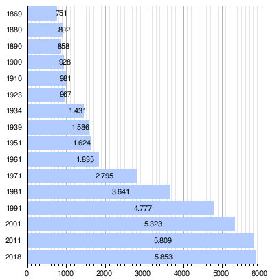
Population development
Since the beginning of the population surveys, the number of inhabitants has increased faster than the national population. After increases of over 30% in the periods 1971–1981 and 1981–1991, an increase of 11.4% was recorded in the period 1991–2001.
Religions
According to the 2001 census data , 65.7% of the population are Roman Catholic and 5.3% Protestant . 1.1% are Muslims , 0.9% belong to Orthodox churches . 21.8% of the population have no religious denomination.
politics
The municipal council has had 29 members since 2005.
- With the municipal council elections in Lower Austria in 2000, the municipal council had the following distribution with 25 seats: 14 ÖVP, 7 SPÖ, 2 FPÖ, and 2 Greens.
- With the municipal council elections in Lower Austria in 2005, the municipal council had the following distribution with 29 seats: 15 ÖVP, 11 SPÖ, and 3 Greens.
- With the municipal elections in Lower Austria in 2010 , the municipal council had the following distribution with 29 seats: 15 ÖVP, 8 SPÖ, 4 Greens, and 2 FPÖ.
- With the municipal elections in Lower Austria in 2015 , the municipal council had the following distribution with 29 seats: 11 ÖVP, 9 Greens, 8 SPÖ, and 1 FPÖ.
- With the municipal council elections in Lower Austria 2020 , the municipal council with 29 seats has the following distribution: 14 ÖVP, 7 Greens, 6 SPÖ, and 2 NEOS.
- mayor
- 1985–2012 Ernst Herzig (ÖVP)
- 2012–2019 Ernst Morgenbesser (ÖVP)
- since August 29, 2019 Wolfgang Schredl (ÖVP)
Culture and sights


- Catholic parish church in Breitenfurt near Vienna-St. Johann Nepomuk
- Catholic parish church in Breitenfurt near Vienna-St. Boniface
- Catholic Monastery of St. Josef Breitenfurt near Vienna of the Congregation of the Daughters of Divine Love
Personalities
- Sons and daughters of the church
- Leopold Grabner (1802–1864), forest scientist
- Georg Sigl (1811–1887), technician and entrepreneur
- Gerda Maurus (1903–1968), actress
- Gerhard Zadrobilek (* 1961), former professional cyclist
- Mario Hochgerner (* 1984), radio presenter
literature
- Market town of Breitenfurt (Hrsg.): Breitenfurt and its history. Breitenfurt, 1980
Web links
- 31703 - Breitenfurt near Vienna. Community data, Statistics Austria .
- In the Vienna Woods: flora and fauna with a focus on Breitenfurt
Individual evidence
- ↑ Generation plan Breitenfurt 2018 on broadfurt.gv.at
- ^ Market town of Breitenfurt (ed.): Breitenfurt and its history . 1980.
- ↑ Directory 2001 Lower Austria , Statistics Austria, Vienna 2005, PDF , page 242
- ↑ Generation plan Breitenfurt 2018 , overview on page 44, on broadfurt.gv.at
- ↑ Breitenfurt. (Electric train.) In: Badener Zeitung , March 9, 1898, p. 4, center left
- ↑ Statistics Austria: A look at the municipality of Breitenfurt near Vienna (PDF file; 36 kB)
- ^ Election result of the municipal council election 2000 in Breitenfurt near Vienna. Office of the Lower Austrian State Government, February 4, 2005, accessed on March 8, 2019 .
- ^ Election result of the municipal council election 2005 in Breitenfurt near Vienna. Office of the Lower Austrian State Government, March 4, 2005, accessed on March 8, 2019 .
- ^ Election result of the municipal council election 2010 in Breitenfurt near Vienna. Office of the Lower Austrian State Government, October 8, 2010, accessed on March 8, 2019 .
- ^ Election result of the 2015 municipal council election in Breitenfurt near Vienna. Office of the Lower Austrian State Government, December 1, 2015, accessed on March 8, 2019 .
- ↑ Results of the municipal council election 2020 in Breitenfurt near Vienna. Office of the Lower Austrian State Government, January 26, 2020, accessed on March 8, 2019 .
- ↑ Resignation in September: Ernst Herzig abdicates. Lower Austria , June 6, 2012

Achau | Biedermannsdorf | Breitenfurt near Vienna | Brunn am Gebirge | Gaaden | Giesshübl | Gumpoldskirchen | Guntramsdorf | Hennersdorf | Hinterbrühl | Cold people | Laab in the forest | Laxenburg | Maria Enzersdorf | Mödling | Münchendorf | Perchtoldsdorf | Vösendorf | Wiener Neudorf | Vienna Woods
Cadastral communities: Breitenfurt | Hochroterd
Location: Breitenfurt near Vienna
Market place: Breitenfurt-Ost | Rotten: Großhöniggraben • Hochroterd • Left ditch • Right ditch | Settlements: Breitenfurt-West • Housing estate • Hirschentanz • Kleiner Semmering • Ostend | Other local documents: Königsbühel • Pölleritz [he] meadow • Lock Mountain
Counting district: Breitenfurt-Südost | Breitenfurt-West | Breitenfurt-Northeast | Breitenfurt-Southwest